
Kémes
| Kémes | |||||
|
|||||
| Basic data | |||||
|---|---|---|---|---|---|
| State : | Hungary | ||||
| Region : | Southern Transdanubia | ||||
| County : | Baranya | ||||
| Small area until December 31, 2012 : | Siklós | ||||
| District since 1.1.2013 : | Siklós | ||||
| Coordinates : | 45 ° 49 ' N , 18 ° 6' E | ||||
| Area : | 6.89 km² | ||||
| Residents : | 481 (Jan. 1, 2011) | ||||
| Population density : | 70 inhabitants per km² | ||||
| Telephone code : | (+36) 72 | ||||
| Postal code : | 7843 | ||||
| KSH kódja: | 10542 | ||||
| Structure and administration (status: 2018) | |||||
| Community type : | local community | ||||
| Mayoress : | Gabriella Szolykóné Pfeifer (Fidesz-KDNP) | ||||
| Postal address : | Kossuth Lajos u. 18 7843 Kémes |
||||
| Website : | |||||
| (Source: A Magyar Köztársaság helységnévkönyve 2011. január 1st at Központi statisztikai hivatal ) | |||||


Kemes is a Hungarian community in the county Siklós in Baranya .
Geographical location
Kémes is 11 kilometers southwest of the town of Harkány and five kilometers north of the Dráva River , which forms the border with Croatia . Neighboring municipalities are Szaporca , Tésenfa , Drávapiski and Drávacsepely .
history
Kémes was mentioned in writing as early as the 11th century.
Attractions
- Géza Kiss bust, created by Zsuzsa Tóth
- Local history museum ( Tájház )
- János zentai bust, created by Zsuzsa Tóth
- Reformed church, built at the beginning of the 19th century
- Roman Catholic Chapel Szent István király
- World War Memorial ( I. és II. Világháborús emlékmű )
traffic
The road no. 5804 runs through Kémes. The nearest train station is to the northwest in Sellye .
photos

reformed Church
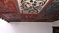
Painted coffered ceiling in the church

Pulpit in the church


Web links
Commons : Kémes - collection of images, videos and audio files
- Official website ( Hungarian )
- Kémes község címere (Hungarian)