Book forest
|
Buchforst district 902 of Cologne |
|
|---|---|
| Coordinates | 50 ° 57 '3 " N , 7 ° 0' 18" E |
| surface | 0.830.5 km² |
| Residents | 7544 (Dec. 31, 2017) |
| Population density | 9084 inhabitants / km² |
| Incorporation | Oct. 25, 1932 ( independent district ) |
| prefix | 0221 |
| Borough | Mulheim (9) |
| Transport links | |
| Federal road |
|
| Railway lines | S 6 S 11 |
| Light rail line | 3 |
| Bus routes | 159 171 |
| Source: 2017 residents . (PDF) Cologne district information | |
Buchforst is a district on the right bank of the Rhine in Cologne in the Mülheim district .
location
Buchforst borders the Buchheim district in the east, the Kalk district in the south and Mülheim in the west and north . The borderline of Buchforst is in the south the federal highway 55a, and in the other directions the railway lines of the DB.
history
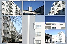
The eponymous former forest area was not significantly settled until the 20th century. After the non-profit public limited company for housing had acquired 18 hectares of land in the so-called Kalkerfeld in 1926 , it was developed as building land. The Blauer Hof estate was built north of Karlsruher Strasse from 1926 to 1927 and the White City to the south from 1929 to 1932 . The architects of the settlements, Wilhelm Riphahn and Caspar Maria Grod, also designed the Buchforster Catholic parish church of St. Petrus Canisius . It was not until 1932 that the entire settlement area was named Buchforst.
Blauer Hof and the White City were entered in the list of monuments in 1988 as group monuments.
Demographic statistics
Structure of the population of Cologne-Buchforst:
- Share of under 18s: 16.8% (2015)
- Proportion of over 64-year-olds: 17.0% (2015)
- Proportion of foreigners: 28.0% (2015)
- Unemployment rate: 16.0% (2014)
traffic
- In 1986, the construction of the Köln-Buchforst train station began, which opened in 1990; S-Bahn lines 6 and 11 now stop here.
- Buchforst is also served by tram line 3 and bus line 159.
- There is a feeder ( B55a ) to the Köln-Ost motorway junction .
Worth seeing
- Blue court
- White city
- Catholic parish church St. Petrus Canisius on the corner of Cusanusstrasse and Voltastrasse. The church was built in 1930/31 by the architects Wilhelm Riphahn and Carl Maria Grod as part of the White City . It is the only Bauhaus-style church in Cologne. The church was destroyed between 1942 and 1944. The reconstruction took place in 1948 by the architects Professor Dominikus Böhm and son Gottfried Böhm . The interior was designed by Maria Schwarz in the early 1990s .
- Evangelical Resurrection Church in Kopernikusstrasse. The church was built from 1965 to 1967 by Georg Rasch and Winfried Wolsky and on October 2, 1992, including two squares, the paving of which extends into the church building, was listed as a historical monument. The church is an internationally acclaimed and widely published example of church building in the 1960s. The church, which was abandoned in 2005, has been used as a meeting center since 2012.
- Weekly market on Waldecker Straße (every Wednesday and Saturday from 7:00 a.m. to 1:00 p.m.). The weekly market has been held since 1938.
- Monuments in Buchforst
- Kalkberg , a mountain with an impressive 360 degree panorama over all Cologne districts on the right bank of the Rhine
Web links
- Official website of the city of Cologne on the Buchforst district
- Working group beautiful book forest
- Development concept on the right bank of the Rhine sub-area north
- White City and Blauer Hof at baukunst-nrw
Individual evidence
- ↑ Inhabitants according to selected age groups - data source: City of Cologne - offenedaten-koeln.de
- ↑ Inhabitants according to selected age groups - data source: City of Cologne - offenedaten-koeln.de
- ↑ Inhabitants by type of migration background - data source: City of Cologne - offenedaten-koeln.de
- ↑ Employed and unemployed part of the city - data source: City of Cologne - offenedaten-koeln.de


