
Kahlenberg (Wutha-Farnroda)
|
Kahlenberg
Wutha-Farnroda municipality
Coordinates: 50 ° 57 ′ 6 ″ N , 10 ° 25 ′ 9 ″ E
|
|
|---|---|
| Height : | 259 (250-270) m |
| Area : | 5.14 km² |
| Residents : | 360 (June 1, 2009) |
| Population density : | 70 inhabitants / km² |
| Incorporation : | April 14, 1994 |
| Postal code : | 99848 |
| Area code : | 036921 |
 Location of Kahlenberg in Wutha-Farnroda
|
|
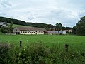
 The "Heuhotel" at the Gasthof Zapfengrund in the middle of the village
|
|
Kahlenberg is a district of the municipality of Wutha-Farnroda in West Thuringia.
location
The district with 360 inhabitants lies at an altitude of about 250 to 270 meters and extends as a forest hoof settlement on the right bank of the Hörsel over a length of about 2.7 kilometers.
history
Kahlenberg was first mentioned in 1133. As the fiefdom holders of the Fulda Monastery , the Lords of Wangenheim determined what was going on in the village for centuries.
Since the 13th century, the people of Wangenheim had spread from their ancestral home in the Nessetal to the areas of the Emsetal and central Hörsel valley bordering to the west and south . The Wangenheim property ( Wangenheim court ), which was combined to form the Wintersteiner administrative and judicial district, comprised six Waldhufendörfer, in addition to Kahlenberg: Castle and Village Winterstein , the villages Kälberfeld , Schönau , Deubach and Sondra . There were further rights and possessions in Fischbach , Sättelstädt , Wolfsbehringen and Oesterbehringen as well as the Heßwinkel and Hütscheroda farms . The Kahlenberg Castle, which they built during the Thuringian War of Succession , only lasted for a short time, its exact location has been forgotten. The topography of the terrain at the foot of the Hörselberge initially prevented the development of a town center; the settlement, which had barely more than 12 courtyards, was located on the high bank of the Hörsel , with the individual courtyards being isolated or in groups of 200 to 300 m apart. At the Seehof an old road crossed the Hörseltal with the Via Regia and offered a road connection over the Burbacher Pass into the Nessetal near Wenigenlupnitz or past Rehberg and Wittgenstein Castle into the Erbstromtal .
Family divisions, inheritances and pledges left a large number of documents that were the basis for an extensive family chronicle of the Wangenheimers in the 19th century.
Johann Georg August Galletti, a Gotha historiographer, describes the living conditions in the village of Kahlenberg around 1775 in his history and description of the Duchy of Gotha:
- The inhabitants live partly from agriculture, partly from day-labor. The community also has brewing rights, which the residents exercise in turn. The Pergschlag also belongs to them. There is very little water, because there are only a few wells, and the water has to be carried with great effort and inconvenience from the Hoersel to the mountain. The inhabitants turn the fruit that the trees in the meadows and in the field bear into the well-known essence, which, because of its goodness, is often sold for wine. But there are also some linen weavers, 1 bricklayer and a carpenter among them. The residents are parish off to Schoenau.
Due to inheritance divisions and sales, the original settlement stock had grown from 12 farmsteads in the middle of the 18th century to a total of 27 farms known by name (the "Schwarzengut" as well as Seehof, Eckhof, Waldhof, Rehhof, Backhaushof) and houses. The following development of the population results from statistical data series:
|
|
|
In the Thirty Years War Kahlenberg was attacked by Wallenstein's horsemen in 1625, followed by Swedish horsemen and in 1628 the Croats who burned almost half the village. A remote building known locally as “the black house” was used by the villagers as a place of convalescence or death from plague and other epidemics.
The first Hörsel bridge was built at Rehhof in 1856; previously, fords in the Hörsel were used, which was often problematic in winter. The "Pfarrsteg" was intended as a wooden footbridge only for pedestrians and also served as a safe river crossing for school children. The bridge at the Seehof to the Rehhof was renewed in 1955. The already 100-year-old bridge at the level crossing near Schönau was destroyed by floods in 1956, the successor building was also destroyed in 1961. The last bridge, inaugurated in 1962, had so far been able to cope with all natural disasters.
After the Second World War, 14 farmers in Kahlenberg owned an agricultural area of more than 10 hectares, the majority of the Kahlenbergers worked as part-time farmers. LPG Hörselberg was founded on September 14, 1958. A machine-tractor station should maintain the agricultural machines and guarantee that they can be used by the cooperative. On January 1, 1960, LPG Type III Edwin Hörnle was founded in Kahlenberg, and cattle stalls and a barn were built at the Seehof.
The most important farm in the village was the Waldhof , it was acquired in 1917 by the ancestor of the current owner, the domain leaseholder Berhard Schnorr . From 1960 onwards, up to 40 dairy cows were housed in the farm. Since 1990 the Waldhof has been an organic farm and with the adjacent Zapfengrund riding stables has become the center of the village.
Construction of the "Auf der Hutweide" housing estate began in August 1993. Around 160 people live in the residential complex, which is mainly made up of terraced houses - more than half of the Kahlenbergers are “new residents”.
In June 1998 the village became a living museum - for the 750th anniversary celebration, old handicraft customs and techniques were demonstrated, there were choir meetings and music events as well as demonstrations by the local associations of Wutha-Farnroda. The still agricultural location with many part-time farms, some listed half-timbered houses from the 18th and 19th centuries and the housing estate is generally considered a traffic-calmed zone without a multi-lane thoroughfare. The route of federal motorway 4 , which was dismantled in spring 2010 , will be renatured.
On the western outskirts of Kahlenberg is the headquarters of the cosmetics product manufacturer Herbacin and the extensive grounds of the former Elisabethenhöhe school home from the 1930s, where a modern care facility for disabled people was created under the sponsorship of the Diakonie-Verbund Eisenach. A local model workshop specializes in mold making.
The ceramist Barbara Grusser lives and works in the village. In the 1980s she made a name for herself with lovingly designed animal figures among collectors in the region and was given several opportunities to present her works in the Thuringian Museum .
Attractions
- The little Jesus fountain on the ascent to the Großer Hörselberg reminds of the time of the shepherds and shepherds who once wandered through the corridors of the community with their flocks.
- The place is of tourist importance as a starting point for hiking tours to the Hörselberge or into the Thuringian Forest. The organic farm of the same name with riding stables at the entrance to the Zapfengrund also has a hay hotel for overnight stays.
- Herbal Sunday (beginning of June) is a highlight of the year, at the so-called Apothekenwiese at the end of the Zapfengrund there is an annual church service. The gathering of medicinal herbs for medicinal purposes has a long tradition in the region.

The corner courtyard

Typical homestead
LPG now privatized farm in Kahlenberg

Excursion to the Zapfengrund on Herb Sunday


literature
- Lutz Baumbach, Birgit Eichler, Christina Reißig, etal: Commemorative publication for the local anniversary 750 years of Kahlenberg . Heimatverlag Hörselberg, Wutha-Farnroda 1998, p. 94 .
- Illustrated books Wutha-Farnroda Volumes I – IV . Geiger, Horb am Neckar 1991, 1992, 1997 and 2003, ISBN 3-89264-596-5 , ISBN 3-89264-706-2 , ISBN 3-89570-284-6 and ISBN 3-89570-859-3 .
Web links
Individual evidence
- ↑ Official topographic maps of Thuringia 1: 10,000. Wartburgkreis, district of Gotha, district-free city of Eisenach . In: Thuringian Land Survey Office (Hrsg.): CD-ROM series Top10 . CD 2. Erfurt 1999.
- ^ Friedrich Hermann Albert von Wangenheim, Regesta and documents on the history of the Wangenheim family , Vol. I Hanover 1857, Vol. II Göttingen 1872
- ^ Friedrich Hermann Albert von Wangenheim, Contributions to a family history of the Barons von Wangenheim (..) on the basis of the previous two document collections , Huth Göttingen 1874. Digitized edition of the University and State Library Düsseldorf
