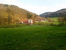
Kaltenbrunn (Walldürn)
|
Kaltenbrunn
City of Walldürn
|
|
|---|---|
| Coordinates: 49 ° 38 ′ 50 ″ N , 9 ° 21 ′ 30 ″ E | |
| Height : | 327 m |
| Area : | 2.34 km² |
| Residents : | 41 |
| Population density : | 18 inhabitants / km² |
| Incorporation : | 1st January 1975 |
| Postal code : | 74731 |
| Area code : | 06286 |
Kaltenbrunn is a district of Walldürn in the Neckar-Odenwald district in the north of Baden-Württemberg . The Spritzenmühle residential area also belongs to the place.
Geographical location
The hamlet-like village of Kaltenbrunn is the northernmost district of Walldürn, about 7.5 kilometers away from the city center on the border with Bavaria and the Miltenberg district . The syringe mill is located about one kilometer below the village at the confluence of the Eichelbach and Kaltenbach rivers . The Neckartal-Odenwald Nature Park includes parts of the district.
history
The high medieval clearing settlement was first mentioned in 1330 as Kaltenburn and was probably owned by the Amorbach monastery at the beginning . In the 15th century, the lords of Adelsheim owned half of the town and sold it to the Amorbach monastery in 1498. Kaltenbrunn belonged to Kurmainz until 1803 and came to the Principality of Leiningen as part of secularization and to the Grand Duchy of Baden in 1806 .
From 1935 to 1945 Kaltenbrunn belonged to the Glashofen community . On January 1, 1975, it was incorporated into Walldürn. Kaltenbrunn forms a common village with Reinhardsachsen .
Until 1908 the place belonged to the Catholic parish Walldürn, since then to Glashofen.
Former coat of arms
In 1909 Kaltenbrunn adopted the following coat of arms at the suggestion of the General State Archives: "A red-lined, gold- (yellow) -borded silver (white) miter and a golden (yellow) crook", diagonally crossed in blue. The coat of arms expired on January 1, 1975 when it was incorporated into Walldürn.
Cultural monuments
economy
Kaltenbrunn is an exclusively agricultural place.
Web links
- Kaltenbrunn on the Walldürn website
Individual evidence
- ↑ Kaltenbrunn at www.wallduern.de , accessed on March 9, 2015
- ↑ Ordinance of the Ministry of Food, Agriculture, Environment and Forests Baden-Württemberg on the "Neckartal-Odenwald" nature park of October 6, 1986 (Journal of Laws of December 23, 1986, p. 446). Section 2, Paragraph 2. LUBW State Institute for the Environment, Measurements and Nature Conservation Baden-Württemberg, accessed on March 13, 2015 .
- ↑ Kaltenbrunn. LEO-BW, discover regional studies online, accessed on March 9, 2015 .
- ^ Federal Statistical Office (ed.): Historical municipality directory for the Federal Republic of Germany. Name, border and key number changes in municipalities, counties and administrative districts from May 27, 1970 to December 31, 1982 . W. Kohlhammer, Stuttgart / Mainz 1983, ISBN 3-17-003263-1 , p. 485 .
- ↑ The coat of arms of Walldürn and its districts. Walldürn website, accessed on March 9, 2015 .

