Kalungwishi
| Kalungwishi | ||
|
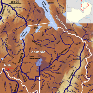
The river system of the Luvua with the Kalungwishi (middle) |
||
| Data | ||
| location |
|
|
| River system | Congo | |
| Drain over | Luvua → Lualaba → Congo → Atlantic | |
| source | Near Kapatu | |
| Source height | 1600 m | |
| muzzle |
Mwerusee coordinates: 9 ° 2 '4 " S , 28 ° 55' 57" E 9 ° 2 '4 " S , 28 ° 55' 57" E |
|
| Mouth height | 931 m | |
| Height difference | 669 m | |
| Bottom slope | 3 ‰ | |
| length | 220 km | |
| Catchment area | 45,000 km² | |
| Right tributaries | Luangwa | |
| Navigable | No | |
|
The Mweru Lake with the Kalungwishi flowing in from the right (NASA photo) |
||
The Kalungwishi is a river in Zambia .
course
It rises at an altitude of 1600 m near the town of Kapatu, 100 km northeast of Kasama in the northern highlands of Zambia in its northern province . The Kalungwishi first flows 150 km to the west, then 70 km to the northwest and flows into the Mweru Lake at Kafulwe Mission , a very densely populated area . Shortly before the estuary, it takes in the water from the Mweru-Wantipa lake from the north . The river drains an area of 45,000 km².
tourism
The Kalungwishi is a popular safari destination in the north. It offers a whole series of impressive waterfalls: the Lumangwe Falls , Chimpepe Falls , Kabweluma Falls , Kundabwiku Falls and Mumbuluma Falls .
Energy generation
The great gradients in the river have attracted the interest of electricity producers in Zambia. It would be an ideal source of energy to supply the north of the country.

