
Karlsruhe ridge
| Karlsruhe ridge | ||
|---|---|---|
 Climbing on the Karlsruhe ridge |
||
| height | 750 m above sea level NHN | |
| location |
Baden-Wuerttemberg , Germany |
|
| Mountains | Black Forest | |
| Coordinates | 48 ° 33 '48 " N , 8 ° 11' 24" E | |
|
||

The Karlsruher Grat is an approximately 400 meter long rock ridge near Ottenhöfen in the Black Forest , over which an alpine route with climbing section leads, which is also known as the only via ferrata in the northern Black Forest .
location
The Karlsruher Grat is located in the Gottschläge-Karlsruher Grat nature reserve , east of Ottenhöfen and south of the Hornisgrinde in the northern Black Forest . The nature reserve extends to the western slopes of the dairy and Vogelskopf from 400 meters in the west to 830 m above sea level. NHN in the east. There, the district road 5370, which leads from Oppenau via Allerheiligen Abbey to the Black Forest High Road , forms the border to the Black Forest National Park and the Schliffkopf nature reserve . The ridge runs at a height of around 750 meters above the Gottschläge valley.
Surname
The name Karlsruher Grat is not original. In the past, the entire edge of the ridge was called Eichhaldenfirst (because of its resemblance to a roof ridge ) . When the ridge became an attraction for climbers from the surrounding area due to the popularization of climbing, especially from the Karlsruhe area, and the first deaths had to be reported, the Ottenhöfen community renamed it in 1926 in honor of the people who had died in Karlsruhe.
geology
The rocks and the ridge, the ridge of which they form, consist of quartz porphyry , more precisely the Grünberg quartz porphyry of the Geisberg Formation , which was formed around 290 million years ago when the magma filling a four kilometer long and 750 meter wide rock crevice cooled down. In some places the traces of the flow can still be seen. Over the granite of the basement and the quartz porphyry, which was penetrated much later, massive deposits of river sediments , the layers of red sandstone , were deposited in the course of the earth's history . The harder and thus more resistant porphyry was formed as a ridge by erosion , while the other, softer rocks were removed.


Via ferrata
The so-called via ferrata , which is mostly used from Ottenhöfen , leads along the ridge from west to east over the rough and therefore very hard-wearing porphyry rocks. The alpine route, which is demanding in sections, is exposed in some places and dangerous to fall, but - in contrast to alpine via ferrata - not provided with wire ropes or step aids.
The Karlsruher Grat is accessible from the Schwarzwaldhochstraße, but it is mostly walked from the hiking car park at the Edelfrauengrabwasserfalls in Ottenhöfen. The path leads from the hiking car park after the gravel works into the Gottschlägbach gorge, past the Edelfrauengrab cave and numerous waterfalls, always uphill, always on the left side of the slope in the sense of the ascent, then branches further back in the valley from a wide logging path to the left at an acute angle and leads up to the ridge. At the top, follow the signs for climbing . From the Bosensteiner Eck, follow the blue diamond downhill to the west and after a few hundred meters you will come across the first porphyry rocks.
The route is not marked, which is why everyone can walk more or less close to the edge of the ridge, depending on their ability and ability. Surefootedness and a head for heights as well as good footwear are required in any case. You should also avoid the ridge after rain because of the risk of slipping. The climbing takes about half an hour to an hour, depending on your ability. For inexperienced users, there is a narrow forest path on the northern edge of the ridge to - complete or partial - bypass. Aside from the via ferrata, climbing in the nature reserve is only permitted at one point on the ridge, the Eichhaldenfirst.
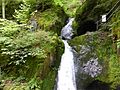
Noble grave waterfall
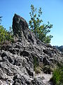
Porphyry column
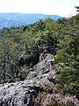
Looking west
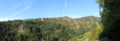
Panorama picture

Cross on the Karlsruhe ridge


Destinations in the area

Nearby - and connectable with the Karlsruhe ridge for a 10 to 15 kilometer hike - are located
- In the direction of Ottenhöfen: the granite rock pulpit of the Brennte Schrofen with a good view of Ottenhöfen and the surrounding area and the Gottschlägbach waterfalls with the Edelfrauengrab cave , in which, according to a legend, the wife of the lord of the castle of Bosenstein was walled up alive.
- and towards Oppenau : the ruins of the Allerheiligen monastery with its waterfalls .
literature
- Otto F. Geyer , Manfred Gwinner , Matthias Geyer, Edgar Nitsch and Theo Simon: Geology of Baden-Württemberg. 5th completely revised edition, 627 pages, Schweizerbart, Stuttgart 2011, ISBN 978-3-510-65267-9 .
Web links
- Nature reserve Gottschläge - Karlsruher Grat - information brochure of the District Office for Nature Conservation and Landscape Management (BNL) Freiburg (PDF; 3 MB)