Katagami (Akita)
| Katagami-shi 潟 上市 |
||
|---|---|---|
|
|
||
| Geographical location in Japan | ||
| Region : | Tōhoku | |
| Prefecture : | Akita | |
| Coordinates : | 39 ° 53 ' N , 139 ° 59' E | |
| Basic data | ||
| Surface: | 97.96 km² | |
| Residents : | 31,923 (October 1, 2019) |
|
| Population density : | 326 inhabitants per km² | |
| Community key : | 05211-6 | |
| Symbols | ||
| Flag / coat of arms: | ||
| town hall | ||
| Address : |
Katagami City Hall 47 - 100 , Aza Kamiegawa, Tennō Katagami -shi Akita 010-0201 |
|
| Website URL: | http://www.city.katagami.akita.jp | |
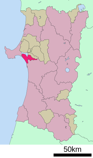
| Location Katagamis in Akita Prefecture | ||
Katagami ( Japanese 潟 上市 , -shi ) is a city in Akita Prefecture on Honshū , the main island of Japan .
geography
Katagami is north of Akita on the Sea of Japan .
history
The city of Kagagami was founded on March 22, 2005 from the amalgamation of the communities of Tennō ( 天王 町 , -machi ), Iitagawa ( 飯 田 川 町 , -machi ) and Shōwa ( 昭和 町 , -machi ) in the district of Minami-Akita .
traffic
- Train:
- Street:
- Akita Highway
- National road 7 : to Aomori and Niigata
- National road 101
- Rest areas:
- Showa; on Route 7 ("Akita Flower Fair")
- Tenno; on Route 101 ("Greenland")
sons and daughters of the town
Neighboring cities and communities
Web links
Commons : Katagami - collection of images, videos and audio files


