Yokote
| Yokote-shi 横 手 市 |
||
|---|---|---|
| Geographical location in Japan | ||
|
|
||
| Region : | Tōhoku | |
| Prefecture : | Akita | |
| Coordinates : | 39 ° 19 ′ N , 140 ° 33 ′ E | |
| Basic data | ||
| Surface: | 693.04 km² | |
| Residents : | 86,499 (October 1, 2019) |
|
| Population density : | 125 inhabitants per km² | |
| Community key : | 05203-5 | |
| Symbols | ||
| Flag / coat of arms: | ||
| town hall | ||
| Address : |
Yokote City Hall 269 Aza Shimo-Sanmaibashi, Mägo Yokote shi Akita 013-8601 |
|
| Website URL: | http://www.city.yokote.lg.jp/ | |
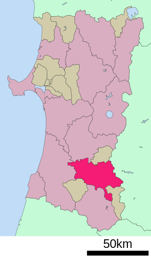
| Location Yokotes in Akita Prefecture | ||
Yokote ( Japanese 横 手 市 , -shi ) is a city in Akita Prefecture on Honshū , the main island of Japan .
geography
Yokote is southeast of Akita and north of Yamagata . The Ōu Mountains are east of the city. The Omono flows through the city.
history
On April 1, 1951 , Machi Yokote , which was founded in 1889, became Shi through the incorporation of surrounding villages , which has since grown further through further incorporations.
traffic
- Street:
- Akita Highway
- National Road 13 : to Fukushima and Akita
- National roads 107, 342, 397
- Train:
Local festivals
Yokote is known for its Kamakura Festival, a mid-winter festival where small mini igloos are built across the city. It is celebrated in the days after the Bonden Festival (mid-February).
Neighboring cities and communities
- Akita Prefecture
- Iwate Prefecture
Town twinning
sons and daughters of the town
- Ishikawa Tatsuzō (1905–1985), writer
- Mitsu Dan (* 1980), actress
- Sayuri Sugawara (* 1990), singer
Web links
Commons : Yokote - collection of pictures, videos and audio files


