Nikaho
| Nikaho-shi に か ほ 市 |
||
|---|---|---|
|
|
||
| Geographical location in Japan | ||
| Region : | Tōhoku | |
| Prefecture : | Akita | |
| Coordinates : | 39 ° 12 ' N , 139 ° 54' E | |
| Basic data | ||
| Surface: | 240.65 km² | |
| Residents : | 23,602 (October 1, 2019) |
|
| Population density : | 98 inhabitants per km² | |
| Community key : | 05214-1 | |
| Symbols | ||
| Flag / coat of arms: | ||
| town hall | ||
| Address : |
Nikaho City Hall 1 Aza Hamanota, Kisakata-machi Nikaho shi Akita 018-0113 |
|
| Website URL: | http://www.city.nikaho.akita.jp | |
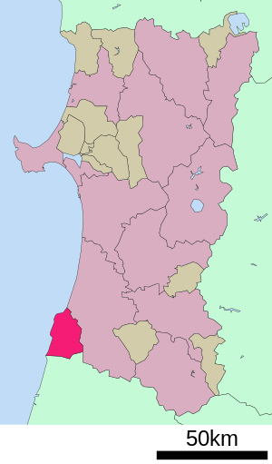
| Location Nikahos in Akita Prefecture | ||
Nikaho ( Japanese に か ほ 市 , -shi ) is a city in Akita Prefecture on Honshū , the main island of Japan .
geography
Nikaho is south of Akita and north of Sakata on the Sea of Japan .
history
The city of Nikaho was founded on October 1, 2005 from the merger of the communities of Kisakata ( 象 潟 町 , -machi ), Konoura ( 金 浦 町 , -machi ) and Nikaho ( 仁 賀 保 町 , -machi ) in Yuri County. The district was then dissolved.
Attractions
- Naso no Shirataki waterfall
traffic
- Street:
- National road 7 : to Aomori and Niigata
- Train:
- JR Uetsu Main Line : to Niigata and Akita
sons and daughters of the town
- Shirase Nobu (1861–1946), officer and polar explorer
Neighboring cities and communities
- Akita Prefecture
- Yamagata Prefecture
Web links
Commons : Nikaho - collection of images, videos and audio files


