Taggenbrunn cadastral community
| Taggenbrunn ( cadastral community ) | ||
|---|---|---|
|
|
||
| Basic data | ||
| Pole. District , state | Sankt Veit an der Glan (SV), Carinthia | |
| Judicial district | Sankt Veit an der Glan | |
| Pole. local community | St. Georgen am Längsee | |
| Coordinates | 46 ° 46 '14 " N , 14 ° 23' 17" E | |
| Area d. KG | 65.57 ha | |
| Statistical identification | ||
| Cadastral parish number | 74533 | |

|
||
| Source: STAT : index of places ; BEV : GEONAM ; KAGIS | ||
The cadastral municipality of Taggenbrunn is one of six cadastral municipalities in the municipality of Sankt Georgen am Längsee in the district of Sankt Veit an der Glan in Carinthia . It has an area of 65.57 hectares.
The cadastral community belongs to the district of the Klagenfurt land surveying office.
location
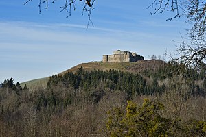
The cadastral municipality is located in the west of the municipality of Sankt Georgen im Längsee, in the south of the Sankt Veit an der Glan district, east of the district capital. The landscape is in the Sankt Veiter hill country . It only includes the hill in the area of a few hundred meters around Taggenbrunn Castle and a gravel road that extends from there over a kilometer to the northeast to the village of Dellach . The cadastral community extends over an altitude of 495 m above sea level. A. on the western edge of the cadastral community up to 645 m above sea level. A. in the area of the castle ruins.
Localities
In the area of the cadastral community of Taggenbrunn, part of the village of Taggenbrunn is located, as well as the outbuilding of a farm belonging to the village of Tschirnig on the southwestern edge of the cadastral community .
Surveying office district
The cadastral municipality has belonged to the district of the Klagenfurt land surveying office since January 1st, 1998. Before that, she was part of the district of the St. Veit an der Glan land surveying office.
history
At the end of the 18th century, the Carinthian tax communities (later: cadastral communities) were formed and assigned to tax districts. The Taggenbrunn tax community became part of the Osterwitz tax district .
In the course of the reforms after the revolution of 1848/49, the tax districts in Carinthia were dissolved and local communities were formed, each encompassing the area of one or more tax communities. The tax and cadastral municipality of Taggenbrunn became part of the municipality of Sankt Georgen . The size of the cadastral community was given in 1854 as 112 Austrian yokes and 1,123 fathoms (approx. 65 hectares, which corresponds to today's area); at that time 93 people lived in the area of the cadastral community.
The cadastral municipality of Taggenbrunn belonged from 1850 to the political district of Sankt Veit an der Glan and to the judicial district of Sankt Veit an der Glan . From 1854 to 1868 it belonged to the mixed district of Sankt Veit an der Glan . Since the reform in 1868, it has again been part of the political district of Sankt Veit an der Glan and the judicial district of Sankt Veit an der Glan.
Settlement development
At the turn of the year 1979/1980 there were a total of 10 building areas with 10,318 m² and 17 gardens on 43,077 m² in the cadastral municipality of Taggenbrunn , in 1989/1990 there were 9 building areas. In 1999/2000 the number of building areas had grown to 14 and in 2009/2010 there were 9 buildings on 14 building areas.
Land use
The cadastral community is characterized by agriculture. 33 hectares were used for agriculture at the turn of the year 1979/1980 and 24 hectares were forest areas. In 1999/2000 33 hectares of agriculture were carried out and 29 hectares were designated as areas used for forestry. At the end of 2018, 18 hectares were used as agricultural land and forestry was carried out on 20 hectares. The figures reflect that, in recent years, considerable parts of the forest around the castle have been cleared and replaced with vineyards. The average soil climate of Taggenbrunn is 39.2 (as of 2010).

