Kautzsch (Kreischa)
|
Kautzsch
community Kreischa
Coordinates: 50 ° 57 ′ 41 ″ N , 13 ° 46 ′ 2 ″ E
|
|
|---|---|
| Height : | 237 (200-240) m |
| Incorporation : | 1935 |
| Incorporated into: | Bärenklause-Kautzsch |
| Postal code : | 01731 |
| Area code : | 035206 |
|
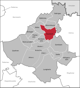
Location of Kautzsch in Kreischa
|
|
Kautzsch is a district of the Saxon community Kreischa in the district of Saxon Switzerland-Eastern Ore Mountains .
geography
Kautzsch is located south of the state capital Dresden and about three kilometers north of Kreischa. The settlement extends from a plateau down to the approximately 40-meter-low valley of Bärenklause , which reaches the Lockwitz near the Hummelmühle. This valley cut is called Respe or Rospe (mhd. Panicle = twig, bush). The local developments on the road to Brandmühle and the former school in Lockwitztal date from the 20th century.
Neighboring places
| Kleba | Bear Clause | Burgstädtel |
| Theisewitz |

|
|
| Zscheckwitz | Kreischa | Gombsen |
history
The first documented mention of the settlement from 1288 calls it Cudescowe (altsorb.), 1350 it is called Kushicz , then Kussewitz (1408) and in the 16th century it was separated into Großauczsch and Kleinkauczsch . The alley-like square village often changed hands over time, and at times even had two. In the 17th and 18th centuries, for example, the village belonged to the Zscheckwitz manor , the "tavern basically", the Kautzsch inn, the blacksmith's bar on the upper street and Kleinkautzsch belonged to the Borthen estate . Correspondingly, Kautzsch was also divided between the administrative offices of Dresden and Pirna , and it was always parish to Kreischa.
In 1839 Kautzsch became an independent municipality in the Dippoldiswalde district team . In 1935 it merged with Bärenklause to form an administrative unit Bärenklause-Kautzsch . The former farmer's settlement slowly transformed into a workers' housing estate with single-storey residential buildings.
In 1910 the community founded its own school system. The former schoolhouse at the end of the village in the direction of Hornschenke shaped the landscape due to its altitude until the striking tower with the school clock was removed during renovation.
The Brandmühle, which had two gears in 1721 , was in operation as a grinding mill until 1945. It can still be recognized from the wheel chamber in which the undershot water wheel ran. The keystone of the arched doorway indicates the year of construction 1803.
Web links
- Kautzsch in the Digital Historical Directory of Saxony
- Kautzsch on kreischa.de


