Gombsen
|
Gombsen
community Kreischa
Coordinates: 50 ° 57 ′ 7 ″ N , 13 ° 46 ′ 43 ″ E
|
|
|---|---|
| Height : | 200 (186-228) m |
| Residents : | 514 (2011) |
| Incorporation : | 7th October 1973 |
| Postal code : | 01731 |
| Area code : | 035206 |
|
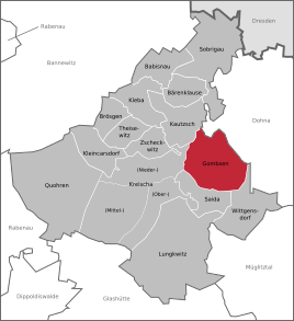
Location of Gombsen in Kreischa
|
|
Gombsen is a district of the Saxon community Kreischa in the district of Saxon Switzerland-Eastern Ore Mountains .
geography

The double-row village Gombsen is located south of the state capital Dresden and northeast of Kreischa.
Neighboring places
| Kautzsch | Sobrigau | Borthen |
| Theisewitz |

|
Neuborthen |
| Kreischa | Saida | Wittgensdorf |
history
The place name is derived from the Old Slavic term Komašin and means village of Komaš .
The first written mention of Gombsen comes from the year 1445. In 1445 the place belonged to the care Dohna , 1526 to the care Dresden. From 1843 Gombsen was part of the Pirna office . After that, the place belonged to the Dippoldiswalde court office from 1856 to 1875 , then to the office of the same name . In 1939, the neighboring town of Saida was incorporated, on July 1, 1950 Wittgensdorf. In 1952 Gombsen became part of the Freital district (later the district ). On January 1, 1974, it was incorporated into Kreischa. In the course of the district reform in Saxony in 1994 , Kreischa and its districts became part of the newly formed Weisseritz district from the districts of Freital and Dippoldiswalde . This was August 1, 2008 with the District Saxon Switzerland for District Saxon Switzerland-Osterzgebirge combined.
Development of the population
|
|
literature
- Gombsen, Gommsen, Gompsen . In: August Schumann : Complete State, Post and Newspaper Lexicon of Saxony. 3rd volume. Schumann, Zwickau 1816, p. 266.
Web links
- Gombsen in the Digital Historical Directory of Saxony
- Gombsen on kreischa.de
Individual evidence
- ↑ Small-scale municipality sheet: 2011 census. State Statistical Office of the Free State of Saxony, 2014, accessed on August 5, 2017 .
- ↑ a b Gombsen. In: kreischa.de. Retrieved July 26, 2014 .
- ^ Academy of Sciences of the GDR. Institute of Geography. Local research group (Ed.): Between Tharandter Wald, Freital and the Lockwitztal: Results of the local history inventory. (Values of our homeland) . tape 21 . Akademie-Verlag, Berlin 1973, ISBN 978-3-274-00758-6 , pp. 157 .
- ↑ a b Gombsen in the Digital Historical Directory of Saxony
- ↑ Small-scale municipality sheet: 2011 census. State Statistical Office of the Free State of Saxony, 2014, accessed on August 5, 2017 .


