Sobrigau
|
Sobrigau
community Kreischa
Coordinates: 50 ° 58 ′ 48 ″ N , 13 ° 46 ′ 59 ″ E
|
|
|---|---|
| Height : | 227 m |
| Residents : | 325 (2011) |
| Incorporation : | March 1, 1994 |
| Postal code : | 01731 |
| Area code : | 035206 |
|
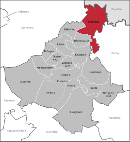
Location of Sobrigau in Kreischa
|
|
Sobrigau is a district of the Saxon community Kreischa in the district of Saxon Switzerland-Eastern Ore Mountains .
geography
Sobrigau is located south of the state capital Dresden and north of Kreischa. In the north the federal highway 17 passes. In the northwest is the Kauscha dam .
Neighboring places
| Goppeln | Kauscha , nod | Lockwitz |
| Gaustritz |

|
|
| Babisnau | Gombsen | Burgstädtel |
geology
The place is located on a steep slope of the Lockwitzbach far above the valley floor on a gently rising plateau of a Cretaceous sandstone slab. The loess clay cover of the sandstone offered good conditions for arable use of the plateaus.
Form of settlement and land form
The center of Sobrigau is a square called "Am Rundling ". The name refers to the original form of settlement of the village - a Slavic Rundling (Rundplatzdorf). The defining corridor shapes were block and strip corridor.
The names of the fields indicate the natural features of the historical landscape of Sobrigau. Names like Buschberg, Grundberg and Leiten can be found in the area of the slope edge of the Lockwitztal. Jackdaw or Duhle denote a depression on the way to Nickern and in three marl pits . The mining of marl was probably used for agricultural purposes. The calcareous clay was used as a fertilizer to increase soil fertility.
history
The place name is derived from the Old Slavic term Sobligor or the Old Sorbian word Sobě-lěgari and means people living on the side. The name indicates a Slavic settlement of the area.
The first written mention of Sobrigau comes from the year 1288. In 1442 the place belonged to the Dresden nursing home and in 1547 to the Dresden office . In 1843 Sobrigau was part of the Pirna office . After that, the place belonged to the Dresden court office from 1856 to 1875, then to the office of the same name . In 1952 the place became part of the Freital district (later the district ). On March 1, 1994, Sobrigau was incorporated into Kreischa. In the course of the district reform in Saxony in 1994 , Kreischa and its districts became part of the newly formed Weisseritz district from the districts of Freital and Dippoldiswalde . This was August 1, 2008 with the District Saxon Switzerland for District Saxon Switzerland-Osterzgebirge combined.
Dorfgasthof Sobrigau
The historic three-sided farm on the Rundling in Sobrigau is a listed building and was the old inn of the place. After the keystone above the entrance gate, the building was erected in 1728. Inscriptions on the courtyard wall (1606) indicate an older structure. The half-timbered upper floor stands on a massive sandstone base. An arched courtyard gate with a secondary gate serves as access to the courtyard. In 2010 the old village inn was refurbished in accordance with a listed building.
Chocolate factory
Konrad Otto Rüger's former chocolate factory is located in Lockwitzgrund near Sobrigau. In 1932 chocolate production was stopped due to competition and falling sales. Individual buildings were converted into residential buildings in the following years and 41 families moved into the former chocolate factory. In 1995 the Rügerschen heirs sold the property to EURAG Bauträger AG , which developed the building complex into the Lockwitztalaue residential park .
Bumblebee mill
The Hummelmühle is located in the Lockwitztal between Kreischa and Lockwitz. The name is derived from the field name homel , which stands for hill.
It was first mentioned in 1571 as a mill under Burgstadde l. Antinapoleonic troops badly damaged the Hummelmühle in 1813. Julius Hermann Opitz bought the mill at Lockwitzbach in 1858 and renewed it between 1869 and 1874. In order to increase the profitability of the company, he installed a steam engine. Until 1989, the mill functioned as a compound feed plant for the Borthen Agricultural Production Cooperative (LPG).
The long, steep slope behind the Hummelmühle in the direction of Burgstädtel has a large difference in altitude and is used as a toboggan hill for day-trippers from Dresden due to its topographical suitability and scenic location in the Lockwitztal. The length of the toboggan run is around 200 meters.
Orchard meadow
The Cistercian Altzelle monastery had owned a vineyard slope in Sobrigau since 1309. The approximately 4-hectare, steeply sloping and south-facing slope above the Lockwitztalgrund was particularly suitable for viticulture due to its favorable climate. A monastic farm in Dresden- Leubnitz obtained the harvest. In the second half of the 19th century, the abandoned vineyard slope was planted with fruit trees. The orchard meadow, covered with apple trees and characterizing the landscape, was gradually spent in the 21st century. Bushes consisting of blackberry, sloe and dog rose communities established themselves on the 40 percent steep slope. The nature conservation association Green League Dresden (Upper Elbe Valley) developed a de-bushing and maintenance concept in 2011. After the spring of 2012 the wood structures were roughly removed by motor-manual methods, the maintenance work began Graugehörnten Heidschnucke , which is a kind of Nordic short-tailed sheep is. Due to the low demands on keeping and the frugal diet, the Heidschnucke is particularly suitable for demanding landscape maintenance . The herd of this endangered livestock breed currently comprises 40 animals. The apple slope represents a historical cultural landscape element of the Lockwitztal. In spring, during the apple blossom, the white splendor of the numerous fruit trees is impressive. The cave-rich old wood trees of this orchard meadow offer the highly endangered Russian beetle (Osmoderma eremita) suitable habitat conditions.
Development of the population
|
|
Place name forms
In the course of history, the name of the place Sobrigau has changed many times.
- 1288: Szobelgor
- 1307: Zobelgor
- 1405: Czobelgar
- 1442: Subligor
- 1445/47: Sobligor
- 1465: Czarbigo
- 1476: Zcobligar
- 1479: Zcobergaw
- 1529: Subligar
- 1539: Sobliar
- 1545: Sobriga
- 1551: Sobigen
- 1568: Sobrie
- 1586: Sobrigaw
- 1718: Sobrigau
literature
- Cornelius Gurlitt : Sobrigau. In: Descriptive representation of the older architectural and art monuments of the Kingdom of Saxony. 24. Issue: Amtshauptmannschaft Dresden-Altstadt (Land) . CC Meinhold, Dresden 1904, p. 115.
Web links
- Sobrigau in the Digital Historical Directory of Saxony
- Sobrigau on kreischa.de
Individual evidence
- ↑ Small-scale municipality sheet: Census 2011. Kreischa. State Statistical Office of the Free State of Saxony, September 2014, accessed on November 1, 2017 .
- ↑ a b c d e f Academy of Sciences: Values of our homeland. Between Tharandt Forest and the Lockwitztal, Volume 21, Berlin: 1973
- ↑ a b c Digital historical directory of Saxony: Sobrigau. Institute for Saxon History and Folklore (ISGV), accessed on December 8, 2017 .
- ↑ a b c d e Sobrigau. In: kreischa.de. Retrieved July 27, 2014 .
- ^ Sobrigau in the Digital Historical Directory of Saxony
- ↑ Kreischaer messenger. http://www.kreischa.de/inhalte/kreischa/_inhalt/information_service/kreischaer_bote/bote_2011/bote_juli.pdf , July 5, 2011, accessed on December 9, 2017 .
- ↑ Monika Wessel: The Landhaus Sobrigau - A five-star holiday home. Retrieved December 9, 2017 .
- ^ Frank Melzer: Otto Rüger, Schokoladenfabrik im Lockwitzgrund 1860 to 1932. Accessed December 8, 2017 .
- ^ Frank Melzer: Hummelmühle bei Kreischa, since 1571. Retrieved on December 9, 2017 .
- ↑ Daniel Böcherer: At the Hummelmühle. Retrieved December 9, 2017 .
- ↑ Fruit and meadow treasures. Landschaftspflegeverband Sächsische Schweiz-Osterzgebirge eV, April 2015, accessed on December 9, 2017 .
- ↑ Small-scale municipality sheet: Census 2011. Kreischa. State Statistical Office of the Free State of Saxony, September 2014, accessed on November 1, 2017 .


