
Kibo (mountain)
| Kibo | ||
|---|---|---|
 The Kibo in the Kilimanjaro massif |
||
| height | 5895 m | |
| location | Tanzania , East Africa | |
| Mountains | Kilimanjaro massif | |
| Dominance | 5,509.7 km → Kuh-e Shashgal | |
| Notch height | 5885 m ↓ Suez Canal | |
| Coordinates | 3 ° 3 '54 " S , 37 ° 21' 33" E | |
|
||
| Type | Stratovolcano | |
| First ascent | October 6, 1889 by Hans Meyer , Ludwig Purtscheller , Yohani Kinyala Lauwo | |
| particularities | Highest mountain in Africa, UNESCO World Heritage ( UNESCO - 1987 ) |
|

The Kibo ( Swahili , German: “The Helle”) is at 5895 m the highest mountain in Africa and is therefore one of the Seven Summits . It is located in the Kilimanjaro massif , the highest mountain massif on the continent . Often the name Kilimanjaro is used to denote the highest mountain in Africa, but this is topographically incorrect, as this is the name of the entire high mountain range.
The Kibo is a part of the world natural heritage to which the Kilimanjaro massif was declared by UNESCO in 1987 .
geography
The Kibo is located about 340 kilometers south of the equator in northeastern Tanzania . It is the highest of the three dormant volcanoes (only with fumarolic activity) of the Kilimanjaro massif , which is located on the edge of the eastern branch ( Eastern Rift ) of the East African Rift in Kilimanjaro National Park . Its highest peak is called Uhuru Peak ( Uhuru (Swahili), German: "Freedom").
The Kibo is located around 10 km west of the Mawenzi ( 5148 m ), to which it is connected by an average of around 4300 m high saddle . Its summit rises 1598 m above this vast saddle, on which a barren cold desert predominates. To the west the terrain drops to the plateau-like Shira ( 3962 m ), which is about 15 km away from the Kibo.
Landscape image


The summit regions on the Kibo are still partly glaciated , whereby the remains of the ice cap are getting smaller and smaller (see also the landscape on Kilimanjaro ). It has been predicted that the ice on Kilimanjaro will melt in the coming decades.
On the expansive summit, in the frost rubble desert, is the 1.9 by 2.4 kilometer Kibo crater with ice and firn areas . Inside this crater lies the Inner Cone , the 5835 m high crater rim of the Reusch crater , which is around 800 m in diameter and around 200 m deep.
Rockclimbing
Climbing Kibo or Uhuru Peak offers mountaineers little technical difficulty. Usually five days are counted for ascent and descent. It is advisable to plan an additional day or two in order to achieve a minimal altitude adjustment. The ascent is chargeable; Moreover, the appointment of a is Dschagga -Führers and employment of local carrier prescribed. The way to the summit usually leads via the Marangu route (see also mountaineering on Kilimanjaro ).
summit
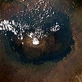
Satellite image of the Kilimanjaro massif with the white patch of ice and snow of the Kibo in the center

Sign combination 1 at Uhuru Peak

Stella Point from 2011


The highest point on the Kibo is Uhuru Peak, located on the southwestern rim of the crater, which was called Kaiser-Wilhelm-Spitze at the time of German colonial rule and was considered the highest mountain in the German Empire .
Individual evidence
- ↑ a b Kibo on Peakbagger.com (English).
- ↑ Monograph : Kilimanjaro, Tanzania .
- ^ Brian Vastag: The melting snows of Kilimanjaro . In: Nature . November 2, 2009, doi : 10.1038 / news.2009.1055 .
Africa: Kibo | Antarctica: Mount Vinson | Asia: Mount Everest | Australia / Oceania: Mount Kosciuszko • Puncak Jaya | Europe: Mont Blanc • Elbrus | North America: Denali | South America: Aconcagua