
Kienbach (Amper)
| Kienbach | ||
 Kienbach in Herrsching |
||
| Data | ||
| Water code | DE : 1643176 | |
| location | Bavaria | |
| River system | Danube | |
| Drain over | Ammersee → Amper → Isar → Danube → Black Sea | |
| origin | at Machtlfing 47 ° 56 ′ 3 ″ N , 11 ° 12 ′ 36 ″ E |
|
| Source height | 713 m above sea level NHN | |
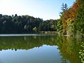
| muzzle | in the Ammersee near Herrsching Coordinates: 47 ° 59 '49 " N , 11 ° 9' 58" E 47 ° 59 '49 " N , 11 ° 9' 58" E |
|
| Mouth height | 533 m above sea level NHN | |
| Height difference | 180 m | |
| Bottom slope | 16 ‰ | |
| length | 11 km | |
| Outflow at the Herrsching gauge |
NNQ MNQ MQ MHQ HHQ |
1 l / s 19 l / s 128 l / s 2.61 m³ / s 8.2 m³ / s |
| Communities | Andechs , Herrsching am Ammersee | |
The Kienbach is an approximately 11 km long tributary of the Ammersee in Upper Bavaria .
course
The Kienbach arises in the south of the Andechs community, west of the Machtlfing district and north of the Kerschlacher forest. It flows in a north-westerly direction and crosses the Andechs district of Erling . From here it flows further north through the partly gorge-like Kiental and reaches Herrsching am Ammersee . There it turns to the west and flows into the Herrschinger Bucht of the Ammersee.
Character and environment
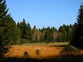
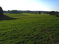
The Kienbach drains an area in the south of the municipality of Andechs, which lies between the Worm Ice Age moraines of two retreat stages of the Isar-Loisach Glacier , north of the 760 m high Berndorfer Buchet . This area is characterized by a large number of drumlins , between which there are wide meadows and smaller, partly wooded wetlands, including the Mesnerbichl nature reserve . The upper reaches of the Kienbach and its tributaries are mostly straightened meadow and moss ditches.
A distinctive section of the Kienbach north of Erling is the Kiental, which is up to 70 m deep and about 3.5 km long. Here, the Nagelfluhfelsen from the Minde Ice Age and, in the lower area, also pre- Ice Age marl are exposed . The Kiental is a popular hiking route. In particular, one can get through the Kiental from the Herrsching S-Bahn station to the nearby Andechs Monastery , a well-known excursion destination in the southwest of Munich .
Within Herrsching, which lies largely on an alluvial cone of the Kienbach, the Kienbach flows in a walled channel to the west until it reaches the spa gardens and flows into the Ammersee.

Geotope
The Kiental has been designated as a valuable geotope by the Bavarian State Office for the Environment (geotope number: 188R013).

Headwaters of the Kienbach east of Machtlfing
Maimoos on the upper reaches of the Kienbach south of Erling
Lüß on the upper reaches of the Kienbach, west of Machtlfing

Kienbach south of Erling
Upper pond south of Erling

Drumlins near Andechs (on the left the Andechs Monastery)

Kienbach in Erling
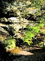
Nagelfluhfelsen in the Kiental
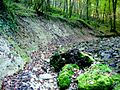
Impact slope made of flax marl in the Kiental
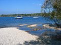
The mouth of the Kienbach in the Herrschinger Bay of the Ammersee


literature
- RKF Meyer, H. Schmidt-Kaler: Wanderings in the history of the earth. Volume 9. On the trail of the Ice Age south of Munich - western part. Publishing house Dr. Friedrich Pfeil, Munich 1997, ISBN 3-931516-10-5 .
Individual evidence
- ^ Flood news service Bavarian State Office for the Environment
- ↑ Bavarian State Office for the Environment, Geotop Kiental near Andechs (accessed on October 21, 2017).
Web links
- Map of the course and catchment area of the Kienbach on: BayernAtlas of the Bavarian State Government ( information )
- Water Management Office Weilheim
- Profile IS244 (tributaries of the Ammersee) of the Bavarian State Office for the Environment (PDF; 720 kB)
- Geotope information on the Kiental of the Bavarian State Office for the Environment (PDF; 194 kB)
- Kienbach in the Bavaria Atlas