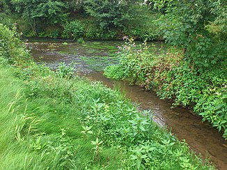
Kinzig (Mümling)
| Tiny | ||
|
The Kinzig in Etzen's buttocks |
||
| Data | ||
| Water code | DE : 24746 | |
| location |
Hessian-Franconian mountainous region
|
|
| River system | Rhine | |
| Drain over | Mümling → Main → Rhine → North Sea | |
| source | in Bad König - Gumpersberg 49 ° 46 ′ 21 ″ N , 8 ° 56 ′ 12 ″ E |
|
| Source height | 317 m above sea level NHN | |
| muzzle | at Bad König- Etzen-Gesäß in the Mümling coordinates: 49 ° 45 ′ 35 " N , 8 ° 59 ′ 45" E 49 ° 45 ′ 35 " N , 8 ° 59 ′ 45" E |
|
| Mouth height | 169 m above sea level NHN | |
| Height difference | 148 m | |
| Bottom slope | approx. 25 ‰ | |
| length | approx. 6 km | |
| Catchment area | 15.32 km² | |
| Drain |
MNQ MQ |
56 l / s 155 l / s |
|
The Kinzig (front right) flows into the Mümling |
||
The Kinzig is a 6 km long, left and western tributary of the Mümling in the Odenwaldkreis in Hesse .
geography
course
The Kinzig rises at an altitude of 317 m above sea level. NHN in a field southwest of a group of buildings northeast of the hamlet of Gumpersberg and north-northwest of the village of Ober-Kinzig . Both localities together with Mittel-Kinzig form the Ober-Kinzig district of the city of Bad König .
It flows first in a south-southeast, then in a southerly direction through grassland along the eastern edge of Ober-Kinzig. In the middle of the village, it is reinforced on the right by the Gumpersbergerbach coming from the village of the same name . From there it is sometimes called Gumpersbergerbach itself. At Mittel-Kinzig the Tiefenwiesengraben flows into it, which some also call Gumpersbergerbach to increase confusion.
It then changes more and more to the east and runs through meadows and fields, which are bordered on the right and left by forest. Shortly before it reaches the Nieder-Kinzig district of Bad Koenig , it is fed south of the Geisberg from the right by the Balsbach . From there she is only called Kinzig again.
It now passes the village in an easterly direction, then moves between the Sommerberg in the north and the Kinzinger Berg in the south through grassland and then reaches the western edge of the Bad Koenig district of Etzen-Gesäß .
It flows through the village, crosses under the tracks of the Odenwaldbahn and finally flows out at an altitude of 169 m above sea level. NHN directly north of Brombachtaler Straße from the left and west into Mümling, which is approaching from the south .
Its run, 6.0 km long, ends about 148 meters below its source, so it has a mean bed gradient of 25 ‰.
Catchment area
The 15.32 km² catchment area of the Kinzig is located in the Odenwald and is drained to the North Sea via the Mümling, the Main and the Rhine .
It borders
- in the south to that of the Brombach , which flows into the Mümling
- in the west to that of the Gersprenz tributary
- and in the north to that of the Oberhöchster Bach and that of the Forsteler Bach , both tributaries of the Mümling.
Tributaries
- Gumpersbergerbach ( GKZ 2474612 ) ( right ), 1.5 km
- Tiefenwiesengraben ( Gumpersbergerbach ) ( GKZ 2474614 ) ( right ), 1.3 km
- Balsbach ( right ), 4.2 km, 6.69 km²
places
The Kinzig flows through the following villages:
All of them belong to the city of Bad König
Mümling river system
Individual evidence
- ↑ Water map service of the Hessian Ministry for the Environment, Climate Protection, Agriculture and Consumer Protection ( information )
- ↑ a b see water profile and program of measures 24746.1
- ↑ Designation according to the property map
- ↑ Designation at WFD Hessen
Web links
- Water profile and program of measures 24746.1 ( Memento from January 1, 2013 in the web archive archive.today ) ( Notes ) → Overview of all Hessian river systems (PDF, 1.7 MB) Kinzig

