
Klimkovice
| Klimkovice | |||||
|---|---|---|---|---|---|
|
|||||
| Basic data | |||||
| State : |
|
||||
| Region : | Moravskoslezský kraj | ||||
| District : | Ostrava-město | ||||
| Area : | 1464 ha | ||||
| Geographic location : | 49 ° 47 ' N , 18 ° 8' E | ||||
| Height: | 382 m nm | ||||
| Residents : | 4,468 (Jan 1, 2019) | ||||
| Postal code : | 742 83 | ||||
| structure | |||||
| Status: | city | ||||
| Districts: | 4th | ||||
| administration | |||||
| Mayor : | Zdeněk Husťák (as of 2011) | ||||
| Address: | Lidická 1 742 83 Klimkovice |
||||
| Municipality number: | 599549 | ||||
| Website : | www.mesto-klimkovice.cz | ||||


Klimkovice ( German Königsberg in Schlesien ) is a town in Moravskoslezský kraj (Moravian-Silesian Region) in the Czech Republic .
Geographical location
The city is located in Moravia southwest of the city of Ostrava ( Ostrava ) near the historic border with Silesia .
history

The town was probably founded in the 2nd half of the 13th century by Ottokar II Přemysl . Koenigsberg, first documented in 1416, was a royal city in the territory of the Duchy of Opava .
In 1578 the governor Andreas Bzenec von Markwartowitz had the old fortress converted into a renaissance castle. In 1650 the Counts Wilczek became owners of the estate. Until 1918 the place belonged to Austrian Silesia . Königsberg was a small craft town in which the shoemaking and weaving industry dominated. The city belonging to the political district Wagstadt was the seat of a district court.
On December 1, 1930, the city of Königsberg had 3,240 inhabitants, of whom 229 were German. Before 1945 it was the only town in Opava Silesia with predominantly Czech populations. The Slavic-born inhabitants of the area speak Lechisch .
After the Munich Agreement in 1938 Konigsberg was of as part of the district Wagstadt , Region of Opava , in the Reich District of Sudetenland annexed to the German Reich. On May 17, 1939, the city had 2,918 residents. At the end of the Second World War, parts of the city were destroyed in fighting.
After the end of the war, Count Wilczek were expropriated and the German-speaking population group was expelled in 1946 . On May 22, 1947, the city had 2,710 residents again. In 2003, Klimkovice had 3779 inhabitants. On January 1, 2007, the reclassification from Okres Nový Jičín took place in the Okres Ostrava-město .
Demographics
| year | Residents | Remarks |
|---|---|---|
| 1900 | 2,381 | mostly Czech residents |
| 1910 | 2,696 | 2,667 permanent residents, mostly Catholics, 2,442 Czechs and 227 Germans |
| 1930 | 3,240 | |
| 1939 | 2,913 |
Local division
The city of Klimkovice consists of the districts Hýlov ( Hillau ), Josefovice ( Josefsdorf ), Klimkovice ( Königsberg ) and Václavovice ( Wenceslas village) and the localities of Fonovice ( Vonsdorf ) and Mexico ( Mexico II ).
- Location views

City Palace
chapel

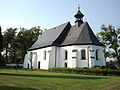
Katherinenkirche

Sebastian column

monument


Attractions
- Klimkovice Castle, built in 1578 as a Renaissance building in place of the old fortress and damaged by fire in 1854. Today it serves as the city administration
- Parish Church of St. Catherine, built at the beginning of the 17th century
Web links
Individual evidence
- ↑ Český statistický úřad - The population of the Czech municipalities as of January 1, 2019 (PDF; 7.4 MiB)
- ^ Meyer's Large Conversational Lexicon . 6th edition, Volume 11, Leipzig and Vienna 1907, pp. 385-389, Königsberg 5).
- ^ A b Michael Rademacher: German administrative history from the unification of the empire in 1871 to the reunification in 1990. Wagstadt district (Czech. Bílovec). (Online material for the dissertation, Osnabrück 2006).