
Kohlberg (Neuenrade)
| Kohlberg | ||
|---|---|---|
 The Kohlberg from the southeast. In the foreground the center of Neuenrades |
||
| height | 514 m above sea level NN | |
| location | Sauerland , Märkischer Kreis , North Rhine-Westphalia , Germany | |
| Mountains | Iserlohner Höhe , Märkisches Oberland , Süderbergland | |
| Coordinates | 51 ° 17 ′ 36 " N , 7 ° 46 ′ 0" E | |
|
||
| particularities | Quitmannsturm ( AT ) | |

The Kohlberg is a mountain in the Iserlohner Höhe in the Sauerland region of Brandenburg and, at 514 m, is the highest point in the town of Neuenrade . It forms the natural border between Neuenrade and the town of Altena and the district of Dahle .
The Hönne rises about one kilometer southwest of the summit .
On the Kohlberg, a ski lift , hanging lengths of up to 400 m and various cross-country trails offer winter sports, especially for beginners. In summer, it offers very good hiking opportunities with designated routes of the Sauerland Mountain Association and is one of the waypoints on the Sauerland-Höhenflug long-distance hiking trail leading from Altena to Korbach .
The 14 m high Quitmannsturm was built on the Kohlberg in 1893 as a lookout tower and was last renovated in 1986 by the city of Neuenrade.
Two architectural monuments of the city of Altena are also located on the Kohlberg: On the one hand, the memorial of the Sauerland Mountain Association built in 1938 in the immediate summit area and, on the other hand, the Kohlberghaus , which was inaugurated in 1926 as a meeting place for the Sauerland Mountain Association , which today serves as a care facility for people with mental and intellectual disabilities and located 300 m northwest of the highest point.

Aerial view of the Kohlberghaus
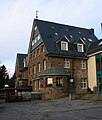
The Kohlberghaus
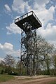
The Quitmannsturm

The Hönne spring


