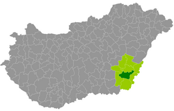
Békéscsaba district
| circle Békéscsabai járás
Békéscsaba |
|
|---|---|
 Location of the district in Hungary |
|
| Basic data | |
| Country | Hungary |
| County | Békés |
| Seat | Békéscsaba |
| surface | 636.2 km² |
| Residents | 80,613 (January 1, 2016) |
| density | 127 inhabitants per km² |
Békéscsaba (Hungarian Békéscsabai járás ) is an inland district in the southeastern Hungarian Békés County .
history
The district of Békéscsaba was created in the course of the Hungarian administrative reform in early 2013 as the successor to the small area of the same name (Hungarian: Békéscsabai kistérség ). The 6 communities were strengthened by three communities from neighboring small areas ( Békés and Orosháza ). Thus the area experienced an increase of 10,521 inhabitants (14.6%) or 185.43 square kilometers (41%).
The district has an average community size of 8,957 inhabitants on an area of 70.68 square kilometers. The population density of the most populous district is roughly twice the average of the district. Capital of the county and the district is Békéscsaba in the northeast of the district. The city has county rights (Hungarian Megyei jogú város ).
Community overview
| local community | status | Origin small area |
population | surface | Population density (inh / km²) |
||
|---|---|---|---|---|---|---|---|
| October 01, 2011 | 01/01/2013 | 01/01/2016 | |||||
| Békéscsaba | city | Békéscsaba | 62,050 | 61,046 | 60.126 | 193.93 | 310.0 |
| Csabaszabadi | local community | Békéscsaba | 331 | 314 | 274 | 32.71 | 8.4 |
| Csorvás | city | Orosháza | 5,060 | 4,962 | 4,789 | 90.18 | 53.1 |
| Doboz | Large community | Békés | 4,217 | 4,207 | 4.026 | 54.47 | 73.9 |
| Gerendás | local community | Orosháza | 1.314 | 1,352 | 1,272 | 40.78 | 31.2 |
| Ketsoprony | local community | Békéscsaba | 1,359 | 1,348 | 1,321 | 51.24 | 25.8 |
| Szabadkígyós | local community | Békéscsaba | 2,553 | 2,519 | 2,410 | 45.56 | 52.9 |
| Telekgerendás | local community | Békéscsaba | 1,461 | 1,450 | 1,386 | 72.37 | 19.2 |
| Újkígyós | city | Békéscsaba | 5,196 | 5,226 | 5,009 | 54.92 | 91.2 |
| Békéscsaba district | 83,541 | 82,424 | 80,613 | 636.16 | 126.7 | ||
swell
PDF and XLS files: 2011
Census :
2013:; 2016:
Individual evidence
- ↑ KSH: 2011. Évi Népszámlálás. In: 3. Területi adatok. KSH, accessed on December 24, 2016 (Hungarian, also via: http://www.terezvaros.hu/testuleti/nepsz2011-3/pdf/nepsz2011_03_04.pdf ).
- ↑ KSH: Regional data - Békés county. KSH, accessed on December 24, 2016 (English, 4th Data on Localities).
- ↑ KSH: Gazetteer of Hungary, 1st January, 2013. KSH, accessed on March 19, 2017 (Hungarian / English).
- ↑ KSH: Gazetteer of Hungary, 1st January, 2016. KSH, accessed on March 19, 2017 (Hungarian / English).