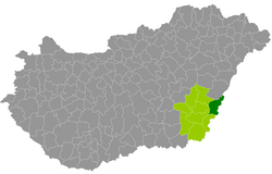
Sarkad County
| circle Sarkadi járás
Sarkad |
|
|---|---|
 Location of the district in Hungary |
|
| Basic data | |
| Country | Hungary |
| County | Békés |
| Seat | Sarkad |
| surface | 571 km² |
| Residents | 22,449 (January 1, 2016) |
| density | 39 inhabitants per km² |
The Sarkad District (Hungarian Sakardi járás ) is a district in the northwest of the southeast Hungarian Békés County . It borders Hajdú-Bihar County to the north and Romania (7 border municipalities) to the east . During the Hungarian administrative reform in early 2013, the district emerged unchanged from the small area of the same name ( Sarkadi kistérség ) (11 municipalities).
The Sarkad County has an average community size of 2,041 inhabitants in an area of 51.91 square kilometers. The population density of the poorest district is below that of the county. The administrative seat is the city of Sarkad in the south of the district.
Community overview
| local community | status | Origin small area |
population | surface | Population density (inh / km²) |
||
|---|---|---|---|---|---|---|---|
| October 01, 2011 | 01/01/2013 | 01/01/2016 | |||||
| Biharugra * | local community | Sarkad | 924 | 963 | 936 | 52.84 | 17.7 |
| Set * | local community | Sarkad | 790 | 830 | 786 | 51.39 | 15.3 |
| Körösnagyharsány * | local community | Sarkad | 564 | 568 | 513 | 19.91 | 25.8 |
| Kötegyán * | local community | Sarkad | 1,451 | 1,506 | 1,443 | 42.95 | 33.6 |
| Méhkerék * | local community | Sarkad | 2,093 | 2,090 | 2,061 | 25.85 | 79.7 |
| Mezőgyán * | local community | Sarkad | 1.104 | 1,117 | 1,052 | 60 | 17.6 |
| Okany | local community | Sarkad | 2,590 | 2,607 | 2,521 | 70.62 | 35.7 |
| Sarkad | city | Sarkad | 10,020 | 10,108 | 9,808 | 125.57 | 78.1 |
| Sarkadkeresztúr | local community | Sarkad | 1,563 | 1,587 | 1,487 | 35.30 | 42.1 |
| Újszalonta * | local community | Sarkad | 101 | 107 | 122 | 20.83 | 5.9 |
| Zsadany | local community | Sarkad | 1,708 | 1,745 | 1,720 | 65.84 | 26.1 |
| Sarkad County | 22,908 | 23,228 | 22,449 | 570.97 | 39.3 | ||
* Border municipality to Romania
swell
PDF and XLS files: 2011
Census :
2013:; 2016:
Individual evidence
- ↑ KSH: 2011. Évi Népszámlálás. In: 3. Területi adatok. KSH, accessed on December 24, 2016 (Hungarian, also via: http://www.terezvaros.hu/testuleti/nepsz2011-3/pdf/nepsz2011_03_04.pdf ).
- ↑ KSH: Regional data - Békés county. KSH, accessed on December 24, 2016 (English, 4th Data on Localities).
- ↑ KSH: Gazetteer of Hungary, 1st January, 2013. KSH, accessed on March 19, 2017 (Hungarian / English).
- ↑ KSH: Gazetteer of Hungary, 1st January, 2016. KSH, accessed on March 19, 2017 (Hungarian / English).