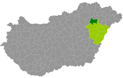
Hajdúnánás County
| circle Hajdúnánási járás
Hajdúnánás |
|
|---|---|
 Location of the district in Hungary |
|
| Basic data | |
| Country | Hungary |
| County | Hajdú-Bihar |
| Seat | Hajdúnánás |
| surface | 547.3 km² |
| Residents | 29,115 (January 1, 2016) |
| density | 53 inhabitants per km² |
Hajdúnánás (Hungarian Hajdúnánási járás ) is a district in the north of the eastern Hungarian county Hajdú-Bihar . It borders on the Balmazújváros County in the southwest and Hajdúböszörmény County in the east . In the West, forming Borsod-Abaúj-Zemplén ( circles Mezőcsát and Tiszaújváros ) the border in the north, the Szabolcs-Szatmár-Bereg ( county tiszavasvári ).
history
The new district created for the administrative reform in Hungary at the beginning of 2013 largely emerged from the Polgár (Hungarian: Polgári kistérség ) small area that was dissolved at the end of 2012 . The new district was also enlarged by the seat of the district from the small area Hajdúböszörmény (Hungarian Hajdúböszörményi kistérség ) to the east .
Community overview
Hajdúnánás County has an average parish size of 4,853 inhabitants on an area of 91.21 square kilometers. The population density of the second poorest district is lower than the value of the entire county. The administrative center is the largest city of Hajdúnánás , in the east of the district.
| local community | status | Origin small area |
population | Area (km²) | Population density (inh / km²) |
||
|---|---|---|---|---|---|---|---|
| October 01, 2011 | 01/01/2013 | 01/01/2016 | |||||
| Folyás | local community | Polgár | 349 | 317 | 289 | 53.94 | 5.4 |
| Görbeháza | local community | Polgár | 2,454 | 2,450 | 2,346 | 80.20 | 29.3 |
| Hajdúnánás | city | Hajdúböszörmény | 17,063 | 17.168 | 17,038 | 259.62 | 65.6 |
| Polgár | city | Polgár | 8,098 | 8,062 | 7,908 | 97.44 | 81.2 |
| Tiszagyulaháza | local community | Polgár | 748 | 726 | 683 | 20.78 | 32.9 |
| Újtikos | local community | Polgár | 902 | 915 | 851 | 35.29 | 24.1 |
| Hajdúnánás County | 29,614 | 29,638 | 29,115 | 547.27 | 53.2 | ||
swell
PDF and XLS files: 2011
Census :
2013:; 2016:
Individual evidence
- ↑ KSH: 2011. Évi Népszámlálás. In: 3. Területi adatok. KSH, accessed on December 26, 2016 (Hungarian, also via: http://www.terezvaros.hu/testuleti/nepsz2011-3/pdf/nepsz2011_03_09.pdf ).
- ↑ KSH: Regional data - Hajdú-Bihar county. KSH, accessed on December 26, 2016 (English, 4th Data on Localities).
- ↑ KSH: Gazetteer of Hungary, 1st January, 2013. KSH, accessed on March 25, 2017 (Hungarian / English).
- ↑ KSH: Gazetteer of Hungary, 1st January, 2016. KSH, accessed on March 25, 2017 (Hungarian / English).