
Kristineberg (Lycksele)
| Kristineberg | ||||||
|
||||||
| State : | Sweden | |||||
| Province (län): | Västerbotten County | |||||
| Historical Province (landskap): | Lapland | |||||
| Municipality : | Lycksele | |||||
| Coordinates : | 65 ° 3 ' N , 18 ° 35' E | |||||
| SCB code : | S8408 | |||||
| Status: | Småort | |||||
| Residents : | 196 (December 31, 2015) | |||||
| Area : | 0.56 km² | |||||
| Population density : | 350 inhabitants / km² | |||||

Kristineberg is a place ( Småort ) in the Swedish province of Västerbotten County , in the historic province of Lapland .
location
Kristineberg belongs to the Lycksele municipality . The place is about 160 km as the crow flies northwest of the provincial capital Umeå and a good 50 km north of the main town of the municipality, Lycksele , not far from the Vormbäcken river, a left tributary of the Vindelälven . Kristineberg is the second largest crime scene in the municipality after Lycksele.
Road connections exist from the south via a road that branches off the provincial road 363 Umeå - Ammarnäs in Björksele , and from the east from the provincial road 370, which leads from Boliden via Malå to Holmfors.
History and sights
Kristineberg owes its existence to the discovery of significant ore deposits in the 1930s. The Kristineberg mine (Swedish Kristinebergsgruvan ) of the then Bolidens Gruv AB , in which zinc , copper , lead , silver and gold ore are mined, went into operation in 1940. During this time the place was built as a miners' settlement. In 1943, an aerial cableway went into operation, with which the ore was transported to the Boliden, which was built a few years earlier, west of Skellefteå for further processing, at 96 kilometers the longest in the world.
From 1941 the smaller Rävliden mine, located a few kilometers away, also produced, from 1950 the important Rävlidmyran mine at Lake Sörsjön, and others were added later, such as Hornträsket and Kimheden. The mined ore was subsequently also enriched in Kristineberg. From the end of the 1970s, the importance of this support area declined. The Rävliden mine was closed in 1988 and the Rävlidmyran mine in 1991. The cable car had already ceased operations in 1987; the transport of the ore to Boliden was done by trucks. The enrichment factory in Kristineberg is now also closed, but the Kristineberg pit, which is still the most important in the area, is still in operation. The ore is mined today at depths of over 1000 meters, over 500,000 tons annually with explored reserves that will last for at least ten more years. The population of the mining town of Kristineberg, which was just under 1000 in the second half of the 1970s, has declined by around four-fifths until today (2015), which means that the crime scene has been lost.
From the cable car to Boliden, a 13-kilometer section is now in operation as a tourist attraction, but not near Kristineberg, but in the eastern neighboring municipality of Norsjö on the middle section of the former ore transport railway . In 1990, in the Kristinebergs pit, the Saint Anne's Church was consecrated at a depth of 90 meters, not far from the place where the miner Albert Jönsson discovered a rock formation reminiscent of an image of Christ in 1946 , which can be seen in the church today.
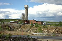
Kristinebergs Pit (2012)

Kristineberg under construction (around 1940)

Kristineberg – Boliden aerial cableway (1943)


Individual evidence
- ↑ a b Statistiska centralbyrån : Småorter 2015, byggnader, areal, överlapp tatorter, coordinater (Excel file)
- ↑ New Boliden website , various materials (Swedish, English)
- ↑ Underground Saint Anne's Church ( Memento of the original from May 3, 2005 in the Internet Archive ) Info: The archive link was automatically inserted and not yet checked. Please check the original and archive link according to the instructions and then remove this notice. on the website of the Church of Sweden Lycksele (Swedish)
Web links
Perpetrator : Hedlunda | Lycksele | Rusksele
Småorter: Åskilje (part) | Betsele | Björksele | Bratten | Kattisavan | Pinch | Kristineberg | Lyckan | Östra Örträsk | Tannsele | Tuvträsk | Umgransele | Vormsele