La Hulpe
| La Hulpe | ||
|---|---|---|

|

|
|
|
|
||
| State : |
|
|
| Region : | Wallonia | |
| Province : | Walloon Brabant | |
| District : | Nivelles | |
| Coordinates : | 50 ° 44 ′ N , 4 ° 29 ′ E | |
| Area : | 15.60 km² | |
| Residents: | 7343 (Jan. 1, 2019) | |
| Population density: | 471 inhabitants per km² | |
| Post Code: | 1310 | |
| Prefix: | 02 | |
| Mayor: | Christophe Dister ( MR ) | |
Local government address : |
Administration communale rue des combattants, 59 1310 La Hulpe |
|
| Website: | www.lahulpe.be | |
La Hulpe ( Dutch Terhulpen , Walloon L 'Elpe ) is a place in the French-speaking province of Walloon Brabant in Belgium , about 20 km southeast of Brussels . It is right on the language border with Flanders .
The name of La Hulpe is of Celtic origin: Helpe means silver river. Hence the stream that flows through the municipality is also called l'Argentine.
economy
The international cooperative SWIFT (Society for Worldwide Interbank Financial Telecommunication) is based in La Hulpe.
Since 2008 the EAMER headquarters of the Kodak 's Graphic Communications Group has been located in La Hulpe.
Attractions
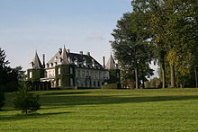
Domaine Solvay and La Hulpe Castle
The estate, classified as an important cultural asset of Wallonia, made up of a landscape park well worth seeing and part of the Soignes forest, is an ornate setting for the castle of La Hulpe, built around 1840. At the end of the 19th century, the chemist Ernest Solvay bought the estate that today belongs to the Walloon Region. In contrast to the castle, the surrounding park is open to the public all year round.
Web links
- Domaine de Solvay - Castle of La Hulpe at the Tourist Office of Wallonia and Brussels (visited October 2, 2008)
- Official website of La Hulpe (French)


