Lank (mountain)
| Lank | ||
|---|---|---|
|
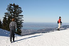
View from below the old Lanklift (drag lift) to the Lank and the ski run on the Schwarzenberg side |
||
| height | 1370 m above sea level A. | |
| location | Vorarlberg , Austria | |
| Mountains | Hochälpele-Weißenfluh Group , Bregenz Forest Mountains | |
| Coordinates | 47 ° 24 '34 " N , 9 ° 48' 22" E | |
|
|
||
| Normal way | from Bödele , Losenpass
|
|
The Lank (earlier spelling: Lanck) is an inconspicuous, 1370 m above sea level. A. high mountain in the Bregenz Forest Mountains , which is located on the municipality border between the two Austrian municipalities Dornbirn ( District Dornbirn ) and Schwarzenberg in the Bregenz Forest ( District Bregenz ). The Lank also forms part of the geographical border between the Rhine Valley and the Bregenzerwald.
Topography, geography, location and traffic
The Lank is about 5 km as the crow flies east of the center of the city of Dornbirn and about 3.6 km from the center of Schwarzenberg. To the southeast located Hochälpelehütte ( 1460 m above sea level , Hochälpelekopf , 1463 m above sea level ) it is about 900 m and to the north located Losenpass ( 1139 m above sea level ) about 1400 m.
About 150 m south-east of the Lankkreuz is the mountain station of the Lanklift (four-seater chairlift of the Dornbirner Seilbahngesellschaft) at 1390 m above sea level. A. The Lankhütte is to the north, about 400 m below the Lankkreuz at about 1230 m above sea level. A.
Around 600 m east of the Lankkreuz at Hinter Lank in the Schwarzenberg municipality is the Lankkluppo parcel (about 1282 m above sea level , also ironically popularly referred to as the Swabian trap ) right next to the Seeblicklift (ski lift of the Hochälpele Schiliftgesellschaft). The Lankzimmer parcel is a few meters above it (about 1305 m above sea level )
About 700 m northwest of the Lankkreuz on the Dornbirn municipality, in the middle of the forest, is the Lanksgrueb parcel (about 1165 m above sea level ). Am Lank denotes a parcel of land about 2 hectares in size, located below the Lankkreuz north to northwest , which lies on both Dornbirn and Schwarzenberg municipal areas, whereby that on the Dornbirn side is almost entirely wooded and that on the Schwarzenberg side is part of the ski slope (in summer Pasture ).
Waters
To the west below the Lank, between the Fallenberg (right) and Kehlegg (left), the Badbach rises (see Bad Kehlegg ) and a little further north the Steinebach and begins the valley of the same name . To the north, about 500 m below the summit cross, the Rothenbach rises, which among other things irrigates the Fohramoos and flows into the Schwarzach after 4.65 km in the Schwarzachtobel .
hike
The mountain requires little surefootedness and is easy to reach. Alpine equipment is not required, but good mountain boots. The closest hiking base is the Hochälpelehütte.
The ascent to the Lank is possible on several routes, e.g. B. from the Losenpass over the ski slope or from the valley station of the Hochälpelelift over the Hinter Lank (Seeblicklift) or from the Hochälpelehütte. The shortest and easiest way leads from the Losenpass southwards over the ski slope.
An alternative route of the European long-distance hiking trail E4 (Northern Alpine Trail 01 / Austrian long-distance hiking trail 01 , section Bregenz - Bödele - Hoher Freschen - Damüls ) leads over the Lank to Dornbirn.
summer
The way from the Losenpass over the goods roads and the ski slope below the Lank to the mountain top is relatively easy and can be easily mastered in about 3/4 hour (231 meters in altitude ). Caution is advised in the grassy slopes when it is wet and frosty. During the alpine season in summer, the grazed cattle are only slightly supervised and move around freely.
winter
In winter, the ascent usually takes place at the edge of the piste via the so-called forest run (piste no.6), provided that the chairlift is not used, and this route is also popular for visiting the Hochälpelehütte (sometimes even at night - attention: snow groomers operate!) . In terms of mountain technology, there are no great demands on the Lank, even in winter, and there is no danger of avalanches .
Climbing aids
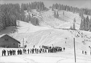
The first motorized ascent aid for skiers went into operation on the Lank in 1908 (see: Bödele sledge lift ). The first T-bar lift on Bödele was built here in 1950 and put into operation in 1951, and since 2000 the first chairlift on Bödele has been transporting skiers to 1,390 m above sea level.
literature
- Dieter Seibert : Bregenzerwald and Lechquellen Mountains. Alpine Club Guide alpine. 1st edition. Bergverlag Rother, Munich 2008, ISBN 978-3-7633-1095-1 , p. 80 .
- Alpenhotel Bödele (Ed.): The Bödele near Dornbirn. Dornbirn undated (probably 1908) online .
Web links
Individual evidence
- ↑ In 1968 the forest run on the Lank was significantly widened as a ski slope through felling (Vorarlberger Nachrichten of November 26, 1968).
- ↑ Constructed by Ing.Hugo Rhomberg and Ing.Alfred Rüsch, the sledge was guided next to the jump track. The elevator sled was attached to a 70 m long hemp rope that was pulled by a 4.5 HP vehicle engine. The ski jumpers could ride while sitting on two benches. Delivery rate approx. 40 jumpers per hour (quoted from Vorarlberger Nachrichten of January 28, 1975, page 7).
- ↑ Lifts in the world - 4-CLF Lank. August 15, 2003, accessed February 17, 2019 .


