Latemarspitze
| Latemarspitze | ||
|---|---|---|
|
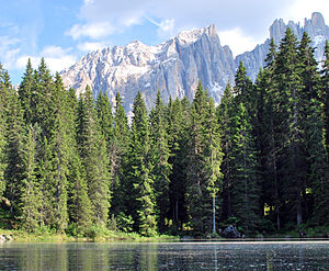
View of the Latemarspitze (center) from Lake Karersee |
||
| height | 2800 m slm | |
| location | South Tyrol , Trentino ( Italy ) | |
| Mountains | Latemar , Dolomites ( Eastern Alps ) | |
| Dominance | 0.55 km → Diamantiditurm | |
| Notch height | 185 m | |
| Coordinates | 46 ° 22 '59 " N , 11 ° 34' 56" E | |
|
|
||
| rock | Sciliar dolomite | |
| First ascent | 1884 | |
|
From the Great Latemarscharte |
||
|
From the west ( Diamantiditurm ) |
||
The Latemarspitze (also Eastern Latemarspitze , Italian Schenon ) is 2800 m slm one of the largest surveys of Latemarmassivs in the Italian Dolomites and is thus part of the World Heritage Dolomites .
Location and surroundings
The Latemarspitze lies in the main ridge of the Latemar, which forms the border between the autonomous provinces of South Tyrol in the north and Trentino in the south. It is located east of the 2650 m high Great Latemarscharte ( Forcella Latemar Grande ), which separates it from the Latemar Towers ( Campanili del Latemar ) with the highest elevation of the massif, the Diamantiditurm ( 2842 m ). The ridge continues towards the east to the 2791 m high Cornon. To the north, the mountain falls in steep, approximately 700-meter-high cliffs to the extensive scree of the Geplänk above Lake Karersee . On the south side of much flatter outweigh debris and craggy ground above the Valsorda , of a side of the Fiemme . Like the entire Latemar , the Latemarspitze consists of clearly stratified Schlern dolomite , the pronounced gullies and gorges on the side of the mountain are largely due to highly eroding igneous rock .
The summit cross of the Latemarspitze, visible from the valley, stands a little northwest of the actual summit on a small pre-summit on the edge of the steep northern slopes.
Bases and paths
As the only one of the high mountains of the Latemar, the Latemarspitze is accessible by marked hiking trails and is therefore one of the most frequently visited mountains in the massif. The Latemarspitze can be reached from the east via a marked alpine trail. The starting point for this tour are the Karersee holiday complex in the municipality of Welschnofen or the Karer Pass ( 1745 m ). From the west, a path leads from the Große Latemarscharte over the southwest flank to the summit. Access is possible from Obereggen , a fraction of the municipality of Deutschnofen, or from the Reiterjoch ( 1983 m ).
The only managed refuge in the area is the Rifugio Torre di Pisa (also Latemarhütte , 2671 m ) in the western Latemar massif. In addition, two bivouac boxes are available with the Bivacco Rigatti ( 2620 m ) on the Große Latemarscharte and the Bivacco Latemar A. Sieff ( 2365 m ) south of the Diamantiditur tower .
history
The Latemarspitze was of the Augsburg Alpinists September 1, 1884 Gustav Euringer with the mountain guide Battista Bernard first climbed . Euringer considered the mountain to be the highest point of the Latemar massif and only recognized his mistake at the summit, whereupon he climbed the actually highest Diamantidi tower for the first time a year later. Euringer climbed the Latemarspitze over the steep north side through a difficult and steep gully . This ascent was rarely repeated and the easier route through the southern flank soon began to take hold.
Web links
- Schenon / Eastern Latemarspitze on Summitpost.org
Individual evidence
- ↑ Alfonso Bosellini: Geology of the Dolomites . Athesia, Bozen 1998, ISBN 88-7014-921-8 , p. 104-105 .
- ↑ Theodor Christomannos : The Latemargruppe . In: German and Austrian Alpine Club (ed.): Journal of the German and Austrian Alpine Club . Bruckmann, Munich 1900, p. 310-311, 312-315 ( anno.onb.ac.at [accessed on August 11, 2010]).


