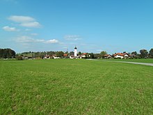
Lauterbach (Rohrdorf)
Lauterbach is a part of the municipality of Rohrdorf in the district of Rosenheim , administrative district of Upper Bavaria .
Geographical location
The districts of Rohrdorf are in the Chiemgau foothills southeast of the city of Rosenheim , all east of the Inn . Lauterbach lies northeast of the village center of Rohrdorf and south of the municipality of Riedering and the Simssees .
history
Lauterbach is mentioned for the first time in a document in 788 in the Notitia Arnonis , a list of all goods and possessions of the Church of Salzburg on ducal Bavarian territory on the occasion of the incorporation of Bavaria into the Frankish empire of Charlemagne . Mentioned therein numerous other towns and the villages Rohrdorf and Höhenmoos , which at the time also been Kirchdörfer were. The place names at that time were: Lutrinpah , Rordorf and Huinmos .
On January 1, 1972, the previously independent municipality of Lauterbach with its 5.63 km² area and its districts Lauterbach, Esbaum , Haslach , Schaurain and Immelberg was incorporated into the municipality of Rohrdorf as part of the Bavarian regional reform. At that time the village had 459 inhabitants.
Demographics
| year | population | Remarks |
|---|---|---|
| 1817 | 89 | in 16 residential buildings, counted in 1817 in the Deanery Söllhuben |
| 1824 | 94 | 23 families, 17 houses, counted in the administrative year 1823/24 of the Isarkkreis |
| 1840 | 216 | |
| 1861 | 210 | |
| 1880 | 199 | |
| 1900 | 222 | |
| 1905 | 249 | |
| 1910 | 250 | |
| 1919 | 234 | |
| 1925 | 241 | |
| 1933 | 243 | |
| 1939 | 232 | , according to other information 233 inhabitants |
| 1946 | 238 | |
| 1950 | 361 | Admission of displaced persons |
| 1952 | 333 | |
| 1972 | 459 | on January 1, 1972, date of incorporation |
traffic
From Lauterbach country roads lead to Rosenheim , Höhenmoos , Achenmühle and Riedering . Lauterbach has a stop on the DB bus line 9493 Roßholzen - Törwang - Lauterbach - Rosenheim . The road network is connected to the federal motorway 8 via the Rohrdorf district of Achenmühle and via the motorway access in Rohrdorf . The distance to Munich via the motorway is approx. 70 km, to Salzburg approx. 85 km.
Attractions
The Catholic village church of St. Johann Baptist in Lauterbach is a late Gothic building with an onion dome .
literature
- Sebastian Dachauer : Chronicle of Brannenburg and the nearest places in the area (continued). In: Upper Bavarian Archive for Fatherland History (Historischen Verein von Oberbayern, Ed.), Volume 4, Munich 1843, Section 9: Contributions to the Chronicle of the Parish Rordorf , pp. 244–270, especially p. 250 ( online ).
- Hans Riedler: Rohrdorf / Obb. A local history , 1980 (279 pages).
- Hans Riedler: Rohrdorf / Obb. A local history. Volume 2 , 1997 (471 pages).
Web links
- Rohrdorf municipality
- Entry on the coat of arms of Lauterbach (Rohrdorf) in the database of the House of Bavarian History
Individual evidence
- ^ Arno von Salzburg : Indiculus Arnonis and Brevis notitiae Salzburgenses . Salzburg, approx. 790; reissued by known and after previously unused manuscripts and accompanied by remarks by Friedrich Keinz, Munich 1869, p 22 .
- ^ Sebastian Dachauer : Chronicle of Brannenburg and the nearest places in the area . Section 9: Contributions to the chronicle of the parish Rordorf . In: Upper Bavarian Archive for Fatherland History (Historischen Verein von Oberbayern, Ed.), Volume 4, Munich 1843, pp. 250-251 ( online) .
- ^ Federal Statistical Office (ed.): Historical municipality directory for the Federal Republic of Germany. Name, border and key number changes in municipalities, counties and administrative districts from May 27, 1970 to December 31, 1982 . W. Kohlhammer GmbH, Stuttgart / Mainz 1983, ISBN 3-17-003263-1 , p. 588 .
- ↑ a b c Hans Riedler: Rohrdorf / Obb. Eine Ortsgeschichte , 1980, pp. 263–264.
- ↑ Martin von Deutinger : Tabular description of the Diocese of Freysing according to the order of the Decanate , Munich 1820, p. 486 ( online ),
- ↑ Deutinger, loc. cit., Vorerinnerung , p. VII
- ↑ Adolph von Schaden : Alphabetical directory of all the cities, markets, villages, hamlets, wastelands, etc. located in the Isar district (as an appendix to the topographical = statistical manual for the Isar district of the Kingdom of Baiern, e-copy ), Munich 1825, p. 281 ( online )
- ↑ Adolph von Schaden : Topographisch = Statistical Handbook for the Isar Circle of the Kingdom of Bavaria , printed and published at the expense of the Königl. Government of the Isarkkreis, Munich 1825 ( online ).
- ↑ a b c d e f g h i j k l Historical municipality directory - the population of the municipalities of Bavaria from 1840 to 1952 , issue 192 of the articles on Statistics Bavaria, published by the Bavarian State Statistical Office, Munich 1953, p. 39 ( online, MDZ ).
- ^ A b M. Rademacher: German administrative history from the unification of the empire in 1871 to the reunification in 1990. City and district of Rosenheim (online material for the dissertation, Osnabrück 2006)
Coordinates: 47 ° 49 ' N , 12 ° 11' E


