Les Valls de Valira
| Municipality of Les Valls de Valira | ||
|---|---|---|
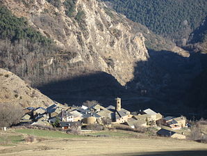
 Ars - the townscape
|
||
| coat of arms | Map of Spain | |

|
|
|
| Basic data | ||
| Autonomous Community : |
|
|
| Province : | Lleida | |
| Comarca : | Old Urgell | |
| Coordinates | 42 ° 27 ' N , 1 ° 24' E | |
| Height : | 740 msnm | |
| Area : | 169.44 km² | |
| Residents : | 791 (Jan. 1, 2019) | |
| Population density : | 4.67 inhabitants / km² | |
| Postal code : | 25798 | |
| Municipality number ( INE ): | 25239 | |
| administration | ||
| Website : | Les Valls de Valira | |
Les Valls de Valira is a municipality ( municipality ) with 791 inhabitants (as of January 1, 2019) in the province of Lleida in the autonomous region of Catalonia . The municipality includes the 15 villages of Anserall, Arcabell, Arduix, Argolell, Ars , Asnurri, Baixos de Calbinyà, Bescarán, Calbinyà, Civis, Farga de Moles, Os de Civís, Sant Antoni, Sant Joan Fumat and Sant Pere .
location
The places of the municipality, framed by the wooded mountains of the southern Pyrenees, are located at altitudes of about 700 to 1150 meters above sea level. d. M. in north-west Catalonia near the border with Andorra . Some mountain peaks such as El Monturull reach heights of over 2000 meters. Parts of the municipality are traversed by the Riu Valira .
Population development
| year | 1970 | 1981 | 1990 | 2001 | 2011 |
| Residents | 851 | 765 | 818 | 739 | 907 |
In the middle of the 19th century, the formerly independent villages had a total of around 2,000 inhabitants. The mechanization of agriculture and the associated loss of jobs have since led to a constant decline in the population.
economy
In the past, the residents lived mainly as self-sufficient farmers from dairy farming and cheese-making . In the meantime, many vacant houses have been converted into holiday apartments.
history
In the Middle Ages, large parts of today's municipal area belonged to the manor of the Counts of Urgell . The municipality was created in 1970 through the merger of initially only five villages ( Anserall , Arcabell , Ars , Bescarán and Civis ). In the course of time the other villages were added.
Attractions
There are several listed buildings in the commune ( Béns Culturals d'Interès Nacional or ... Local ):
- Anserall
From from rubble built Mosteiro Sant Serni de Tavèrnoles only the eastern parts of the church (are apses and transept ) received; only remains of the wall of the single nave nave . Since the two transept arms also end in apses, there is perhaps a connection to the group of Trikonchos churches (cf. Sant Pere de Montgrony ).
- Argolell
The single-nave parish church of Santa Eugenia is a non-vaulted building from the 11th century with a wooden roof and a right-angled apse. The frescoes were removed at the beginning of the 20th century and are located in the Museu Nacional d'Art de Catalunya (MNAC) in Barcelona .
- Ars
The village of Ars , with only about 30 inhabitants, impresses with its location and the round tower of the Sant Martí church from the 12th century.
- Asnurri
The church of Santa Eulalia is a building made of rubble stones with a tower on the south side.
- Bescarán
The free-standing bell tower ( campanar ) of the now defunct church of Sant Martí , which rises on a square floor plan, impresses with its height and its window and sound openings that open more and more upwards.
- Civis
The church of Sant Romà is also a Romanesque building from the 12th century.
Web links
Individual evidence
- ↑ Cifras oficiales de población resultantes de la revisión del Padrón municipal a 1 de enero . Population statistics from the Instituto Nacional de Estadística (population update).


