Letefoho
| Letefoho | ||
|---|---|---|
|
|
||
| Coordinates | 8 ° 50 ′ S , 125 ° 26 ′ E | |

|
||
| Basic data | ||
| Country | East Timor | |
| Ermera | ||
| Administrative office | Letefoho | |
| ISO 3166-2 | TL-ER | |
| Suco | Main | |
| height | 1533 m | |
|
Letefoho Church
|
||
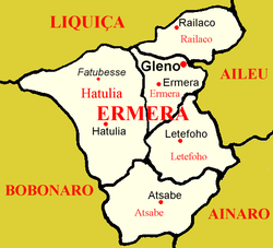
Letefoho ( Lete Foho, Lete-Foho, Letefuó ) is the capital of the East Timorese administrative office Letefoho ( municipality of Ermera ). Portuguese colonial buildings stand here together with traditional huts.
In 1936, Letefoho was renamed Nova Óbidos by the Portuguese . But the name did not catch on and a few years after the Second World War , the old name was reverted to.
geography
The place Letefoho is at an altitude of 1533 m above sea level in Suco Haupu . The place name means mountain peak , accordingly Letefoho lies on the dome of a hill. To the municipal capital Gleno it is about 13 km as the crow flies to the north, to the state capital Dili about 35 km to the northeast.
After the violence surrounding the independence referendum of 1999, Letefoho had to be largely rebuilt, mostly with unimaginative modern buildings and smaller traditional elements of the Mambai culture. Some buildings from the Portuguese colonial era can still be found. The church Igreja de Nossa Senhora do Carmo dominates the place with a tower, the top of which reminds of two hands folded in prayer.
Letefoho has a pre-school, a primary school, a pre-secondary school ( Escola Pre-Secondaria No. 705 Letefoho Villa / Haupu ), a helipad and a community health center.
history
During the Manufahi War , Letefoho was captured by the Portuguese on October 26, 1900, as an ally of the rebellious Manufahi . In 1903 another Letefoho uprising against the Portuguese colonial rulers failed.
On May 3, 1976, the Indonesian battalion 512 reached Letefoho. They began killing people in the town and neighboring villages, which is why civilians fled into the woods. In Catraileten , at the foot of the Tatamailau , a resistance base ( base de apoio ) was built, in which thousands of civilians sought protection under the FALINTIL . Here they could farm and thus secure their basic supplies. The base was encircled and destroyed by the Indonesians on May 18, 1978. The Indonesian armed forces shelled the base with mortars, bazookas and artillery. Aircraft bombed the positions. Landmines killed many people. Those who could not escape were taken to Letefoho.
Those who escaped fled to Lesemau , where they found little food in the woods. Indonesian planes sprayed toxins that settled on edible plants and got into drinking water. About 400 people died because they drank the poisoned water or ate wild plants. Even tubers that grew 15 cm below the surface were poisoned. Of the members of the Aldeia Catrai Caraic , all but one woman and her granddaughter died. The survivors fled to Hatulete (Suco Catrai Caraic). There they were eventually captured by Indonesian Battalion 512 and members of the Civil Defense ( Hansip ). The prisoners were taken to the Letefoho Detention Center.
Sons and daughters
- Angélica da Costa (* 1967), East Timorese politician
- Domingos Maria Sarmento (* 1955), East Timorese politician
Individual evidence
- ↑ Tour de Timor: Explore Dili and Districts ( Memento of the original from July 10, 2015 in the Internet Archive ) Info: The archive link has been inserted automatically and has not yet been checked. Please check the original and archive link according to the instructions and then remove this notice. , accessed July 9, 2015.
- ↑ Geoffrey Hull : The placenames of East Timor , in: Placenames Australia (ANPS): Newsletter of the Australian National Placenames Survey, June 2006, pp. 6 & 7, ( Memento of the original from February 14, 2017 in the Internet Archive ) Info: The archive link was inserted automatically and has not yet been checked. Please check the original and archive link according to the instructions and then remove this notice. accessed on September 28, 2014.
- ^ João Soares: Novo Atlas Escolar Português , 5th updated edition, Lisboa 1954
- ^ Unofficial Guide to East Timor
- ↑ List of polling stations for the parliamentary elections in East Timor 2007 (PDF file; 118 kB)
- ↑ UNMIT: Timor-Leste District Atlas version 02, August 2008 ( Memento of the original from November 8, 2012 in the Internet Archive ) Info: The archive link has been inserted automatically and has not yet been checked. Please check the original and archive link according to the instructions and then remove this notice. (PDF; 535 kB)
- ^ Frédéric B. Durand: History of Timor-Leste, p. 70, ISBN 978-616-215-124-8 .
- ↑ History of Timor - Technical University of Lisbon ( Memento of the original from March 24, 2009 in the Internet Archive ) Info: The archive link was automatically inserted and has not yet been checked. Please check the original and archive link according to the instructions and then remove this notice. (PDF; 824 kB)
- ↑ a b c CAVR Chega Files: Part 7.3: Forced Displacement and Famine ( Memento of the original from November 28, 2015 in the Internet Archive ) Info: The archive link was inserted automatically and has not yet been checked. Please check the original and archive link according to the instructions and then remove this notice. (PDF; 1.3 MB)


