Lich-Steinstrasse (Niederzier)
|
Lich-Steinstrasse
Niederzier municipality
|
|
|---|---|
| Coordinates: 50 ° 56 ′ 5 ″ N , 6 ° 29 ′ 9 ″ E | |
| Height : | approx. 87 m |
| Area : | 18.06 km² |
| Residents : | 0 |
| Population density : | 0 inhabitants / km² |
| Incorporation : | January 1, 1972 |
|
Location of the former place Lich-Steinstrasse in the Rhenish lignite district
|
|
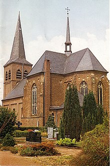
Lich-Steinstrasse was the northernmost part of the municipality Niederzier in the district of Düren . Until the beginning of the resettlement, 1473 inhabitants lived in 393 properties in the village. Lich-Steinstrasse was known for the fact that some showmen and so-called Moppenbäcker lived in the village .
location
The double village Lich-Steinstrasse consisted of Lich to the north and Steinstrasse to the south on federal road 55 , the old Roman Via Belgica . Both places had grown together. Lich-Steinstrasse was north of the Bürgewald , today often incorrectly referred to as the Hambach Forest, and the Great Forest (eastern part of the actual Hambach Forest), at the northern end of the aisle between the two forests. The state road 12 crossed the place and led south to Hambach and north to Rödingen . The federal road 55 through Steinstrasse led in a westerly direction to Stetternich and in an easterly direction to Elsdorf . Other neighboring towns were Höllen , Bettenhoven , Oberembt in the north and Tollhausen and Esch in the east.
General
Lich-Steinstrasse is now partly a desert . The place formed the municipality of Steinstrasse with an area of 18.48 km² and 1504 inhabitants on the last day of his independence, December 31, 1971. Since January 1, 1972, Lich-Steinstrasse has belonged to the municipality of Niederzier in the Düren district and had to in the years 1981 to In 1990 the northern area of the Hambach opencast mine gave way. Part of the location of Lich still exists, but is located directly on the northern edge of the open pit. The Steinstrasse south of this ridge was completely excavated. In 2006 the Rheinbraun tipped over the remaining locality of Lich overburden . Only parts of the Prämienstraße (L 12), which leads in the direction of Rödingen , and a small remnant of the Herrenstraße are visible . Between the two parallel streets there has been a motocross track of the MSC-Arnoldsweiler since 2006 on the former excavation site of the Rheinbraun. A lookout point was located at the site of the former parish church for several years until 2006.
In 1978, the Rhineland Regional Council documented the preparations and implementation of the Corpus Christi procession in Lich-Steinstrasse in a film.
history
In the population list of the year 1799, Lich and Steinstrasse together show 852 inhabitants and a stock of 167 houses, making the twin town the largest settlement in the current territory of the Niederzier community.
Relocation
The new Lich-Steinstrasse was built as a new location on the outskirts of Jülich from 1979.
Bürgewald
Lich belonged to the so-called Bürgewald communities that owned the rights to the Bürgewald . According to the legend, this is due to the holy Arnold von Arnoldsweiler , for the legendary "Ride around the Bürgewald". The main town of the Bürgewald communities is Arnoldsweiler . There the Lichers had to offer a candle to Saint Arnold on Whit Tuesday, later on Whit Monday. This wax interest was only canceled in the 19th century.
church
literature
- Leo de Jong: Captive Home , Stetternich 1972
- Gabriele Nickel-Peltzer: The old village - the new suburb , Cologne 1992
- Ewald Glässer, Hartwig Arndt: Structure and modern development of the settlements on the left bank of the Rhine in the Hambach opencast mining area with special consideration of the town of Lich-Steinstrasse , Cologne 1978
Web links
Individual evidence
- ↑ Short chronology of resettlement. (pdf) (No longer available online.) RWE , archived from the original on April 4, 2016 ; accessed on April 13, 2017 .
- ^ Federal Statistical Office (ed.): Historical municipality directory for the Federal Republic of Germany. Name, border and key number changes in municipalities, counties and administrative districts from May 27, 1970 to December 31, 1982 . W. Kohlhammer, Stuttgart / Mainz 1983, ISBN 3-17-003263-1 , p. 306 .
- ^ LVR Institute for Regional Studies and Regional History (ed.): Corpus Christi in Steinstraß-Lich , 1978.
- ^ Kaulen, Heinz / Dürener Geschichtsverein: The population and social structure of the places of today's municipality Niederzier in the year 1799 - reproduction and evaluation of the population lists from French times. Contributions to the history of the Dürener Land, Volume 26, Dürener Geschichtsverein, Düren, 2006 (pp. 17, 20).
- ↑ Document from 1360 to confirm the wax interest, by the Duke of Jülich.


