
List of architectural monuments in Creußen

The monuments of the Upper Franconian town of Creußen are compiled on this page . This table is a partial list of the list of architectural monuments in Bavaria . The basis is the Bavarian Monument List , which was first drawn up on the basis of the Bavarian Monument Protection Act of October 1, 1973 and has since been managed by the Bavarian State Office for Monument Preservation . The following information does not replace the legally binding information from the monument protection authority. This list reflects the update status from January 8, 2015 and contains 76 monuments.
Ensembles
Ensemble old town Creußen

more pictures
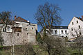
The ensemble ( location ) comprises the city surrounded by a fortification and the immediately adjacent suburban areas on the sandstone spur above the Red Main . In terms of settlement history, Creußen is characterized by the connection between castle and town on a high plateau within a common fortification ring. The place, which was already marked in its settlement form on the occasion of its first mention in 1003, can be counted among the Ottonian state castles, administrative centers of sub-areas that have a mixed form of castle and town. The place was raised to a city in 1358. The walled city has a square plan. The gradually rising street of the suburbs leads to the main gate in the southeast corner. The settlement is grouped around a central square, which widens in a triangular shape. The elongated Habergasse runs parallel to its western long side, which in its overall shape and the free position of the town hall in its center identifies itself as a former street market. In the area of the current rectory there was the lost inner castle. In the east of the city, on a lower terrace, the self-contained church district is attached. Creußen suffered extensive destruction in a fire in 1893, especially in the area of Habergasse, on the market square and the old town hall; it was rebuilt at the end of the 19th century. The parceling structure suggests a closed row of townhouses and craftsmen's houses in the gable position before the city fire, an arrangement that has been partially preserved on Rennsteig and Vestgasse. Part of the ensemble are widespread cellars driven into the sandstone. A distinction must be made between multi-storey cellars, usually tied to a parcel, and branched corridor systems that are independent of the above-ground parcel structure. The latter are divided into development and secondary tunnels. Individual tunnels end in ice hollows, and some supports for barrels have been preserved. File number: E-4-72-127-1.
City fortifications
The city fortifications ( location ) have been preserved throughout, built after the city was founded in 1358, renewed in the 70s of the 15th century, after the middle of the 16th and after the middle of the 17th century. The castle area (removed), the parish and the actual city are united within the wall ring. It is a simple move of the wall accompanied by towers, the main entrance (front gate in the southeast corner) was removed after 1893. The south wall extending from this point runs behind the property Marktplatz 1 ( location ), Am Rathaus 1, 3, 5, 7 (there also semicircular tower ( location )), 9, 11, 13, 15 (there also the round southwest corner tower) , the western walling at the properties Am Rathaus 15 (with the opening of the Häfnertore ( location )), 17, 19, 21, 23 (there the opening of the mill door ( location )), Habergasse 1, 3, 5, 7, 9, 11, 13, 15, 17, 19, 21 (there also the round northwest corner tower), 23 (with rear gate, labeled "1601"), the northern part of the fortification runs at the properties Am Rennsteig 2, 4, 6, 8, Marktplatz 18, 20 (there also a semicircular tower), 22, Heziloplatz 1 (round northeast corner tower, labeled "1474"), the east extension of the fortification at Heziloplatz 2 (there is a semicircular tower), Marktplatz 2, 4, 6, 8, 10 , 12, the lower lying church district (Pfarrer-Will-Platz), which is attached to the city in the north-west, has its own walling to the north and west. File number: D-4-72-127-1.
southern wall at Marktplatz 1

southern wall at Am Rathaus 7, 5, 3, 1
more pictures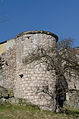
Wall tower at Am Rathaus 7
more pictures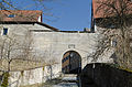
Häfnertor, field side
more pictures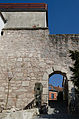
Mill door, field side
more pictures
Wall tower at Marktplatz 20
more pictures
Wall tower at Heziloplatz 2
more pictures


| location | object | description | File no. | image |
|---|---|---|---|---|
| Am Rennsteig 8 ( location ) |
Back gate | Hipped roof building with passage and upper floor, marked "1601" | D-4-72-127-32 |
 more pictures |
| Near the old town hall ( location ) |
Southwest corner tower of the city fortifications | Round tower, sandstone ashlar masonry, hipped roof, mid-14th century to mid-17th century | D-4-72-127-96 |
 more pictures |
| On the Hintermühlweg; Near Hinterer Torweg; Near Mühltürlein ( location ) |
Northwest corner tower of the city fortifications, so-called hunger tower | Built as a prison, round tower made of sandstone ashlar masonry with a conical roof, mid-14th century to mid-17th century | D-4-72-127-97 |
 more pictures |
| Heziloplatz 1 ( location ) |
North-eastern corner tower of the city fortifications | Sandstone block construction with wood-paneled upper storey and conical roof, inscribed "1474" | D-4-72-127-95 |
 more pictures |
Architectural monuments according to districts
Cussen
| location | object | description | File no. | image |
|---|---|---|---|---|
| Am Alten Rathaus 4 ( location ) |
Heraldic relief | Sandstone, inscribed "1609" | D-4-72-127-4 |
 more pictures |
| Am Alten Rathaus 6 ( location ) |
Old Town Hall | Two-storey saddle roof building with ridge turret, restored around 1470, 1652–1679, coat of arms on the late Gothic portal on the south side, meat and bread banks in the eastern long side preserved | D-4-72-127-6 |
 more pictures |
| Am Alten Rathaus 9 ( location ) |
Residential building | Two-storey, gable-independent gable roof building, marked "1848" | D-4-72-127-9 |
 more pictures |
| Am Alten Rathaus 12 ( location ) |
Amschler House | Residential house, two-storey saddle roof construction, around 1600, attached to the town hall (Am Alten Rathaus 6) | D-4-72-127-2 |
 more pictures |
| Am Alten Rathaus 13 ( location ) |
Residential building | Gable-independent, two-storey saddle roof building, gable sandstone cuboid, inscribed "1808" | D-4-72-127-10 |
 more pictures |
| Am Alten Rathaus 15 ( location ) |
Residential building | Gable-independent, two-storey saddle roof building, 17th century, inscribed "1881" | D-4-72-127-11 |
 more pictures |
| Am Alten Rathaus 25 ( location ) |
Residential building | Single-storey, gable-independent saddle roof structure, walls, half-timbered gable, 18th century | D-4-72-127-13 |
 more pictures |
| Am Hohen Weg 22 ( location ) |
Two memorial stones | At the historic site of the High Court of Creußen, 18th and 20th centuries | D-4-72-127-91 |

|
| Am Rennsteig 6 ( location ) |
Residential building | Gable-independent, two-storey saddle roof construction, marked "1836", gable renewed | D-4-72-127-15 |
 more pictures |
| Am Rennsteig 8 ( location ) |
Residential building | Today the municipal Krügemuseum, two-storey, gable-roof construction, labeled "1770" | D-4-72-127-16 |
 more pictures |
| Bayreuther Straße 2 ( location ) |
Residential building | Two-storey sandstone block construction on a base with a half-hipped roof, cornice, window frames, inscribed "1792" | D-4-72-127-18 |
 more pictures |
| Bayreuther Straße 3 ( location ) |
Residential building | Two-storey hipped roof building, baroque door frames, window frames, around 1800; a sandstone gate pillar | D-4-72-127-19 |
 more pictures |
| Habergasse 4 ( location ) |
Residential building | Two-storey, eaves-standing building made of sandstone blocks with a gable roof, the windows on the upper floor with straight roofs, around 1865/70 | D-4-72-127-21 |
 more pictures |
| Habergasse 14 ( location ) |
Residential building | Single-storey, gable-independent sandstone block building with a gable roof, mid-19th century, over an older core | D-4-72-127-25 |
 more pictures |
| Habergasse 16 ( location ) |
Heraldic relief | Sandstone, inscribed "1739" | D-4-72-127-27 |
 more pictures |
| Habergasse 17 ( location ) |
Residential building | Two-storey, eaves saddle roof construction, sandstone cuboid, around 1800 | D-4-72-127-28 |
 more pictures |
| Habergasse 19 ( location ) |
Residential building | Two-storey, eaves saddle roof construction, sandstone cuboid, around 1800 | D-4-72-127-30 |
 more pictures |
| Heziloplatz 1 ( location ) |
Rectory | Former Palais Schirnding, in the district of the former Creußen Castle , two-storey hipped roof building on a sandstone ashlar base, outside staircase, corner pilasters, portal with curved gable, rusticated, 1753–1764 | D-4-72-127-33 |
 more pictures |
| Heziloplatz 2 ( location ) |
Residential building | Two-story saddle roof building, half-timbered upper floor plastered, 17th / 18th centuries Century, sitting on the city wall and connected with a fortification tower | D-4-72-127-34 |
 more pictures |
| Near Hintermühlweg ( location ) |
A series of cellars with water basins for fish wintering | First half of the 19th century | D-4-72-127-148 |
|
| Marketplace 7 ( location ) |
Heraldic relief | Sandstone, Johann Walther, inscribed "1712" | D-4-72-127-36 |
 more pictures |
| Marktplatz 12 ( location ) |
Heraldic relief | Emblem relief, sandstone, inscribed "1628" | D-4-72-127-38 |
 more pictures |
| Marktplatz 14 ( location ) |
Former brewery | Evangelical-Lutheran parish hall since 1993, single-storey sandstone block building with gable roof, dormer belt, 1806 | D-4-72-127-39 |
 more pictures |
| Marktplatz 16 ( location ) |
Residential building | Two-storey gable roof construction, quarry stone, window frames, 17th / 18th centuries century | D-4-72-127-40 |
 more pictures |
| Marktplatz 20 ( location ) |
Residential building | Two-storey, gable-independent gable roof construction, in the core 17th / 18th centuries century | D-4-72-127-42 |
 more pictures |
| Metzlesberg 1 ( location ) |
Five crypt houses | Small tent roof houses, sandstone blocks, first half of the 19th century, one marked "1827", the Seijhardt family crypt marked "1778" | D-4-72-127-17 |
|
| Near Nürnberger Straße ( location ) |
Row of barns on the former room square | Formerly thirteen, today eleven barns, sandstone cuboid buildings with wooden sliding gates and saddle or half-hipped roofs, around 1800, e.g. Some modern additions | D-4-72-127-100 |
 more pictures |
| Near Nürnberger Strasse; Room place ( location ) |
Two barns of a row of barns formerly consisting of four barns | With half-timbering, saddle roofs and sandstone ashlar bases, around 1800, part of the row of barns around the former room square | D-4-72-127-87 |
 more pictures |
| Neuhofer Straße 2 ( location ) |
Corner house | Two-storey saddle roof building with plastered half-timbered upper storey, 17th / 18th centuries century | D-4-72-127-44 |
 more pictures |
| Neuhofer Straße 4 ( location ) |
Residential building | Eaves, two-story saddle roof building, half-timbered upper floor plastered, 18th century | D-4-72-127-45 |
 more pictures |
| Neuhofer Straße 5 ( location ) |
Hermit's house | Single-storey hipped roof building with half-timbered tower, neo-Gothic and Baroque decor, 1760; with equipment; Sandstone pillar fence and gate, around 1760 | D-4-72-127-46 |
 more pictures |
| Neuhofer Straße 8 ( location ) |
Residential building | Eaves, two-storey saddle roof building with half-timbered gable, essentially 18th century | D-4-72-127-47 |
 more pictures |
| Nürnberger Strasse 1 ( location ) |
Residential building | Two-storey, eaves saddle roof construction, window frames, coat of arms relief, inscribed "1762" | D-4-72-127-48 |
 more pictures |
| Nürnberger Strasse 3 ( location ) |
Residential building | Two-storey, eaves-standing sandstone block structure, gable roof with a half-hip, cornice, inscribed "1827" | D-4-72-127-49 |
 more pictures |
| Nürnberger Strasse 7 ( location ) |
Residential building | Two-storey, gable-independent gable roof construction, marked "1822" | D-4-72-127-50 |
 more pictures |
| Nürnberger Strasse 9 ( location ) |
Residential building | Two-storey, gable roof construction, first half of the 19th century | D-4-72-127-51 |
 more pictures |
| Nürnberger Strasse 10 ( location ) |
Residential building | Two-storey, eaves-standing sandstone block building with hipped roof, central projection, inscribed "1835" | D-4-72-127-52 |
 more pictures |
| Nürnberger Strasse 14 ( location ) |
Duplex | Two eaves, two-storey saddle roof or half hipped roof buildings, late 18th / early 19th century | D-4-72-127-53 |
 more pictures |
| Nürnberger Strasse 16 ( location ) |
Residential building | Eaves, two-story saddle roof building, half-timbered upper floor, 17th century | D-4-72-127-54 |
 more pictures |
| Nürnberger Strasse 18 ( location ) |
Residential building | Eaves, two-storey saddle roof structure, hipped on one side, buttresses, 17th century | D-4-72-127-55 |
 more pictures |
| Nürnberger Strasse 30 ( location ) |
Residential building | Eaves, two-storey half-hipped roof building with cornice, mid-19th century | D-4-72-127-56 |
 more pictures |
| Pfarrer-Will-Platz 1 ( location ) |
Evangelical Lutheran Parish Church of St. James | Formerly St. James the Elder, hall building rebuilt after destruction in 1471–1477, retracted choir 1500, west tower raised in 1567, Welsche dome and lantern 1643, arched passage under the choir, Baroque modification in 1700 by Antonio della Porta , stair tower of the sacristy 1710; with equipment | D-4-72-127-57 |
 more pictures |
| Pfarrer-Will-Platz 4 ( location ) |
Residential building | Two-storey half-hipped roof and saddle roof building on a hillside on the city wall with half-timbered gable, 17th / 18th centuries century | D-4-72-127-58 |
 more pictures |
| Suburb 8 ( location ) |
Residential building | Gable-mounted, two-storey saddle roof building, 18th century | D-4-72-127-60 | |
| Suburb 18 ( location ) |
Residential building | Gable-mounted, two-storey half-hipped roof building, sandstone cuboid, cornices, inscribed "1842" | D-4-72-127-63 |
 more pictures |
| Suburb 20 ( location ) |
Residential building | Two-storey, eaves half-hipped roof building, marked "1803", the core of the 18th century | D-4-72-127-64 |
 more pictures |
| Vorstadt 22 a ( location ) |
Corner house | Two-storey hipped roof building with drilled sandstone walls, marked "1777" | D-4-72-127-65 |
 more pictures |
| Suburb 23 ( location ) |
Residential building | Two-storey eaves-standing sandstone cuboid building with half-hipped roof, rich facade structure with cornice and rusticated corner pilasters, drilled walls, on the upper floor with window aprons, front staircase, inscribed "1788" | D-4-72-127-66 |
 more pictures |
Altenkünsberg
| location | object | description | File no. | image |
|---|---|---|---|---|
| Altenkünsberg 6 ( location ) |
Burgstall | Foundation wall made of quarry stone and sandstone, 13th century | D-4-72-127-69 |
 more pictures |
| Herrnwiese ( location ) |
War memorial | Granite pillar with embedded marble tablet and iron cross, octagonal border, inscribed "1921" | D-4-72-127-101 |
Althaidhof
| location | object | description | File no. | image |
|---|---|---|---|---|
| Althaidhof 11 ( location ) |
Former Althaidhof Palace | Two-storey half-hipped roof building, 1680, over an older core | D-4-72-127-70 |
Buhl
| location | object | description | File no. | image |
|---|---|---|---|---|
| Schloßstraße 9 ( location ) |
Former Bühl Castle | Two-storey, gable-independent half-hipped roof building, east side with half-timbered gable, west side built-in gallery corridor with animal figures (second use), in the core 15th / 16th. Century, coat of arms relief marked 1618; Gate pillar with spherical crown, 18th century | D-4-72-127-71 | |
| St 2184 ( location ) |
Stone cross | Sandstone, a cross arm shortened, 16th century | D-4-72-127-72 |
Bucket mill
| location | object | description | File no. | image |
|---|---|---|---|---|
| Neuenreuth 3 ( location ) |
Mill homestead | Stable house, two-storey sandstone block construction with a gable roof and half-timbered gable, inscribed "1830"; Residential house, two-storey sandstone block construction, upper floor plastered, inscribed "1911", with older parts; Cellar houses made of sandstone, labeled "1832" and "1838" with a lintel from 1798 | D-4-72-127-86 |

|
Gottsfeld
| location | object | description | File no. | image |
|---|---|---|---|---|
| Dorfstrasse 6, at the barn ( location ) |
Remnants of an inscription plaque | Sandstone, inscribed "1513" | D-4-72-127-73 |

|
Großweiglareuth
| location | object | description | File no. | image |
|---|---|---|---|---|
| Großweiglareuth 1 ( location ) |
Discharge house | Two-story saddle roof building, ground floor sandstone cuboid, upper floor and gable with rich half-timbering, inscribed "1835" | D-4-72-127-74 |
Hörhof
| location | object | description | File no. | image |
|---|---|---|---|---|
| Schwarzweiher ( location ) |
Cross stone | Sandstone, probably from the late Middle Ages | D-4-72-127-68 |
Lindenhardt
| location | object | description | File no. | image |
|---|---|---|---|---|
| At the church 5 ( location ) |
Sacristan's house | Two-storey sandstone block building with hipped roof, corner pilaster strips, plastered on the courtyard side, 1767 | D-4-72-127-79 | |
| At the church 9 ( location ) |
Former second rectory | Pedestal, two-storey sandstone block construction with hipped roof, cornice, 1835 | D-4-72-127-78 |

|
| At the church 11 ( location ) |
War memorial | Three stone crosses with names of the fallen, around 1950 | D-4-72-127-103 |

|
| At the church 11; At the church 9 ( location ) |
Evangelical parish church | Late Gothic sandstone block construction with buttresses, retracted choir and west tower with pointed helmet, 14th / 15th century. Century, upper floors of the tower 1860/61, nave second half of the 15th century, choir head beginning of the 16th century; with equipment | D-4-72-127-75 |
 more pictures |
| Graubühl 4 ( location ) |
Former forester's house | Two-storey sandstone block construction with hipped roof, around 1800 | D-4-72-127-76 | |
| Marktstrasse 6 ( location ) |
Rectory | Two-storey sandstone block building with hipped roof, entrance portal with horizontal roofing, 1765, by Johann Gottlieb Riedel ; Sandstone pillar portal with spherical crown | D-4-72-127-77 |

|
Reichholdsweber
| location | object | description | File no. | image |
|---|---|---|---|---|
| Am Hahnensteig ( location ) |
Stone cross | Made of sandstone, left cross arm missing, 16th century | D-4-72-127-67 |
Schwürz
| location | object | description | File no. | image |
|---|---|---|---|---|
| Schwürz 10 ( location ) |
Discharge house | Two-story saddle roof building, ground floor sandstone cuboid, upper floor and gable with rich half-timbering, inscribed "1819" | D-4-72-127-81 |
Seidwitz
| location | object | description | File no. | image |
|---|---|---|---|---|
| Hauptstrasse 22 ( location ) |
Inn | Two-storey, gable-independent half-hipped roof building with a baroque portal, inscribed "1827" | D-4-72-127-83 | |
| Tiefenthaler Straße 7 ( location ) |
Evangelical branch church | Plastered hall building with hipped roof and choir tower , western nave 1649, eastern nave and choir tower with helmet and lantern 1744 by Johann David Räntz; with equipment | D-4-72-127-82 | |
| Tiefenthaler Straße 7 ( location ) |
War memorial | Three stone tablets, the middle one with a triangular gable and an iron cross, first half of the 20th century | D-4-72-127-104 |
Tiefenthal
| location | object | description | File no. | image |
|---|---|---|---|---|
| Tiefenthal 8 ( location ) |
Former watermill | Two-storey saddle roof building with half-timbered gable, marked 1804 with mill wheel, coat of arms relief, marked "1570" | D-4-72-127-84 |
Unterhöhlmühle
| location | object | description | File no. | image |
|---|---|---|---|---|
| Cave mill 3; Fichtenohe ( location ) |
Former mill | Two-storey saddle roof construction, ground floor sandstone cuboid, upper storey half-timbered, inscribed "1883"; overshot mill wheel, 19th century | D-4-72-127-85 |
See also
Remarks
- ↑ This list may not correspond to the current status of the official list of monuments. The latter can be viewed on the Internet as a PDF using the link given under web links and is also mapped in the Bavarian Monument Atlas . Even these representations, although they are updated daily by the Bavarian State Office for Monument Preservation , do not always and everywhere reflect the current status. Therefore, the presence or absence of an object in this list or in the Bavarian Monument Atlas does not guarantee that it is currently a registered monument or not. The Bavarian List of Monuments is also an information directory. The property of a monument - and thus the legal protection - is defined in Art. 1 of the Bavarian Monument Protection Act (BayDSchG) and does not depend on the mapping in the Monument Atlas and the entry in the Bavarian Monument List. Objects that are not listed in the Bavarian Monument List can also be monuments if they meet the criteria according to Art. 1 BayDSchG. Early involvement of the Bavarian State Office for Monument Preservation according to Art. 6 BayDSchG is therefore necessary in all projects.
literature
- Denis André Chevalley: Upper Franconia . Ed .: Michael Petzet , Bavarian State Office for the Preservation of Monuments (= Monuments in Bavaria . Volume IV ). Oldenbourg, Munich 1986, ISBN 3-486-52395-3 .
Web links
- Bavarian Monument Atlas (cartographic representation of the Bavarian architectural and ground monuments by the BLfD , requires JavaScript)
- List of monuments for Creußen (PDF) at the Bavarian State Office for Monument Preservation (PDF; 142 kB)

Maple Valley | Aufseß | Bad Berneck in the Fichtel Mountains | Betzenstein | Bindlach | Bischofsgrün | Creussen | Eckersdorf | Emtmannsberg | Fichtelberg | Gefrees | Gesees | Glassworks | Goldkronach | Hague | Heinersreuth | Hollfeld | Hummeltal | Church ping garden | Flour chisel | Mistelbach | Mistelgau | Pegnitz | Plankenfels | Plech | Pottenstein | Prebitz | Beak woad | Seybothenreuth | Speicherersdorf | Waischenfeld | Warmensteinach | Willow Hill