
List of tributaries of the Brigach
The Brigach is the left source river of the Danube . It rises in the eastern Black Forest on the Brigach district of the small town of St. Georgen in the Black Forest at an altitude of 925 m above sea level. NHN , is 40.2 km long and has 196.7 square kilometers. large catchment area. At Donaueschingen it unites with the Breg , which surpasses it in all three sizes.


Diagram of the tributaries of the Brigach with a length of over 4 km
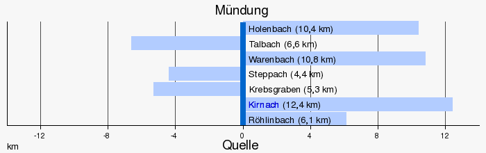
Table of the tributaries of the Brigach
For evidence, see the → detailed list below.
|
Stat. in km |
GKZ | Surname
|
location | Length in km |
EZG in km² |
Mouth | Mouth height in m above sea level NHN |
Source location | Source height in m above sea level NHN |
Remarks |
|---|---|---|---|---|---|---|---|---|---|---|
| 38,392 | 1112-112 | Zinkenbach | Left | 1.1 | 1.3 | St. Georgen - Auf der Matten | 860 | St. Georgen-Im Zinken | 888 | |
| 36,459 | 1112-12 | Sommeraubach | Left | 2.7 | 4.2 | St. Georgen-Kohlbühl | 820 | St. Georgen-Sommerau | 875 | |
| 34,692 | 1112-14 | Weidenbächle | Left | 2.4 | 2.6 | St. Georgen, train station | 800 | St. Georgen-Vohenlohe | 850 | |
| 33,760 | 1112-152 | Gickenlochbach | Left | 0.8 | 0.8 | St. Georgen, bridge z. former monastery | 790 | Forest Gickenloch | 818 | |
| 33.092 | 1112-16 | Harzlochbächlein | Left | 2.3 | 2.7 | St. Georgen origin | 785 | Reinschebrunnen north of St. Georgen-Rupertsberg | 830 | |
| 32,098 | 1112-18 | Mühlbach | Left | 2.5 | 2.9 | St. Georgen- Peterzell | 780 | St. Georgen-Lochbronn | 810 | |
| 31,475 | 1112-192 | Bärlochbächlein | Left | 2.5 | 2.3 | in front of St. Georgen-Schoren | 776 | Forest of red moss | 840 | |
| 30,249 | 1112-19 | Hagenmoosbach | Left | 1.0 | 1.1 | St. Georgen-Schoren | 770 | St. Georgen-Schoren | 800 | |
| 27,797 | 1112-2 | Röhlinbach | right | 6.1 | 10.2 | St. Georgen-Stockburger Mill | 760 | St. Georgen-Bösingerswinkel | 910 | |
| 27,617 | 1112-3 | Wannendobelbach | right | 1.4 | 1.1 | Unterkirnach -Wannendobel | 755 | Unterkirnach-Moosloch | 830 | |
| 26,885 | 1112-36 | Ellenwinkelbach | Left | 1.5 | 1.3 | Unterkirnach-Ellenwinkel | 750 | Mönchweiler , won Föhrenwald | 803 | |
| 26,860 | 1112-34 | Breitbrunnenbach | right | 1.3 | 1.3 | Unterkirnach-Gründle | 749 | Unterkirnach-Breitbrunnen | 835 | |
| 25,778 | 1112-38 | Gropperbach | right | 1.6 | 0.8 | Unterkirnach-Gropper | 742 | Forest Langmoos W Gropper | 847 | |
| 23,423 | 1112-4 | Kirnach | right | 12.4 | 33.1 | Villingen-Schwenningen , Kirnach-Villingen station | 725 | St. Georgen-Hagmichelshof | 950 | |
| 20,276 | 1112-52 | Crab pit | Left | 5.3 | 9.0 | Villingen , to Neuwiesenweg | 710 | Mönchweiler, won Luchten | 750 | |
| 19,895 | 1112-54 | Ziegelbach | Left | 3.1 | 3.4 | Villingen, after Wilhelm-Binder-Straße | 705 | Villingen, Sommertshauser Halde landfill | 745 | |
| 18,397 | 1112-7122 | Steppach | Left | 4.4 | 9.5 | Villingen, Schlachthausstrasse | 700 | Villingen-Nordstetten | 750 | opens into a side channel |
| 18,145 | 1112-6 | Warenbach | right | 10.8 | 19.1 | Villingen, in front of Roggenbachstrasse | 698 | Vöhrenbach summer forest | 930 | OL Wieselsbach |
| 14,296 | 1112-72 | Talbach | Left | 6.6 | 11.2 | to Villingen-Marbach | 690 | Villingen customs house | 717 | |
| 13,992 | 1112-792 | Old Holenbach | right | 1.2 | 0.3 | vs. Brigachtal -Kirchdorf | 689 | Villingen-Rietheim | 692 | |
| 13,880 | 1112-8 | Holenbach | right | 10.4 | 19.1 | vs. Brigachtal-Kirchdorf | 688 | Vöhringer summer forest | 915 | OL Wolfbach |
| 12,100 | 1112-92 | Bondelgraben | right | 2.9 | 3.8 | Brigachtal over-smoking | 697 | Weinhalde westl. Over-smoking | 735 | |
| 10,227 | 1112-9 | Ditch | right | 2.3 | 4.3 | Brigachtal-Beckhofen | 685 | Forest west of Beckhofen | 730 | |
| 1,420 | - | Donaubach | Left | 0.1 | 0.0 | Donaueschingen , castle garden | 680 | " Donauquelle " in the castle garden | 678 | gutted expiration d. nominal source of the Danube |
| 906 | 1112-992 | Canal from the Breg | right | 1.0 | 1.4 | Donaueschingen, outskirts in the O | 675 | Donaueschingen-Allmendshofen | 678 | also drains Brunnenbach (1.4 km) |
Notes on the table
- ↑ Water code number , in Germany the official river code number with a separator inserted after the prefix for better readability, which is uniform for the receiving waters shared by all stands.
Detailed list of the tributaries of the Brigach
Tributaries and side canals of the Brigach as well as the lakes in and on the river, listed from the source to the mouth. Water lengths, areas, catchment areas (partly added up) and heights according to the online map server of the State Institute for the Environment, Measurements and Nature Conservation Baden-Württemberg, → web links . Other sources are noted.
Brigach spring at about 925 m above sea level. NHN at the brain farm of Zinkens Obertal in the Brigach district of St. Georgen in the Black Forest . The Brigach initially flows east to northeast.
- Zinkenbach , from the left to about 860 m above sea level. NHN before the Zinken Untertal after the farm Auf der Matten, 1.1 km and about 1.3 km². Arises at about 888 m above sea level. NHN at the tine In the tine.
- Sommeraubach , from the left to over 820 m above sea level. NHN right after crossing under the Black Forest Railway at the Kohlbühl residential area, 2.7 km and 4.2 km². Arises at about 875 m above sea level. NHN in Zinken Sommerau.
-
 Flows through at about 820 m above sea level. NHN the monastery pond near St. Georgen itself, 2.6 ha.
 - Weidenbächle , from the left to less than 800 m above sea level. NHN at St. Georgen train station, 2.4 km and 2.6 km². Arises at about 850 m above sea level. NHN west of Zinkens Vohenlohe in the forest.
- Gickenlochbach , from the left to about 790 m above sea level. NHN at the Brigachbrücke near the former monastery, 0.8 km and approx. 0.8 km². Arises at about 818 m above sea level. NHN in the Gickenloch forest .
- → (exit of the canal to the sawmill farm), to the right immediately afterwards.
- Harzlochbächlein , from the left to below 785 m above sea level. NHN at around the original farm in the Brigach itself, 2.3 km and 2.7 km². Arises at about 830 m above sea level. NHN at the Reinschebrunnen in the Harzloch .
- ← (return of the Mühlkanal to the Sägerbauernhof), from the right to below 780 m above sea level. NHN across from the Peterzell district , 1.4 km.
- Mühlbach , from the left past Peterzell opposite the previous one, 2.5 km and 2.9 km². Arises at about 810 m above sea level. NHN near Zinken Lochbronn. From here the Brigach flows southeast to south after the apex of its initial northern arc.
- Bärlochbächlein , from the left to about 776 m above sea level. NHN a little before the sewage treatment plant at Schoren, 2.5 km and approx. 2.3 km². Arises at about 840 m above sea level. NHN in the Rotes Moos forest . Runs parallel on the other side of the railway line for a long time in the floodplain of the Brigach.
- Hagenmoosbach , from the left to about 770 m above sea level. NHN at Peterzeller Zinken Schoren, 1.0 km and approx. 1.1 km². Arises at almost 800 m above sea level. NHN on the northern outskirts.
- → (exit of the canal to Dobelhäusle), to the right to about 767 m above sea level. NHN .
- ← (return of the canal to Dobelhäusle), from the right to below 765 m above sea level. NHN at the Brigachbrücke to the St. Georgen district of Stockburg , 0.8 km.
- → (exit of the canal to Stockburger Mühle), to the right immediately after the previous one.
- ← (return of the canal to the Stockburger mill), from the right to over 760 m above sea level. NHN at this, approx. 0.5 km.
- Röhlinbach , from the right to below 760 m above sea level. NHN shortly after the Stockburger Mühle, 6.1 km and 10.2 km². Arises at about 910 m above sea level. NHN near St. Georgener Zinken Bösingerswinkel.
- Wannendobelbach , from the right to about 755 m above sea level. NHN at the first Unterkirnach residential area Wannendobel, 1.4 km and approx. 1.1 km². Arises at about 830 m above sea level. NHN at Zinken Moosloch from Unterkirnach .
- Ellenwinkelbach , from the left to less than 750 m above sea level. NHN at the Unterkirnacher Zinken Ellenwinkel, 1.5 km and approx. 1.3 km². Arises at about 803 m above sea level. NHN in the Fohrenwald of Mönchweiler .
- Breitbrunnenbach , from the right to about 749 m above sea level. NHN almost opposite the previous one at the Unterkinacher Hof Gründle, 1.3 km and approx. 1.3 km². Arises at about 835 m above sea level. NHN at the Unterschirnach residential area Breitbrunnen.
- Gropperbach , from the right to about 742 m above sea level. NHN at the Brigachbrücke to the Unterkirnacher Zinken Gropper, 1.6 km and approx. 0.8 km². Arises at about 847 m above sea level. NHN in the Langmoos forest .
- Kirnach , from the left to about 725 m above sea level. NHN opposite the Kirnach-Villingen train station, 12.4 km and 33.1 km². Arises at about 950 m above sea level. NHN on the eastern slope of the Kesselberg at the Hagmichelshof des Zinkens Kesselberg in the St. Georgen district of Oberkirnach . After this tributary, the Brigach runs continuously east.
-
Passed at about 722 m above sea level. NHN a group of three ponds on the right bank, a total of 0.3 ha.
- → (exit of the canal to Feldnermühle), to the left to a little over 720 m above sea level. NHN .
- ← (return of the canal to Feldnermühle), from the left to something below 720 m above sea level. NHN at this residential area in Villingen, 0.4 km.
- → (exit of the canal at the Villinger Kneipp bath), to the left immediately after the previous one.
-
In the spa park there is an elongated pond, 0.2 ha, between the canal and the river.
- ← (return of the canal at the Villinger Kneipp bath), from the left to a little over 710 m above sea level. NHN at the last jetty in the spa gardens, 0.9 km.
- → (exit of the Sägebach commercial canal), to the right to about 710 m above sea level. NHN immediately after the previous return flow in front of the bridge on Peterzeller Strasse. The canal is more than 500 meters away from the river and is covered at the beginning and at the end.
- Krebsgraben , from the left to around 710 m above sea level. NHN in Villingen after Neuwiesenweg, 5.3 km and 9.0 km². Arises at almost 750 m above sea level. NHN in front of the northeast edge of Mönchweiler in the Gewann Luchten .
- Ziegelbach , from the left a little over 705 m above sea level. NHN in Villingen at the entrance to the Vockenhäuser Straße (L 179), 3.1 km and 3.4 km². Arises at about 745 m above sea level. NHN on the southern edge of the landfill in the Sommertshauser Halde .
- ← (Return of the Sägebach commercial canal), from the right, under the Brigachbrücke of the Wehrstraße, 2.1 km. Here the Brigach makes a quarter turn and then flows further south.
- → (exit of the canal to the power plant in Mühlenstraße), to the left to a little over 700 m above sea level. NHN in Villingen am Wehr after the bridge on Donaueschinger Strasse.
- Steppach , from the left to about 700 m above sea level. NHN in Villingen on Schlachthausstrasse in the beginning power station canal, 4.4 km and 9.5 km². Arises at almost 750 m above sea level. NHN a little northeast of the Villingen hamlet of Nordstetten.
- Warenbach , from the right in Villingen about 200 meters after the weir with canal outlet, 10.8 km and 19.1 km². Arises as Wieselsbach at over 930 m above sea level. NHN between Neuhäuslewald and Sommerwald near the city limits to Vöhrenbach .
- ← (return of the canal to the power plant in Mühlenstraße), from the left to about 697 m above sea level. NHN in front of the bridge at the power station, 1.1 km.
- Talbach , from the left to almost 690 m above sea level. NHN between the southern district of Marbach and the district of Kirchdorf in the Brigachtal community , 6.6 km and 11.2 km². Arises at about 717 m above sea level. NHN at the Marbach Ost stop on the Villingen – Rottweil railway line near the Zollhaus hamlet.
- Alter Holenbach , from the right to about 689 m above sea level. NHN little after the previous one opposite the northern tip of Kirchdorf, 1.2 km and about 0.3 km². Meander run with little downward gradient that begins between Villingen-Rietheim and Kirchdorf in der Aue.
- Holenbach , from the left shortly after the previous one below the bridge of the road from Pfaffenweiler to Kirchdorf, 10.4 km and 19.1 km². Arises as Wolfbach at about 915 m above sea level. NHN far west of Villingen-Pfaffenweiler just beyond the city limits on the Vöhringer part of the summer forest. Lower course straightened.
- Bondelgraben , from the right opposite the Brigachtal-Klengen stop of the Black Forest Railway , 2.9 km and approx. 3.8 km². Arises at about 735 m above sea level. NHN west of Brigachtal-Überauchen under the vineyard .
- Valley ditch , from the right to almost 685 m above sea level. NHN through the Brigachtaler hamlet Beckhofen, 2.3 km and approx. 4.3 km². Arises at about 730 m above sea level. NHN west of the hamlet between Ochsenberg and Weißwald on the western border of the municipality.
-
to the left of the run is a lake in the Grüninger Ried nature reserve , 0.5 ha.
-
Backwater to the left of the course, downstream of the village of Grüningen von Donaueschingen , 0.1 ha.
-
Backwater to the left of the course at less than 680 m above sea level. NHN on a northeast loop of the Brigach just before Donaueschingen, 0.3 ha. After entering the settlement area of the city, the Brigach turns east.
- Donaubach , from the left to about 678 m above sea level. NHN at the level of the Princely Fürstenberg Castle Garden, under 0.1 km and 0.0 km². A cased karst spring in the castle garden, which is traded as a source of the Danube, is twisted along its entire length. See source of the Danube .
- (Canal inlet from the Breg), from the right to about 675 m above sea level. NHN on the eastern edge of the Donaueschingen settlement area, 1.0 km and approx. 1.3 km². At the northern end of the Allmendshofen district, turn left to about 678 m above sea level. NHN from the Breg and last of all takes on the 1.4 km slightly longer Brunnenbach from the left , which is below 680 m above sea level. NHN rises from a source on the northern edge of the Allmendshofen district.
Confluence from the left and west at below 675 m above sea level. NHN with the right Breg to the Danube , shortly before the Danube bridge of the B 27 and about one kilometer east of the outskirts of Donaueschingen.
Individual evidence
LUBW
Official online waterway map with a suitable section and the layers used here: Course and catchment area of the Brigach
General introduction without default settings and layers: State Institute for the Environment Baden-Württemberg (LUBW) ( notes )
- ↑ a b Length according to the waterway network layer ( AWGN ) .
- ↑ Catchment area after the layer aggregated areas 04 .
- ↑ Lake area according to the layer standing water of the LUBW's online map server.
- ↑ Catchment area according to the basic catchment area (AWGN) layer of the LUBW's online map server.
- ↑ a b Height according to the contour line image on the topographic map background layer .
- ↑ a b c d e f g h i j k l m catchment area measured on the background layer topographic map of the LUBW's online map server.
- ↑ Length measured on the background layer of the topographic map of the LUBW's online map server.