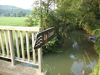
Louet (Adour)
| Louet | ||
|
The river at Vidouze |
||
| Data | ||
| Water code | FR : Q04-0400 | |
| location | France , Occitania and Nouvelle-Aquitaine regions | |
| River system | Adour | |
| Drain over | Adour → Atlantic Ocean | |
| source | in the municipality of Gardères 43 ° 16 ′ 18 ″ N , 0 ° 5 ′ 56 ″ W |
|
| Source height | approx. 391 m | |
| muzzle | in the municipality of Castelnau-Rivière-Basse in the Adour coordinates: 43 ° 35 ′ 45 ″ N , 0 ° 0 ′ 46 ″ W 43 ° 35 ′ 45 ″ N , 0 ° 0 ′ 46 ″ W |
|
| Mouth height | approx. 129 m | |
| Height difference | approx. 262 m | |
| Bottom slope | about 6 ‰ | |
| length | 44 km | |
| Right tributaries | Carbouère, Layza | |
The Louet is a river in France that runs through the Occitania and Nouvelle-Aquitaine regions. It rises under the name Ruisseau de Pissaca in the municipality of Gardères , generally drains in a northerly direction and flows into the Adour after 44 kilometers in the municipality of Castelnau-Rivière-Basse as a left tributary . On its way, the Louet crosses the Pyrénées-Atlantiques and Hautes-Pyrénées departments , and this is where the emphasis is placed, as the river touches not only the core area of Hautes-Pyrénées, but also some enclaves of this department in the neighboring Pyrénées-Atlantiques department.
Places on the river
(Order in flow direction)
Web links
Commons : Louet - collection of images, videos and audio files
Individual evidence
- ↑ Source geoportail.gouv.fr
- ↑ estuary geoportail.gouv.fr
- ↑ a b The information on the length of the river is based on the information about the Louet at SANDRE (French), accessed on July 23, 2013, rounded to full kilometers.
