
Gardères
| Gardères | ||
|---|---|---|
.svg)
|
|
|
| region | Occitania | |
| Department | Hautes-Pyrénées | |
| Arrondissement | Tarbes | |
| Canton | Ossun | |
| Community association | Agglomération Tarbes-Lourdes-Pyrénées | |
| Coordinates | 43 ° 17 ′ N , 0 ° 6 ′ W | |
| height | 337-413 m | |
| surface | 15.23 km 2 | |
| Residents | 443 (January 1, 2017) | |
| Population density | 29 inhabitants / km 2 | |
| Post Code | 65320 | |
| INSEE code | 65185 | |
| Website | www.garderes.fr | |
_1.jpg) Mayor's office ( Mairie ) of Gardères |
||

Gardères is a French commune with 443 inhabitants (as of January 1, 2017) in the Hautes-Pyrénées department in the Occitanie region (before 2016: Midi-Pyrénées ). The municipality belongs to the Arrondissement of Tarbes and the Canton of Ossun .
The inhabitants are called Gardérois and Gardéroises .
geography
Gardères is located about 16 kilometers west-northwest of Tarbes in an exclave of the department in the neighboring department Pyrénées-Atlantiques .
Gardères is surrounded by the six neighboring communities:
|
Eslourenties-Daban (Pyrénées-Atlantiques) |
Saubole (Pyrénées-Atlantiques) |
|
|
Lourenties (Pyrénées-Atlantiques) |
.svg)
|
Aast (Pyrénées-Atlantiques) |
| Luquet |
Ger (Pyrénées-Atlantiques) |
Population development
After records began, the population rose to a peak of around 785 by the middle of the 19th century. In the following period, the size of the community fell to around 340 with brief recovery phases until the 1980s, before a phase of growth began that continues today .
| year | 1962 | 1968 | 1975 | 1982 | 1990 | 1999 | 2006 | 2011 | 2017 |
|---|---|---|---|---|---|---|---|---|---|
| Residents | 389 | 363 | 343 | 342 | 396 | 381 | 408 | 424 | 443 |

Attractions
- Gardères Castle from the second half of the 18th century, inscribed as a Monument historique since 1997
- Parish Church of Saint-Julien
- The Gabas reservoir is used for irrigation for agriculture, holds up to 20 million m³ and has four communities as neighbors.

Gardères Castle

Parish Church of Saint-Julien
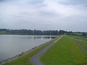
Gabas reservoir
_1.jpg)
_1.jpg)

Economy and Infrastructure

Agriculture is one of the most important economic factors in the municipality. The farms occupy an average of 12 hectares or 79% of the municipal area. The number of companies is falling sharply. In 1979 there were 62 farms, in 2015 there were only 31.
Gardères is located in the AOC zones of the Porc noir de Bigorre pig breed and the Jambon noir de Bigorre ham .

total = 54
education
The community has a primary school with 22 students in the 2019/20 school year.
traffic
Gardères can be reached via routes départementales 47, 69 (Pyrénées-Atlantiques: 42) and 70 (Pyrénées-Atlantiques: 311).
Web links
- Website of the Working Group of Noir de Bigorre (French)
- Gardères Castle website (French)
Individual evidence
- ^ Information commune de Gardères ( fr ) Marie-Pierre Manet. Retrieved November 15, 2019.
- ↑ Notice Communale Gardères ( fr ) EHESS . Retrieved November 15, 2019.
- ↑ Populations légales 2016 Commune de Gardères (65185) ( fr ) INSEE . Retrieved November 15, 2019.
- ^ Agriculture ( fr ) municipality of Gardères. Retrieved November 15, 2019.
- ↑ Institut national de l'origine et de la qualité: Rechercher un produit ( fr ) Institut national de l'origine et de la qualité . Retrieved November 15, 2019.
- ↑ Caractéristiques des établissements en 2015 Commune de Gardères (65185) ( fr ) INSEE . Retrieved November 15, 2019.
- ^ École élémentaire ( fr ) National Ministry of Education. Retrieved November 24, 2019.