
Laslades
| Laslades | ||
|---|---|---|
.svg)
|
|
|
| region | Occitania | |
| Department | Hautes-Pyrénées | |
| Arrondissement | Tarbes | |
| Canton | Les Coteaux | |
| Community association | Communes des Coteaux du Val d'Arros | |
| Coordinates | 43 ° 14 ′ N , 0 ° 10 ′ E | |
| height | 245-416 m | |
| surface | 5.26 km 2 | |
| Residents | 340 (January 1, 2017) | |
| Population density | 65 inhabitants / km 2 | |
| Post Code | 65350 | |
| INSEE code | 65265 | |
_1.jpg) View of the center of Laslades |
||

Laslades is a French commune with 340 inhabitants (as of January 1, 2017) in the Hautes-Pyrénées department in the Occitanie region (before 2016: Midi-Pyrénées ). The municipality belongs to the Arrondissement of Tarbes and the canton of Les Coteaux (until 2015: canton of Pouyastruc ).
The inhabitants are called Lasladais and Lasladaises .
geography
Laslades is located about eight kilometers east of Tarbes in its catchment area ( Aire urbaine ) in the historic province of Bigorre .
Laslades is surrounded by the seven neighboring communities:
| Souyeaux | Coussan | |
| Sarrouilles |
.svg)
|
Gonez |
| Barbazan debate | Lansac | Sinzos |
Population development
At the beginning of the records and in the middle of the 19th century, the population rose to a high of around 380. Subsequently, the number of residents fell with short recovery periods until the 1960s to a low of 185 before a phase with one at times strong growth began, which continues today.
| year | 1962 | 1968 | 1975 | 1982 | 1990 | 1999 | 2006 | 2011 | 2017 |
|---|---|---|---|---|---|---|---|---|---|
| Residents | 195 | 185 | 198 | 228 | 235 | 301 | 333 | 351 | 340 |

Attractions
- Parish Church of Sainte-Foi. It is the only church in the department dedicated to St. Fides de Agen .
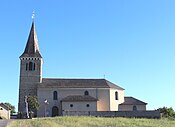
Parish Church of Sainte-Foi

View of the choir
_1.jpg)

Economy and Infrastructure

Laslades is located in the AOC zones of the Porc noir de Bigorre pig breed and the Jambon noir de Bigorre ham .

total = 26
_1.jpg)
education
The municipality has a public primary school with 20 students in the 2019/2020 school year.
traffic
Laslades can be reached via routes départementales 5, 21 and 135.
Long-distance trains of the national SNCF and trains of a line of the TER Occitanie , a regional train of the SNCF, run the route from Pau to Toulouse , which crosses the territory of the municipality on a relatively small section without a stop. The nearest train station is in Tarbes.
Web links
- Website of the Working Group of Noir de Bigorre (French)
- Laslades on the association's website (French)
- TER Occitanie website (French)
Individual evidence
- ↑ Hautes-Pyrénées ( fr ) habitants.fr. Retrieved November 24, 2019.
- ↑ Aire urbaine de Tarbes (072) ( fr ) INSEE . Retrieved November 24, 2019.
- ↑ Notice Communale Laslades ( fr ) EHESS . Retrieved November 24, 2019.
- ↑ Populations légales 2016 Commune de Laslades (65265) ( fr ) INSEE . Retrieved November 24, 2019.
- ↑ Laslades ( fr ) Communauté de communes des Coteaux du Val d'Arros. Retrieved November 24, 2019.
- ↑ Institut national de l'origine et de la qualité: Rechercher un produit ( fr ) Institut national de l'origine et de la qualité . Retrieved November 24, 2019.
- ↑ Caractéristiques des établissements en 2015 Commune de Laslades (65265) ( fr ) INSEE . Retrieved November 24, 2019.
- ^ École élémentaire ( fr ) National Ministry of Education. Retrieved November 24, 2019.