
Lubret-Saint-Luc
| Lubret-Saint-Luc | ||
|---|---|---|
.svg)
|
|
|
| region | Occitania | |
| Department | Hautes-Pyrénées | |
| Arrondissement | Tarbes | |
| Canton | Les Coteaux | |
| Community association | Communes du Pays de Trie et du Magnoac | |
| Coordinates | 43 ° 19 ′ N , 0 ° 18 ′ E | |
| height | 264-416 m | |
| surface | 5.61 km 2 | |
| Residents | 55 (January 1, 2017) | |
| Population density | 10 inhabitants / km 2 | |
| Post Code | 65220 | |
| INSEE code | 65288 | |
| Website | Lubret-Saint-Luc | |
_1.jpg) Mayor's office ( Mairie ) of Lubret-Saint-Luc |
||

Lubret-Saint-Luc is a French commune with 55 inhabitants (as of January 1, 2017) in the Hautes-Pyrénées department in the Occitanie region (before 2016: Midi-Pyrénées ). The municipality belongs to the Arrondissement of Tarbes and the canton of Les Coteaux (until 2015: canton of Trie-sur-Baïse ).
The inhabitants are called Lubrelucois and Lubrelucoises .
geography
Lubret-Saint-Luc is located about 21 kilometers northeast of Tarbes in the historic county of Bigorre on the northern edge of the department.
Lubret-Saint-Luc is surrounded by the six neighboring municipalities:
| Antin | Lapeyre | |
| Osmets |
.svg)
|
Lalanne-Trie |
| Luby-Betmont | Vidou |
Lubret-Saint-Luc is located in the catchment area of the Adour River .
The Bouès , a tributary of the Arros , essentially marks the border with the neighboring municipalities of Lapeyre, Lalanne-Trie and Vidou to the east. The Sarraillé is a tributary of the Bouès and has its source in the western part of the municipality.
Likewise, the Roumégas, a tributary of the Chella, irrigates the territory of the municipality together with its tributary, the Ruisseau de la Peyrole.
_3.jpg)
history
In 1322, which was Bastide Lubret founded under the shared fundamental rule of the local seigneur Bernard de Castelbajac and the Seneschal of Bigorre Jourdain de Lubret behalf of the French crown. Saint-Luc was founded in 1326 when the land was divided into two branches of the family following the death of Bernard de Castelbajac. The Ruisseau de Lagelle served as the border between the two fiefs of Lubret (south) and Saint-Luc (north). During the French Revolution a merger between Lubret, Saint-Luc, Luby and Betmont was envisaged, and in 1842 the merger of Lubret and Saint-Luc was carried out.
Toponymy
The Occitan name of the community is Lubret Sent-Luc. The origin of the name Lubret is unclear. It could be a diminutive of the neighboring municipality of Luby. The name of Saint-Luc is the patron saint of the place, the evangelist Luke .
The nickname of the residents of the municipality is Los tistalhèrs de Sent-Luc ( German the basket weavers of Saint-Luc ).
Toponyms and mentions of Lubret and Saint-Luc were:
- Lubret (1429, Bigorre County census list),
- Lubret (1750, 1792 and 1801, map by Cassini , Notice Communale or Bulletin des lois ),
- De Sancto Luca (1342, Tarbes Church Register),
- de Sancto Lucha (1369 and 1389, Larcher, Castelbajac),
- Sent Luc (1429, Bigorre County census list),
- St. Luc (1750, map by Cassini),
- Sinluc (1792, Notice Communale ),
- Saint-Luc (1801, Bulletin des lois ).
Population development
After the records began, the number of inhabitants rose to a high of around 425 in the middle of the 19th century, especially after the two communities merged. In the period that followed, the size of the community fell with short recovery phases to this day.
| year | 1962 | 1968 | 1975 | 1982 | 1990 | 1999 | 2006 | 2011 | 2017 |
|---|---|---|---|---|---|---|---|---|---|
| Residents | 102 | 89 | 89 | 98 | 103 | 91 | 75 | 72 | 55 |

Attractions
- Parish Church of Saint-Luc. It was built at the beginning of the 20th century and has building materials and decorations from earlier church buildings. The former Lubret chapel has now disappeared.
- Janette Castle and Mill were built by Odet de Castelbajac between 1460 and 1470.

Parish Church of Saint-Luc
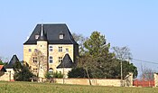
lock
_1.jpg)
_1.jpg)
Economy and Infrastructure

The municipality's economy is centered on agriculture. Lubret-Saint-Luc is located in the AOC zones of the Porc noir de Bigorre pig breed and the Jambon noir de Bigorre ham .

total = 17
traffic
Lubret-Saint-Luc can be reached via Routes départementales 11 and 611.
Web links
- Website of the Working Group of Noir de Bigorre (French)
- Lubret-Saint-Luc on the Pays de Trie et Magnoac Tourist Office website (French)
Individual evidence
- ↑ information commune de Lubret-Saint-Luc ( fr ) Marie-Pierre Manet. Retrieved November 29, 2019.
- ↑ Ma commune: Lubret-Saint-Luc ( fr ) Système d'Information sur l'Eau du Bassin Adour Garonne. Retrieved November 29, 2019.
- ↑ Lubret-Saint-Luc ( fr ) Tourist Office of the Pays de Trie et Magnoac. Retrieved November 29, 2019.
- ↑ Lubret-Saint-Luc ( fr ) Hautes-Pyrenees. Retrieved November 29, 2019.
- ^ David Rumsey Historical Map Collection France 1750 ( en ) David Rumsey Map Collection: Cartography Associates. Retrieved November 29, 2019.
- ↑ a b Notice Communale Lubret-Saint-Luc ( fr ) EHESS . Retrieved November 29, 2019.
- ^ Notice Communale Saint-Luc ( fr ) EHESS . Retrieved November 29, 2019.
- ↑ Populations légales 2016 Commune de Lubret-Saint-Luc (65288) ( fr ) INSEE . Retrieved November 29, 2019.
- ↑ Institut national de l'origine et de la qualité: Rechercher un produit ( fr ) Institut national de l'origine et de la qualité . Retrieved November 29, 2019.
- ↑ Caractéristiques des établissements en 2015 Commune de Lubret-Saint-Luc (65288) ( fr ) INSEE . Retrieved November 29, 2019.