
Thermes-Magnoac
|
Thermes-Magnoac Tèrmes |
||
|---|---|---|
.svg)
|
|
|
| region | Occitania | |
| Department | Hautes-Pyrénées | |
| Arrondissement | Tarbes | |
| Canton | Les Coteaux | |
| Community association | Pays de Trie et Magnoac | |
| Coordinates | 43 ° 18 ′ N , 0 ° 36 ′ E | |
| height | 266-416 m | |
| surface | 10.83 km 2 | |
| Residents | 212 (January 1, 2017) | |
| Population density | 20 inhabitants / km 2 | |
| Post Code | 65230 | |
| INSEE code | 65442 | |
_1.jpg) Town hall (Mairie) of Thermes-Magnoac |
||

Thermes-Magnoac ( Occitan : Tèrmes ) is a French commune with 212 inhabitants (as of January 1, 2017) in the Hautes-Pyrénées department in the Occitanie region ; it belongs to the Arrondissement of Tarbes .
geography
Thermes-Magnoac is located around 35 kilometers east-northeast of the city of Tarbes am Gimone in the east of the Hautes-Pyrénées department on the border with the Gers department. Thermes-Magnoac is surrounded by the neighboring communities of Mont-d'Astarac in the north and north-west, Boulogne-sur-Gesse in the north and east, Lalanne in the south and south-west, Betbèze in the south-west, Sariac-Magnoac in the west and Casterets in the north-west.
Population development
| year | 1962 | 1968 | 1975 | 1982 | 1990 | 1999 | 2006 | 2013 |
| Residents | 220 | 199 | 185 | 171 | 169 | 160 | 181 | 220 |
| Sources: Cassini and INSEE | ||||||||
Attractions
- Saint Barthélemy Church
- Saint Roch chapel
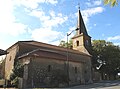
Saint Barthélemy Church

Saint Roch chapel
_1.jpg)
_1.jpg)
Web links
Commons : Thermes-Magnoac - collection of images, videos and audio files