
Guizerix
|
Guizerix Guiseric |
||
|---|---|---|
.svg)
|
|
|
| region | Occitania | |
| Department | Hautes-Pyrénées | |
| Arrondissement | Tarbes | |
| Canton | Les Coteaux | |
| Community association | Pays de Trie et Magnoac | |
| Coordinates | 43 ° 19 ′ N , 0 ° 27 ′ E | |
| height | 217-307 m | |
| surface | 7.2 km 2 | |
| Residents | 123 (January 1, 2017) | |
| Population density | 17 inhabitants / km 2 | |
| Post Code | 65230 | |
| INSEE code | 65213 | |
_1.jpg) City Hall (Mairie) of Guizerix |
||

Guizerix ( Occitan : Guiseric ) is a French commune with 123 inhabitants (as of January 1, 2017) in the Hautes-Pyrénées department in the Occitanie region ; it belongs to the Arrondissement of Tarbes . The inhabitants are called Guizerixois .
geography
Guizerix is located about 32 kilometers northeast of the city of Tarbes on the Petite Baïse River in the east of the Hautes-Pyrénées department. Guizerix is surrounded by the neighboring communities Cuélas in the north, Ponsan-Soubiran in the northeast, Larroque in the east, Puntous in the south and east, Sadournin in the west and Duffort in the northwest.
Population development
| year | 1962 | 1968 | 1975 | 1982 | 1990 | 1999 | 2006 | 2013 |
| Residents | 178 | 188 | 159 | 160 | 136 | 133 | 131 | 123 |
| Sources: Cassini and INSEE | ||||||||
Attractions
- Saint-Christophe Church
- Chapel of Sainte-Trinité
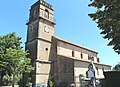
Saint-Christophe Church

Chapel of Sainte-Trinité
_2.jpg)
_1.jpg)
Web links
Commons : Guizerix - collection of images, videos and audio files