
Oroix
|
Oroix Auroish |
||
|---|---|---|
.svg)
|
|
|
| region | Occitania | |
| Department | Hautes-Pyrénées | |
| Arrondissement | Tarbes | |
| Canton | Vic-en-Bigorre | |
| Community association | Adour Madiran | |
| Coordinates | 43 ° 18 ′ N , 0 ° 2 ′ W | |
| height | 276-384 m | |
| surface | 8.890 km 2 | |
| Residents | 120 (January 1, 2017) | |
| Population density | 13 inhabitants / km 2 | |
| Post Code | 65320 | |
| INSEE code | 65341 | |
 Mairie Oroix |
||

Oroix ( Occitan : Auroish ) is a French commune with 120 inhabitants (as of January 1, 2017) in the Hautes-Pyrénées department in the Occitanie region ( Midi-Pyrénées until 2015 ). It belongs to the Arrondissement of Tarbes and to the Adour Madiran community association founded in 2016 . The inhabitants are called Ourouchois .
geography
_1.jpg)
Oroix is in the north of the Bigorre countryside , about 15 kilometers northwest of Tarbes and 35 kilometers east of Pau . The municipality extends along the three parallel rivers Lis , Luzerte and Géline , which flow in parallel in a south-north direction , the latter marking the eastern municipal boundary . The rivers drain to the Échez in the Adour catchment area . The terrain in the municipality is hilly and characterized by a mixture of fields, meadows and forests. In addition to the extensive village of Oroix, several individual farms belong to the municipality of Oroix . In the west and south, Oroix borders the Pyrénées-Atlantiques department . Oroix is surrounded by the neighboring communities of Tarasteix in the north, Lagarde and Oursbelille in the east, Pintac in the southeast, Ibos and Ger in the south and Ponson-Dessus in the west.
Place name
The village first appeared in 1342 as de Oroxio in a Latin document. The place name developed over Orox (1429), Ourouix and Ourouch (1734-1745) and Ourouix (1760) to Oroix, which has been used since the end of the 18th century until today .
Population development
| year | 1962 | 1968 | 1975 | 1982 | 1990 | 1999 | 2010 | 2016 |
|---|---|---|---|---|---|---|---|---|
| Residents | 126 | 122 | 122 | 119 | 117 | 122 | 120 | 121 |
| Sources: Cassini and INSEE | ||||||||
Attractions
- St. John the Baptist Church ( Église Saint-Jean-Baptiste )
- several wayside crosses
- Lavoir
- Landscape painting on a house wall
- Fallen memorial
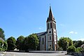
Saint-Jean-Baptiste church

Lavoir
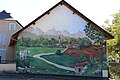
Mural

Fallen memorial

Community festival hall house

_2.jpg)

_1.jpg)
_1.jpg)
Economy and Infrastructure
There are 21 farms in the municipality of Oroix (grain cultivation, breeding of cattle, pigs, sheep and goats).
The city of Tarbes , 15 kilometers away, is a rail and road traffic junction with a connection to the A64 autoroute .
supporting documents
- ^ Dictionnaire toponymique des communes des Hautes-Pyrénées by Michel Grosclaude and Jean-François Le Nail
- ↑ Oroix on cassini-ehess.fr
- ↑ Oroix on insee, fr
- ↑ Farmers in Oroix on annuaire-mairie.fr (French)