
Escondeaux
|
Escondeaux Los Condaus |
||
|---|---|---|
.svg)
|
|
|
| region | Occitania | |
| Department | Hautes-Pyrénées | |
| Arrondissement | Tarbes | |
| Canton | Val d'Adour-Rustan-Madiranais | |
| Community association | Adour Madiran | |
| Coordinates | 43 ° 20 ' N , 0 ° 8' E | |
| height | 225–245 m | |
| surface | 3.79 km 2 | |
| Residents | 281 (January 1, 2017) | |
| Population density | 74 inhabitants / km 2 | |
| Post Code | 65140 | |
| INSEE code | 65161 | |
_1.jpg) Mairie Escondeaux |
||

Escondeaux ( Occitan : Los Condaus ) is a French commune with 281 inhabitants (as of January 1, 2017) in the Hautes-Pyrénées department in the Occitanie region (until 2015 Midi-Pyrénées ). It belongs to the Arrondissement of Tarbes and to the Adour Madiran community association founded in 2015 . The residents call themselves Escondolais .
geography
_1.jpg)
The municipality of Escondeaux is located in the north of the historic Bigorre landscape , about 13 kilometers north of Tarbes and 42 kilometers east of Pau . Although it belongs to the Hautes-Pyrénées (High Pyrenees) department, the municipality is located in an extremely flat lowland area, approx. 235 m above sea level. The 379 hectare municipal area has a north-south extension of approx. Five kilometers, but only 500 to 800 meters in an east-west direction. The community area is flat with a slight incline to the north (10 meters in altitude over 5 kilometers in length). The western boundary of the municipality marks the Aule , a tributary of the Estéous , the eastern boundary runs partially along the Canal d'Alaric , a flood protection canal for the Adour Valley. The river Oussette squeezes between the two rivers - also flowing in a south-north direction. With the exception of small remains of alluvial forest and fruit tree groves, the community area is forestless and characterized by large fields and pastures. The hamlet of Guillamots belongs to the community .
Escondeaux is surrounded by the neighboring communities Rabastens-de-Bigorre in the north, Lacassagne in the northeast, Lescurry in the east, Dours in the south, Tostat in the southwest and Bazillac in the northwest.
Place name
The village first appeared in 1429 under the Gascon and Latin names lo Candau, lo Condau de Rabastenx, lo deu Contau, lo deu Condau loquau and la billa d'Arebastenx . The place name developed via Condeaux and Condaux (1739), Escondaux , (1790) and Les Condaux on a Cassini map at the end of the 18th century to become Escondeaux, which is in use from 1845 and until today .
history
The municipality was created in 1845 when it was separated from the municipality of Rabastens-de-Bigorre .
Population development
| year | 1962 | 1968 | 1975 | 1982 | 1990 | 1999 | 2007 | 2016 |
|---|---|---|---|---|---|---|---|---|
| Residents | 144 | 143 | 146 | 153 | 213 | 212 | 243 | 280 |
| Sources: Cassini and INSEE | ||||||||
Attractions
- Saint-Jean-Baptiste church
- Hall crosses
- Fallen memorial
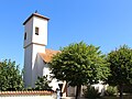
Saint-Jean-Baptiste church

Community ballroom

Fallen memorial
_1.jpg)
_1.jpg)
_1.jpg)
Economy and Infrastructure
The flat river landscape in the municipality of Escondeaux is cultivated by eleven farms (grain cultivation and cattle breeding).
The Route nationale 21 leads through Escondeaux from Tarbes to Auch , which has no curve for 20 kilometers. There are further road connections to all neighboring communities as well as to Ugnouas and Castéra-Lou . In Tarbes, 13 kilometers away, there is a connection to the A64 autoroute .
supporting documents
- ^ Dictionnaire toponymique des communes des Hautes-Pyrénées by Michel Grosclaude and Jean-François Le Nail
- ↑ toponym on cassini.ehess.fr
- ↑ Escondeaux on cassini.ehess.fr
- ↑ Escondeaux on insee, fr
- ↑ Farms on annuaire-mairie.fr (French)