Chis
|
Chis Shins |
||
|---|---|---|

|
|
|
| region | Occitania | |
| Department | Hautes-Pyrénées | |
| Arrondissement | Tarbes | |
| Canton | Bordères-sur-l'Échez | |
| Community association | Tarbes-Lourdes-Pyrénées | |
| Coordinates | 43 ° 18 ′ N , 0 ° 7 ′ E | |
| height | 256-276 m | |
| surface | 3.74 km 2 | |
| Residents | 315 (January 1, 2017) | |
| Population density | 84 inhabitants / km 2 | |
| Post Code | 65800 | |
| INSEE code | 65146 | |
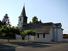
 Town Hall ( Mairie ) of Chis |
||
Chis ( Occitan : Shins ) is a French commune with 315 inhabitants (as of January 1, 2017) in the Hautes-Pyrénées department in the Occitania region (until 2015 Midi-Pyrénées ). It belongs to the Arrondissement of Tarbes and the Tarbes-Lourdes-Pyrénées municipal association founded in 2015 . The inhabitants are called Chissois .
geography
Chis is located in the Bigorre landscape , about eight kilometers north-northeast of Tarbes on the Alaric Canal . Chis is surrounded by the neighboring communities Aurensan in the north and west, Dours in the east and northeast and Orleix in the south.
The National Route 21 runs through the municipality .
Population development
| year | 1962 | 1968 | 1975 | 1982 | 1990 | 1999 | 2006 | 2011 | 2016 |
|---|---|---|---|---|---|---|---|---|---|
| Residents | 157 | 167 | 206 | 217 | 212 | 245 | 282 | 299 | 315 |
| Source: Annuaire-mairie and INSEE | |||||||||
Attractions
- Notre-Dame-de-l'Assomption church
supporting documents
Web links
Commons : Chis - collection of images, videos and audio files

