
Devèze
|
Devèze Devesa |
||
|---|---|---|
.svg)
|
|
|
| region | Occitania | |
| Department | Hautes-Pyrénées | |
| Arrondissement | Tarbes | |
| Canton | Les Coteaux | |
| Community association | Pays de Trie et du Magnoac | |
| Coordinates | 43 ° 16 ' N , 0 ° 33' E | |
| height | 284-422 m | |
| surface | 5.05 km 2 | |
| Residents | 59 (January 1, 2017) | |
| Population density | 12 inhabitants / km 2 | |
| Post Code | 65230 | |
| INSEE code | 65155 | |
_1.jpg) Mairie Devèze |
||

Devèze ( Occitan : Devesa ) is a French commune with 59 inhabitants (as of January 1, 2017) in the Hautes-Pyrénées department in the Occitanie region (until 2015 Midi-Pyrénées ). It belongs to the Arrondissement of Tarbes and the Pays de Trie et du Magnoac municipal association founded in 2016 . The inhabitants are called Devèziens .
geography
Devèze is located on the northeastern edge of the Lannemezan plateau , about 45 kilometers east of Tarbes and 45 kilometers south of Auch . The 5.05 km² community extends in the valley of the Cier , a tributary of the Gers, and over the surrounding hills. In the northeast of the municipality, the highest point is reached at 422 m above sea level. In the north, the Canal de l'Arrat meanders along the mountain flanks at 380 m above sea level. It is an almost 50-kilometer branch canal that branches off water from the Neste River and endows the Arrat River , which has too little water in summer. The river valley of the Cier forms a fertile arable and pasture landscape. In addition to the remains of alluvial forest on the banks of the Cier, there are large forest areas in the west and north-east of the municipality. Devèze includes the hamlets of Le Plan, Garrautou, Bouhue, Desprat, Lefèvre, Roucaud, Corraze, Le Dauphin, Arné, Les Bourdettes, Monlong, Terrade and Sabatier . Devèze is surrounded by the neighboring communities Betbèze in the north, Lalanne in the east, Pouy in the southeast, Villemur in the south, Monléon-Magnoac in the southwest and Aries-Espénan in the west.
Place name
The original Gascon name Devesa comes from the Latin defensa and translates as closed grazing . The village first appeared in a document in 1383 under the Latin name Devesia . The name developed over de Vezia (1405) and Devessia in the later 15th century to Deveze on a Cassini card of the late 18th century, before the spelling Devèze was established from 1801 , which has proven to be permanent to this day.
Population development
| year | 1962 | 1968 | 1975 | 1982 | 1990 | 1999 | 2007 | 2016 |
|---|---|---|---|---|---|---|---|---|
| Residents | 80 | 72 | 59 | 53 | 62 | 51 | 57 | 65 |
| Sources: Cassini and INSEE | ||||||||
Attractions
- Saint Martin Church
- Fallen memorial
- Hall crosses
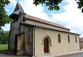
Saint Martin Church

Fallen memorial

one of the hall crosses

Community festival hall
_1.jpg)
_1.jpg)
_1.jpg)
_1.jpg)
Economy and Infrastructure
There are eleven farms in the municipality of Devèze (grain cultivation, cattle and horse breeding).
The D 632 road from Tarbes to Toulouse runs through the north of the municipality of Devèze . In the town of Lannemezan , 23 kilometers away, there is a connection to the A64 autoroute .
supporting documents
- ^ Dictionnaire toponymique des communes des Hautes-Pyrénées by Michel Grosclaude and Jean-François Le Nail
- ↑ Devèze on cassini.ehess.fr
- ↑ Devèze on insee, fr
- ↑ Farmers in Devèze on annuaire-mairie.fr (French)