Laloubère
|
Laloubère La Lobèra |
||
|---|---|---|

|
|
|
| region | Occitania | |
| Department | Hautes-Pyrénées | |
| Arrondissement | Tarbes | |
| Canton | Moyen-Adour | |
| Community association | Tarbes-Lourdes-Pyrénées | |
| Coordinates | 43 ° 12 ' N , 0 ° 4' E | |
| height | 320–346 m | |
| surface | 4.05 km 2 | |
| Residents | 1,883 (January 1, 2017) | |
| Population density | 465 inhabitants / km 2 | |
| Post Code | 65310 | |
| INSEE code | 65251 | |
| Website | Laloubère | |
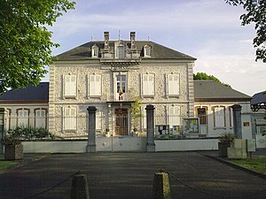
 Mairie Laloubère |
||
Laloubère is a French commune in the department of Hautes-Pyrénées in the region Occitania . It is located in the Arrondissement of Tarbes and the canton of Moyen-Adour .
Laloubère has 1883 inhabitants (as of January 1, 2017) on 4.05 square kilometers and is about 2.5 kilometers south of Tarbes in the Bigorre . The A64 autoroute leads through the municipality .
In the municipality of Laloubère is the Aérodrome de Tarbes-Laloubère , which is used as a civil airfield (two runways with 825 meters, built in 1936), but also by parachutists. On the southwestern edge is the racecourse (Hippodrome, built in 1808, distance: 1800 meters). The highway cuts the second large green area. Both are now used as golf areas ( Golf de l'Hippodrome and Golf des Tumulus ).
history
In the 10th and 11th centuries, the place was still led under Loupbatère . The Château de Laloubère is classified as a monument historique .

