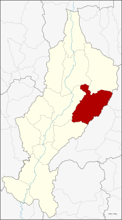
Amphoe Mae Mo
|
Mae Mo แม่เมาะ |
|
|---|---|
| Province: | Lampang |
| Surface: | 959.2 km² |
| Residents: | 39,771 (2013) |
| Population density : | 40.4 U / km² |
| ZIP : | 52220, 52000 |
| Geocode : | 5202 |
| map | |

|
|

Amphoe Mae Mo ( Thai อำเภอ แม่เมาะ , pronunciation: ʔāmpʰɤ̄ː mɛ̂ː mɔ́ʔ ) is a district ( Amphoe - administrative district) in the eastern part of Lampang Province . The Lampang Province is located in the northern region of Thailand .
geography
Neighboring counties (clockwise from the south): the Amphoe Mae Tha , Mueang Lampang , Chae Hom and Ngao of Lampang Province, and Song and Long of Phrae Province .
history
Mae Mo was established on April 15, 1976 as a "branch circle " ( King Amphoe ) , consisting of the three tambon Ban Dong, Chang Nuea and Na Sak, which were split off from Mueang Lampang County . On July 16, 1984, the subdistrict was given full amphoe status.
administration
Provincial Administration
Mae Mo County is divided into five tambon ("subdistricts" or "parishes"), which are further subdivided into 44 muban ("villages").
| No. | Surname | Thai | Muban | Pop. |
|---|---|---|---|---|
| 1. | Ban dong | บ้าน ดง | 8th | 4,861 |
| 2. | Well Sak | นา สัก | 9 | 6,196 |
| 3. | Chang Nuea | จาง เหนือ | 7th | 5,427 |
| 4th | Mae Mo | แม่เมาะ | 12 | 16,053 |
| 5. | Sop Pat | สบ ป้า ด | 8th | 7,234 |
Local administration
There is one municipality with "small town" status ( Thesaban Tambon ) in the district:
- Mae Mo (Thai: เทศบาล ตำบล แม่เมาะ ) consisting of the complete tambon Mae Mo.
There are also four " tambon administration organizations " ( องค์การ บริหาร ส่วน ตำบล - Tambon Administrative Organizations, TAO)
- Ban Dong (Thai: องค์การ บริหาร ส่วน ตำบล บ้าน ดง ) consisting of the complete Tambon Ban Dong.
- Na Sak (Thai: องค์การ บริหาร ส่วน ตำบล นา สัก ) consisting of the complete tambon Na Sak.
- Chang Nuea (Thai: องค์การ บริหาร ส่วน ตำบล จาง เหนือ ) consisting of the complete tambon Chang Nuea.
- Sop Pat (Thai: องค์การ บริหาร ส่วน ตำบล สบ ป้า ด ) consisting of the complete tambon Sop Pat.
Individual evidence
- ↑ ประกาศ กระทรวง มหาดไทย เรื่อง แบ่ง ท้องที่ อำเภอ เมือง ลำปาง จังหวัด ลำปาง ตั้ง เป็น กิ่ง อำเภอ แม่เมาะ . In: Royal Gazette . 93, No. 58 ง , April 13, 1976, p. 856.
- ↑ พระราชกฤษฎีกา ตั้ง อำเภอ ลาน กระบือ อำเภอ ดงหลวง อำเภอ ทรายมูล อำเภอ แม่เมาะ และ อำเภอ บัว เชด พ.ศ. ๒๕๒๗ . In: Royal Gazette . 101, No. 96 ก special, July 16, 1984, pp. 10-12.
- ↑ 2013 population statistics ( Thai ) Department of Provincial Administration. Retrieved October 27, 2014.
Web links
Coordinates: 18 ° 17 ' N , 99 ° 39' E
