Strait of Magellan
| Strait of Magellan | ||
|---|---|---|
| Satellite image of the southern tip of South America with the Strait of Magellan | ||
| Connects waters | Atlantic Ocean | |
| with water | Pacific Ocean | |
| Separates land mass | Patagonia , Isla Riesco , Isla Manuel Rodriguez , Isla Parker | |
| of land mass | Isla Grande de Tierra del Fuego , Isla Dawson , Isla Cap Aracena , Isla Clarence , Isla Santa Inés , Isla Desolación | |
| Data | ||
| Geographical location | 53 ° S , 71 ° W | |
|
|
||
| length | 570 km | |
| Smallest width | 3.5 km | |
| Southern Patagonia, the Strait of Magellan and Tierra del Fuego | ||
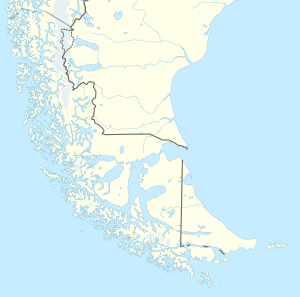
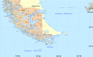
The Strait of Magellan ( Latin Fretum Magellanicum , Spanish Estrecho de Magallanes ) is a strait with numerous islands and branches between the South American mainland and southern islands, mainly the island of Tierra del Fuego . It connects the Atlantic and Pacific Oceans north of South America's southern tip. The Strait of Magellan is 330 nautical miles (= approx. 611 km) long from east to west , between 1080 m and 28 m deep and at its narrowest point (at Paso Tortuoso ) a little more than 2 km wide. The Strait of Magellan has been part of Chilean territory since the border treaty between Chile and Argentina in 1881 .
discovery
The Portuguese Fernão de Magalhães , who set out on an East Asia expedition in 1519 in the service of the Spanish crown as the commander of a ship fleet, found this passage in 1520. On October 21, the day of the 11,000 virgins , Magalhães sighted a cape near the 52nd parallel and consequently named it Cabo Virgenes ("Cape of the Virgins"). A severe storm that lasted more than a day drove two of his ships into a bay that eventually turned out to be a passage from the Atlantic to the Pacific Ocean. However, it took several weeks for Magalhães' fleet to find the western exit of the strait. It was not until November 27 or 28, 1520 that she sailed out into the open Pacific. Probably because it became clear to him on All Saints Day that he had finally found the long-sought passage to the west, Magalhães initially gave this body of water the Portuguese name Estreito de Todos os Santos (Strait of All Saints). The name Estrecho de Magallanes ("Magallan Strait") was still established in the 16th century .
In the course of the reconnaissance, a landing party was sent to the north coast, in that harsh and cold area that Magalhães had previously called Patagonia . But apart from a cemetery with around two hundred graves, the emissaries could not discover anything essential. In the south of the strait, however, the seafarers saw many fires blazing at night. They therefore called the country Tierra del Fuego , "Land of Fire".
fauna
The diverse animal world consists of albatrosses , seals , penguins and sea lions in the numerous branches of the sea passage.
meaning
The Strait of Magellan was of greatest importance before the construction of the Panama Canal , but it is still used by many ships today.
The connection between the Atlantic and the Pacific Ocean opened a western route to the economically important Spice Islands ( Moluccas ) in the 16th century . The rapid settlement of the west coast of South America was only made possible by the discovery of this waterway. Even after Willem Cornelisz Schouten discovered Cape Horn in 1616 and used the Drake Strait for the first time, the Strait of Magellan remained the preferred connection to the Pacific Ocean for the time being. On its shores, the seafarers could comfortably supply themselves with provisions and drinking water and were not exposed to the unpredictable forces of nature off Cape Horn.
With the advent of more modern sailing ships such as the windjammers and the length clock for safer navigation, the route around Cape Horn became increasingly easier to master, while steamships switched to the newly opened Panama Canal from 1914 onwards. For the otherwise Pacific Chile, the Strait of Magellan still means direct access to the Atlantic, which offers the Chilean economy a more direct route to European trading partners.
cities and communes
Web links
- Aviation map 1: 1,000,000, resolution 182 m / pixel (JPG, 8.7 MiB)
Individual evidence
- ↑ STRAIT OF MAGELLAN, CHILEAN CHANNELS AND FIORDS Regulations and information for PILOTING. ROUTES. Armada de Chile, accessed October 20, 2020 .
- ^ Mateo Martinic: Historia del Estrecho de Magallanes . Santiago de Chile 1977, p. 40 ff . ( gob.cl ).


