
Mariana Trench
 | |
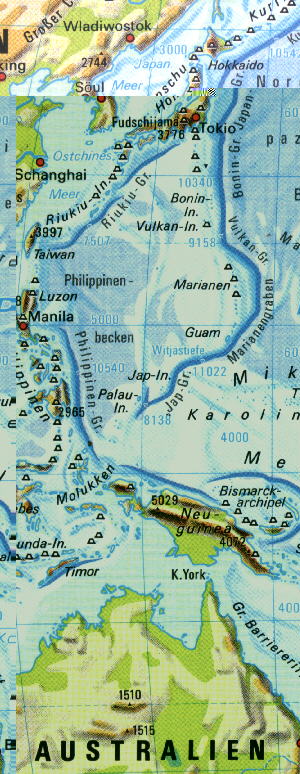
Location of the Mariana Trench in the Pacific Ocean
|
The Mariana Trench , also known as the Mariana Trench , is a deep sea channel (deep sea trench) in the western Pacific Ocean , in which the deepest part of the world ocean lies with a maximum depth of about 11,000 meters below sea level and which is about 2400 (2500) kilometers long. The water pressure at the lowest point is around 107 megapascals . Like the Mariana Islands, it was named after the Spanish Queen Maria Anna of Austria .

2) Mariana Basin
3) Mariana Islands
4) Mariana Forearc Basin
5) Mariana Trench
geography
Far north of the equator , the Mariana Trench runs directly east of the chain of islands belonging to the Micronesian Islands of the Mariana Islands . It is located on average around 2000 kilometers east of the Philippines , north and south of the Marian island of Guam . With its deepest known point of around 11,000 meters, the trench is considered the deepest seabed on earth. To the north, this semicircular deep-sea channel flows into the Boning Rift , which is followed further north by the Japangraben . In the north lies the Marshall Basin , in the south the Caroline Islands , in the southwest the Yapgraben and in the west - behind the Mariana Islands - the Philippines Basin . There the Mariana Trench lies between about 12 ° and 25 ° north latitude and 142 ° and 147 ° east longitude . The trench itself has a length of about 2,400 kilometers.
The Mariana Trench is part of a system that also includes the West Mariana Ridge, the Mariana Basin ( Backarc Basin ), the Mariana Arch and the Mariana Forearc Basin. The West Mariana Ridge is the western edge of a former island arch that split a few million years ago. Its two parts have since moved away from each other at a speed of a few centimeters per year, which is how today's Mariana Basin was created. The trigger was the tensile forces generated when the ocean floor plunged into the Earth's interior - the location of the Mariana Trench.
Ocean lows

In the Mariana Trench there are, among others, these sea lows :
- Witjastief 1 (11,034 meters according to a controversial measurement from 1957; therefore the deepest known point in the ocean )
- Challenger deep (10,928 meters)
- Trieste Deep (10,916 meters)
- Sirena Low (10,714 meters)
A study by the University of New Hampshire on December 7, 2011 revealed a depth of 10,994 ± 40 meters for the Challenger Deep. In a revised evaluation of the measurement data, the value was adjusted to 10,984 ± 25 meters.
New measurements by Victor Vescovo on April 28, 2019 showed a depth of 10,928 meters.
geology

The Mariana Trench forms the eastern part of the deeply incised seam between the Philippine plate in the west and the Pacific plate in the east. Here an older oceanic plate subducts under a younger oceanic plate. The subducted Pacific plate is over a hundred and fifty million years old in the area of the Mariana Trench and accordingly the oceanic lithosphere there has become very heavy and thick since its formation (as it cools, both the density and the thickness of the lithosphere increase).
Exploration of the Mariana Trench
_over_the_Marianas_Trench,_23_January_1960_(NH_96797).jpg)
On February 23, 1875, the crew of the HMS Challenger sounded out the deepest measured point in the world's oceans at 8,164 meters in the Mariana Trench.
In 1899 the US ship “Nero” determined a sea depth of 9,660 meters in the Mariana Trench using wire sounding.
In 1951 the crew of the English survey ship "Challenger II" determined a depth of 10,899 m with echo sounding (10,863 meters by wire sounding ); this place was given the name Challengertief.
In the International Geophysical Year 1957, the Vite Deep 1 (11,034 meters) was discovered by the Soviet research ship of the same name in the Mariana Trench.
On January 23, 1960, the Swiss Jacques Piccard and the American Don Walsh explored the channel with the Trieste submersible and descended to 10,916 m ( Trieste Deep).
More recently (1997/2001), for example, the Hawaii Mapping Research Group (HMRG) has devoted itself to mapping the Mariana Trench.
In 2012 James Cameron penetrated the deepest point of the sea with the submarine " Deepsea Challenger ". He collected data there for a good three hours and filmed the deep sea world (10,898 m). After Jacques Piccard and Don Walsh (10,916 m), Cameron is the third person to reach the lowest point in the world's oceans.
Between April 28, 2019 and May 5, 2019, four dives were completed in the Challenger Deep with the Limiting Factor submersible. On April 28, 2019, Victor Vescovo reached the new record depth of 10,928 m.
In 2018, researchers discovered microplastics in the benthal of the Mariana Trench.
Deepest previously known point in the ocean
At first the Galatheatief in the Philippinengraben with a depth of 10,540 meters was considered to be the deepest point in the oceans , since 1957 the Vitja Deep 1 in the Mariana Trench with 11,034 (echo sounding) meters holds this title; numerous sources give the depth there as 11,022 (wire soldering) meters. Meanwhile, some doubts about the measurement have arisen. That is why the Challenger Deep with 10,984 ± 25 m below sea level is also a candidate for the deepest point in the world's oceans.
fauna
The deep-sea fish Pseudoliparis swirei occurs in the Mariana Trench, and according to current knowledge is the deepest fish species. Live specimens were filmed at depths of 6,198 to 8,098 meters.
Others
On January 18, 2009, the Mariana Trench was declared a National Monument of the United States by President George W. Bush . A survey carried out in 2011 by geoscientists from the University of New Hampshire in the USA with an underwater robot was intended to examine whether the USA was entitled to larger marine regions around the US American islands of Guam and the northern Mariana Islands. The results were published at the end of 2011. A sea zone of 200 nautical miles belongs to the respective national territory according to international recognition. The university's researchers have identified four underwater mountains on their maps that could be considered an extension of the American territory from Guam and the northern Mariana Islands.
See also
Web links
- Albert E. Theberge: Thirty Years of Discovering the Mariana Trench In: Hydro International , Volume 12, No. 8, 2008, ISSN 1385-4569 , pp. 38-39 ( online as PDF ; 96.1 KB).
- Natalya Gallo, James Cameron , Kevin Hardy, Patricia Fryer, Douglas Bartlett, Lisa Levin: Submersible- and lander-observed community patterns in the Mariana and New Britain trenches: Influence of productivity and depth on epibenthic and scavenging communities In: Deep Sea Research Part 1ː Oceanographic Research Paper , Volume 99, May 2015, ISSN 0967-0637 , pp. 119-133, DOI:: 10.1016 / j.dsr.2014.12.012 , ( online as PDF ; 8.45 MB).
- Map with the location of the Mariana Trench
- The Challenger Deep
- Mariana Trench in Google Maps
Individual evidence
- ↑ a b c ( page no longer available , search in web archives: insights into the deepest place on earth - research team measures the Mariana Trench again ) , NZZ , December 9, 2011
- ↑ http://www.bbc.co.uk/news/science-environment-15845550
- ↑ Brockhaus, 20th ed., Vol. 22, p. 84 (1999)
- ↑ James V. Gardner, Andrew A. Armstrong, Brian R. Calder, Jonathan Beaudoin: So, How Deep Is the Mariana Trench? Marine Geodesy, 37: 1–13, 2014 ( PDF, 573 KB )
- ↑ In the Mariana Trench: American dives 10,928 meters deep - and finds a plastic bag . In: Spiegel Online . May 14, 2019 ( spiegel.de [accessed June 28, 2019]).
- ^ Encyclopædia Britannica
- ↑ BBC: Sea floor survey reveals deep hole
- ↑ James Cameron dives to the deepest point of the sea
- ↑ Press release of the Five Deeps Expedition on the dives in the Mariana Trench (PDF; 209 KB; English), accessed on May 14, 2019
- ↑ Deepest ever dive at bottom of Mariana Trench , accessed on May 13, 2019
- ↑ X. Peng, M. Chen, S. Chen, S. Dasgupta, H. Xu, K. Ta, M. Du, J. Li, Z. Guo, S. Bai: Microplastics contaminate the deepest part of the world's ocean . In: Geochemical Perspectives Letters . 2018, ISSN 2410-3403 , pp. 1-5. doi : 10.7185 / geochemlet . 1829 .
- ↑ Gerringer, ME, Linley, TD, Jamieson, AJ, Goetze, E. & Drazen, JC (2017): Pseudoliparis swirei sp. nov .: A newly-discovered hadal snailfish (Scorpaeniformes: Liparidae) from the Mariana Trench. Zootaxa , 4358 (1): 161-177. DOI:: 10.11646 / zootaxa.4358.1.7
- ↑ Presidential Proclamation 8335 - Establishment of the Marianas Trench Marine National Monument (with map; PDF; 2.1 MB)
Coordinates: 11 ° 21 ′ 0 ″ N , 142 ° 12 ′ 0 ″ E