
Marocche di Dro

Marocche di Dro is a landslide area in the southwest of the Italian province of Trento . It is partly a nature reserve that belongs to the NATURA 2000 network.
Surname
The name Marocche is derived from the word maròch , which means a stone or boulder in the Trentino dialect . In Trentino it is also applied to other landslide and landslide areas, such as the Marocca di Torbole or Marocca di Passo San Giovanni , whose slopes are characterized by large stone or boulders. The name Marocche has been adopted as a geological term over time and denotes masses of debris that can be traced back to landslides and that were subsequently transported by glaciers as an erratic block . A definition that is misleading in the case of the Marocche di Dro.
geography
Demarcation
The area is located about 12 km northeast of Lake Garda in the lower Sarca Valley . The latter, like Lake Garda , is influenced by the Judicaria Line, a tectonic fault line , and runs parallel to this line from northeast to southwest.
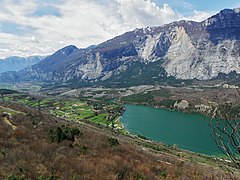
The debris and block heaps of the Marocche di Droht extend in the valley floor from northeast to southwest from Pietramurata ( 248 m slm ) to north of Dro ( 124 m slm ) and are crossed by the Sarca river. They are delimited to the north and south by alluvial plains . They are embedded on the west side by the ridge of Monte Casale ( 1634 m ) and Monte Brento ( 1544 m ) and in the east by Dos Salin ( 802 m ), which separates the lower Sarca valley from the Cavedine valley with the Monte Bondone - Monte Stivo ridge. The Cavedinesee lies in the eastern part of the landslide area below the Dos Salin . With Lake Solo , also known as Laghisol , and Lake Bagatolli, there are two other smaller bodies of water in the Marocche di Dro area.
structure
The Marocche of Dro is one of several Bergsturz- and landslide areas , both on the lower reaches of the Sarca orographic left their mark left and on the right side of the valley. Strictly speaking, it describes the deposit area of several landslides and landslides that occurred at different times. The geologist Giovanni Battista Trener , who was the first to study the Marocche di Dro in detail, differentiated a total of twelve different deposition areas in the Sarca Valley in 1924 based on lithostratigraphic and geomorphological criteria as well as the texture of the rock, five of them in the area of the Marocche di Dro. The three largest are from north to south Masi di Lasino, Marocche and Kas.

The Valle dei Laghi facing south, with Lake Cavedine and the Marocche

The valley facing north, on the left the ridge of Monte Brento-Casale
Cavedinesee with the overgrown Marocche rockslide (right) the vegetation-free Kas rockslide (left)

The Kas rockslide looking towards Dro

The hilly landscape in the Marocche


_-_panoramio.jpg)


Masi di Lasino
Landslide on the orographic left side of the valley of the Sarca valley northwest of the Cavedinesees and thus also the only one that has detached itself from the left side of the valley in the Marocche di Dro landslide area. The breaking point is on the ridge west of Lasino , which separates the Sarca valley from the Cavedine valley, at an altitude between 625 m and 537 m , so that the landslide covered a maximum difference in altitude of about 410 m. The rubble and block dump is 1.7 km long and up to 2.6 km wide. It rises from the surrounding area on an area of almost 1.3 km² and is up to 60 m thick. Parts of the dump have been filled in by the Sarca alluvial plain that was created later, with some characteristic Toma hills protruding near Pergolese , on which some buildings stand. In the south and west, the deposits are partially covered by the Marocche heap.
Marocche
Also known as Marocca principale . The deposit area of the landslide extends over a length of 5 km from Pietramurata in the north to the Toma hill Sant'Abbondio near Dro. The latter is in part also viewed as an independent landslide event. The width of the dump varies between 1.5 and 2 km and even reaches 3 km in the south at Sant'Abbondio. It covers an area of 10 km² and has a volume of 1 km 3 . It is thus by far the largest dump in the Marocche di Dro landslide area and rises to a height of around 320 m , while it is around 130 m thick. The break off point on the orographically right side of the valley extends from Monte Casale to Monte Granzoline and probably beyond to Monte Brento. The rubble of the landslide covered an estimated 5.8 km, crossed the Sarca Valley in its entire width and surged up on the Doss Salin up to a height of 570 m . The deposition area is relatively flat and overgrown with coppice , larger boulders can only be found in the northeastern area and west of Lake Cavedine. In the south it is overlaid by the rock dump of the Kas landslide.
Cheese
The slope of the Kas landslide is about 3 km long and 0.5 to 1.5 km wide. On the opposite side of the valley, it swung about 100 m in height and covered an area of about 3.5 km², thereby superimposing the southern deposition area of the Marocche landslide. The heap has an estimated thickness of 80 m, so that a volume of 300 million m 3 can be assumed. The breaking point is clearly recognizable on Monte Brento and on the adjoining Monte La Costa to the south on the orographically right side of the valley. It lies well below the summit ridge and the more weathered area in between belongs to the point where the Marocche principale landslide broke off. Characteristic of the morphology of the deposit area of the Kas landslide are the 5 to 10 m high rubble walls extending in the longitudinal direction from the wall in a circle. The eastern end of the heap is characterized by ramparts several meters high and running across the deposit area. The dump is a block dump with little vegetation and as such is easy to spot in the area. The stone blocks, some of the size of a house, reach edge lengths of around 20 m and occur particularly in the area of Lake Laghisol .
geology
The Marocche di Dro deposit area is made up of various formations of sedimentary rocks , including in particular gray limestone that formed on the Tridentine threshold in the Lower Jurassic . Furthermore oolites and Ammonitico Rosso found from Monte Casale.
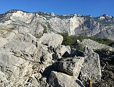
Scree slope with demolition point Monte Brento (right) and Monte Costa (left)

Nature trail through the biotope

The heavily overgrown lake Laghisol
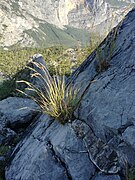
Exemplary colonization of the scree slopes

The Fies hydropower plant in World War I with the not yet afforested Marocche behind it


.jpg)
Paleogeography
The history of the origins of the Marocche di Dro was discussed among scientists from the 19th century. A smaller part of the scientists viewed the Marocche as a glacial result, which was nothing more than the moraine of the glacier of the last glacial period that ran through the Sarca Valley. This assumption was countered by the hypothesis that the Marocche was due to a catastrophic event, namely a landslide. A third theoretical approach led the Marocche back a landslide, but the dump was deformed by a glacier.
For a long time, it was assumed that the landslide was triggered by the decrease in back pressure due to the melting of the glacier. The different facies and the tectonic fault line would have contributed to the instability. In the 1980s, seismic waves resulting from strong earthquakes were also considered as a trigger.
In the 1990s, using the radiocarbon method, it was established that the first of the landslides occurred between 2950 and 2600 BC at the earliest. And the last, Kas, between 400 and 200 BC at the earliest. Occurred.
Using the surface exposure dating, it was possible in the 2010s to determine the age of the two landslides Marocche and Kas more precisely using the chlorine method. The data obtained for the Marocche landslide resulted in an age of 5300 ± 860 years and for Kas an age of 1080 ± 160 years.
Based on these results, it could be ruled out that the Marocche landslide is directly related to the melting of the Adige Glacier, for example Lake Garda, just a few kilometers to the south, was already ice-free around 17,000 years ago. The Marocche landslide occurs at a time when other landslides have occurred in the Alps and can be attributed to climate fluctuations, in this case colder and more precipitous weather, which contributed to the instability of the mountain flanks. However, it cannot be ruled out that the landslide was triggered by an earthquake.
An earthquake, on the other hand, was very likely the trigger for the much younger Kas landslide. During the period of the landslide determined using the chlorine method, two stronger earthquakes, both with a strength of IX MCS , are documented. On the one hand the earthquake in Verona of 1117 and on the other hand the earthquake of 1046 in the Adige Valley about eleven kilometers away . Due to its proximity, the earthquake of 1046 could well have triggered the Kas landslide.
This also refuted that the Kas rockslide took place in the Roman era. A hypothesis that was put forward after excavations during the construction of the Dro hydroelectric power station in the 1920s, the remains of a roof tile that could not be determined any more precisely, which was later lost, and which Trener associated with the historically unprovable Roman settlement of Kas .
However, it can be proven that the course of the Sarca changed several times as a result of the landslides, even if the former location of the river between the landslides Marocche and Kas is controversial. In any case, north of the landslide area, the Sarca built up into a lake, the remnant of which is the Lago di Cavedine in the south and which originally extended over the alluvial plain near Sarche to Lake Toblin and Lake Massenza. Due to the lack of settlements in the alluvial plain, it can be assumed that this area was swampy and uninhabitable for a long time. The settlements near Pergolese, which were partly built on the Toma hills of the Masi di Lasino landslide and protrude from the alluvial plain, testify to this.
Flora and fauna
The Marocche of Dro have been part of a nature reserve since 1989, which has been part of the Natura 2000 network since 1995. Due to the predominantly desert-like scree slopes, it has special requirements. The plants managed to colonize the deposit area in an exemplary manner. In the first half of the 20th century, the edge areas of the Marocche in particular were reforested with black pines , maritime pines , Greek firs and Mediterranean cypresses . Especially in the area of the Fies and Dro hydroelectric power stations, the area of the hydraulic structures was embellished with black pines. A species that is not otherwise native to Trentino and has proven to be very susceptible to pests.
literature
- Agenzia per la protezione dell'ambiente e per i servizi tecnici - APAT (ed.): Note illustrative della Carta geologica d'Italia - 1: 50,000: Foglio 080 Riva del Garda . S.EL.CA., Rome 2005.
- Michele Bassetti: Studio geomorfologico sulle “Marocche” di Dro (Trentino occidentale) . In: Studi Trentini di Scienze Naturali - Acta Geologica . Volume 72 (1995), Trient 1997, ISSN 0392-0534 pp. 5-30.
- Michele Bassetti, Nicola Cappellozza, et al .: Modificazioni geomorfoliche e aspetti geoarcheologici del territorio del Sommolago. Elementi per una ricostruzione del paesaggio . In: Gian Pietro Brogiolo (ed.): APSAT 3. Paesaggi storici del Sommolago . SAP Società Archeologica srl., Mantua 2013, ISBN 978-88-87115-78-9 .
- Susan Ivy-Ochs, Silvana Martin, Paolo Campedel et al .: Geomorphology and age of the Marocche di Dro rock avalanches (Trentino, Italy) . In: Quaternary Science Reviews N. 169 August 2017, ISSN 0277-3791 pp. 188-205.
- Paolo Minghetti: Piccola guida botanica al biotopo Marocche . Provincia Autonoma di Trento, Trento 2001.
- M. Scheuber: On the geology of the landslide masses in the lower Sarca valley. Arb. Inst. Geol. Paleont. Univ., Stuttgart 1988, OCLC 797881857 .
Web links
Individual evidence
- ↑ Piccolo vocabolario Trentino Italiano. In: arcopoesia.wordpress.com. Retrieved July 14, 2020 (Italian).
- ↑ Agenzia per la protezione dell'ambiente e per i servizi tecnici - APAT (ed.): Note illustrative della Carta geologica d'Italia - 1: 50,000: Foglio 080 Riva del Garda pp. 79-80.
- ↑ Susan Ivy-Ochs, Silvana Martin, Paolo Campedel et al .: Geomorphology and age of the Marocche di Dro rock avalanches (Trentino, Italy) p. 189.
- ↑ Michele Bassetti, Nicola Cappellozza, et al .: Modificazioni geomorfoliche e aspetti geoarcheologici del territorio del Sommolago. Elementi per una ricostruzione del paesaggio p. 20.
- ↑ Michele Bassetti, Nicola Cappellozza, et al .: Modificazioni geomorfoliche e aspetti geoarcheologici del territorio del Sommolago. Elementi per una ricostruzione del paesaggio p. 14.
- ↑ Michele Bassetti: Studio geomorfologico sulle “Marocche” di Dro (Trentino occidentale) pp. 16-17.
- ↑ Michele Bassetti: Studio geomorfologico sulle “Marocche” di Dro (Trentino occidentale) pp. 17-18, 26.
- ↑ Susan Ivy-Ochs, Silvana Martin, Paolo Campedel et al .: Geomorphology and age of the Marocche di Dro rock avalanches (Trentino, Italy) p. 193.
- ↑ Susan Ivy-Ochs, Silvana Martin, Paolo Campedel et al .: Geomorphology and age of the Marocche di Dro rock avalanches (Trentino, Italy) pp. 195-199.
- ↑ Susan Ivy-Ochs, Silvana Martin, Paolo Campedel et al .: Geomorphology and age of the Marocche di Dro rock avalanches (Trentino, Italy) p. 189.
- ↑ Michele Bassetti: Studio geomorfologico sulle “Marocche” di Dro (Trentino occidentale) p. 16
- ↑ Susan Ivy-Ochs, Silvana Martin, Paolo Campedel et al .: Geomorphology and age of the Marocche di Dro rock avalanches (Trentino, Italy) p. 199.
- ^ M. Bassetti: Studio geomorfologico sulle “Marocche” di Dro (Trentino occidentale). In: Studi Trent. Sci. Nat., Acta Geol. Volume 72, 1995, pp. 5-30. Quoted in: Michele Bassetti, Andrea Borsato: Evoluzione geomorfologia della Bassa Valle dell Adige dall ultimo massimo glaciale: sintesi delle conoscenze e riferimenti ad aree limitrofe. (PDF; 4.9 MB). In: Studi Trent. Sci. Nat., Acta Geol. Volume 82, 2005, p. 36 f.
- ^ Susan Ivy-Ochs, Silvana Martin, Paolo Campedel et al .: Geomorphology and age of the Marocche di Dro rock avalanches (Trentino, Italy) pp. 194, 198.
- ↑ a b c Susan Ivy-Ochs, Silvana Martin, Paolo Campedel et al .: Geomorphology and age of the Marocche di Dro rock avalanches (Trentino, Italy) p. 202.
- ↑ Susan Ivy-Ochs, Silvana Martin, Paolo Campedel et al .: Geomorphology and age of the Marocche di Dro rock avalanches (Trentino, Italy) p. 199.
- ↑ Paolo Minghetti: Piccola guida botanica al biotopo Marocche p. 99.
Coordinates: 45 ° 59 ′ 13.7 ″ N , 10 ° 56 ′ 13.8 ″ E