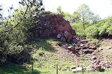
Martenberg cliff
The Martenberg Cliff , also known as Adorfer Klippe , Rote Klippe and popularly known as the Rosenschlösschen , is a geological natural monument on the 429 m high Martenberg in the Diemelsee Nature Park in North Hesse .
Geographical location
It is located in a former iron ore - open pit approximately 1.7 km north-northeast of the center of town in the district of Adorf , in the municipality Diemelsee in Hesse Waldeck-Frankenberg . About 100 m east of the cliff, the K 88 district road runs from Adorf to Giershagen , a southern district of the city of Marsberg in North Rhine-Westphalia , in a south-north direction . (The state border runs about 2 km further north.) At the junction of the road “Auf dem Martenberg” from the K 88 there is a parking lot, where information boards provide information about the geology , scenic features and mining history of the area, and from where you can reach the cliff in a few Minutes on foot. About 1 km to the west, on the main road is L 3076 (Bredelaer street), the visitor mine " Grube Christiane " with a museum for mining, geology and minerals in the region.
The cliff
The geological structure of the approximately eight-meter-high cliff includes a threshold profile , which is greatly reduced in thickness, made of mainly fossil-rich limestones from the Middle to Upper Devonian ( Givet and Adorf levels), which are impregnated with iron ore and are therefore of an intense red color, with gray-green slate the Nehden level above. The limestones of Givet- and Adorf levels include a rich, well over 300 million year old fossilized haematite - fauna of cephalopods ( cuttlefish ), brachiopods ( brachiopods ), trilobites (Dreilapp- arthropods ), crinoids ( sea lilies ), conodonts and solitary corals . The slates of the Nehden stage contain a rich shellfish fauna.
The interest of paleontologists and biostratigraphers in the Martenberg was aroused very early, and at the beginning of the 20th century the term "Adorf stage" was coined. The Martenberg cliff then became the type locality and guide profile of the Adorf level of the Devonian.
See also
Individual evidence
- ↑ a b c Hessian State Office for Environment and Geology: The Martenberg Cliff or our "Rosenschlösschen" ( Memento from March 4, 2016 in the Internet Archive )
- ↑ Geopark Grenzwelten: The Adorfer Cliff ( Memento from April 22, 2017 in the Internet Archive )
Web links
- Martenberg at mineralienatlas.de
Coordinates: 51 ° 22 ′ 30.2 ″ N , 8 ° 48 ′ 46.4 ″ E


