
Marynopil (Rosiwka)
| Marynopil | |||
| Маринопіль | |||

|
|
||
| Basic data | |||
|---|---|---|---|
| Oblast : | Zaporizhia Oblast | ||
| Rajon : | Rosivka district | ||
| Height : | 184 m | ||
| Area : | 1.6 km² | ||
| Residents : | 424 (2001) | ||
| Population density : | 265 inhabitants per km² | ||
| Postcodes : | 70314 | ||
| Area code : | +380 6162 | ||
| Geographic location : | 47 ° 30 ' N , 36 ° 51' E | ||
| KOATUU : | 2324984005 | ||
| Administrative structure : | 1 village | ||
| Address: | вул. Центральна буд. 10 70313 с. Новозлатопіль |
||
| Website : | Official website of the district council | ||
| Statistical information | |||
|
|||


Marynopil ( Ukrainian Маринопіль ; Russian Маринополь Marinopol ) is a village in the east of the Ukrainian Oblast of Zaporizhia with about 420 inhabitants (2001).
geography
The village with an area of 1.6 km² belongs administratively to the district council of Novoslatopil ( Новозлатопіль , ⊙ ; until 2016 Пролетарське Proletarskoye ) in the west of Rosivka district .
The village is situated at an altitude of 184 m km south from 3 community center Nowoslatopil, 23 km northwest of the Rajonzentrum Rosiwka and 160 km south-east of Oblastzentrum Zaporizhia .
history
The colony no. 26 in 1842 under the name Marienfeld in the district of Mariopol yekaterinoslav governorate of 23 from Rheinhessen immigrant German families Lutheran denomination as planners colony founded. The colony was named Marienfeld in honor of the wife of the then Russian Emperor Alexander II. Marie von Hessen-Darmstadt . Another 8 families came in 1845 from the Lutheran parishes of Grunau (Colony No. 6 - Alexandronewsk - today in the northeastern part of Rosiwka) and Ludwigstal (Colony No. 19 - today Zorya / Зоря ). Among other things, the founders built a house of prayer and a school. They had an area of 1,500 acres for cultivation. After the Bolsheviks won the Russian Civil War and founded the Ukrainian SSR , the village was given its current name in 1922. Between 1925 and 1939 the village was located in the Luxemburg-German Nationalrajon ( Люксембургский немецкий национальный район ) within the Okrug Mariupol ( Мариупольский округlast ), which in turn was in the Oblast from 1932-1939 . With the beginning of the German-Soviet War , the German population was banished to Central Asia and Siberia and the German history of the colony came to an end.
Demographic development
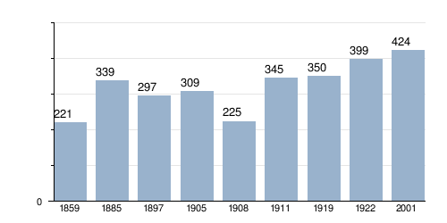
Sources : until 1922, 2001
Web links
- Local history of Marynopil in the history of towns and villages of the Ukrainian SSR (Ukrainian)
- Website of the Novoslatopil Municipal Council on rada.info (Ukrainian)
Individual evidence
- ↑ a b c d local website on the official website of the Verkhovna Rada ; accessed on May 11, 2019 (Ukrainian)
- ↑ Верховна Рада України; Постанова від 19.05.2016 № 1377-VIII Про перейменування окремих населених пунктів та районів
- ^ Germans in Russia The colonies near Mariupol on the Sea of Azov; accessed on May 11, 2019 (Russian)
- ↑ a b c The German Russia Settlements and Settlement Areas Lexicon; Page 289 МАРИЕНФЕЛЬД / MARIENFELD; accessed on May 11, 2019 (Russian)