
Meycauayan
| Meycauayan | |||
| Location of Meycauayan in the province of Bulacan | |||
|---|---|---|---|

|
|||
| Basic data | |||
| Region : | Central Luzon | ||
| Province : | Bulacan | ||
| Barangays : | 26th | ||
| District: | 4. Bulacan District | ||
| PSGC : | 031412000 | ||
| Income class : | 3rd income bracket | ||
| Households : |
May 1, 2000 census
|
||
| Population : | 209.083 August 1, 2015 census
|
||
| Population density : | 6513 inhabitants per km² | ||
| Area : | 32.10 km² | ||
| Coordinates : | 14 ° 44 ′ N , 120 ° 58 ′ E | ||
| Postal code : | 3020 | ||
| Website: | Meycauayan City on the Bulacan Province website | ||
| Geographical location in the Philippines | |||
|
|||

Meycauayan , Tagalog : Lungsod ng Meycauayan , is a Filipino municipality (Component City) in the south of the province of Bulacan , in the administrative region III, Central Luzon . As of the 2015 census, Meycauayan City had 209,083 residents who lived in 26 barangays . It is classified as a third income class community in the Philippines and as urbanized .
Meycauayan neighboring communities are Marilao and Bocaue in the north, Bulacan in the west, Obando in the southwest, Valenzuela City in the south and Caloocan in the east . The topography of the city is characterized by the plains of the central Luzon lowlands.
Meycauayan is the oldest city in the Bulacan province, it was founded in 1578 by monks of the Franciscan order .
Barangays
|
|
gallery

Parish Church of St. Francis of Assisi in Meycauayan City
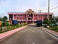
Meycauayan City Hall
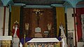
Shrine in St. Bartholomew Church
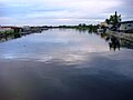
The Meycauayan River
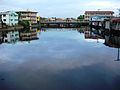
Bridge over the Meycauayan River


