
Norzagaray
| Municipality of Norzagaray | |||
| Location of Norzagaray in the province of Bulacan | |||
|---|---|---|---|

|
|||
| Basic data | |||
| Region : | Central Luzon | ||
| Province : | Bulacan | ||
| Barangays : | 13 | ||
| District: | 3. District of Bulacan | ||
| PSGC : | 031413000 | ||
| Income class : | 1st income bracket | ||
| Households : |
May 1, 2000 census
|
||
| Population : | 111,348 August 1, 2015 census
|
||
| Population density : | 359.5 inhabitants per km² | ||
| Area : | 309.77 km² | ||
| Coordinates : | 14 ° 55 ' N , 121 ° 3' E | ||
| Postal code : | 3013 | ||
| Website: | Norzagaray on the website of the Bulacan Province | ||
| Geographical location in the Philippines | |||
|
|||

Norzagaray is a Filipino municipality in the province of Bulacan , in the administrative region III, Central Luzon . According to the 2015 census, Norzagaray had 111,348 residents who lived in 13 barangays . It is classified as a first income class community in the Philippines and as partially urbanized .
Norzagaray's neighboring communities are San Jose del Monte City and Rodriguez in the south, General Nakar in the east, Santa Maria in the east, Angat in the northwest, and Doña Remedios Trinidad in the north. The topography of the city is characterized by the Sierra Madre mountains .
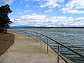
The Angat dam, which dams the 37 kilometer long Angat reservoir , is located on the territory of the municipality . This is the most important source of drinking water for the metropolitan area of Metro Manila . To protect it, the 57,891 hectare Angat Watershed Forest Reserve was established.
Barangays
|
|
gallery

The crest of the Angat dam
The crest of the Angat dam

Angat reservoir


